Category: Arizona

  • Havasu Falls

    Havasu Falls

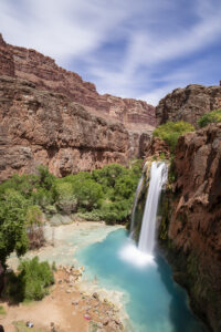
    I finally got a chance to hike to a place I’ve been meaning to get to for the past twenty years-Havasu Falls in Arizona. In recent years, the falls has become an incredibly popular destination, and as a result, requires winning a permit through an on-line lottery application. The Havasupai Indian tribe that runs the lottery has also raised the price of the stay significantly in the past decade to $455 for the three-night stay (by comparison, the same three-night trip would have cost $94 in 2014). But the hassle and cost is worth it. Havasu Falls is one of the most incredible waterfalls I’ve seen, looking completely out of place in the desert canyon it’s located in.

    The trek is epic requiring a 10 mile hike in near the Grand Canyon. The Hulapai Hilltop trail starts atop a large canyon rim. You lose 2400 feet in elevation, much of it over the first mile (yes, your calves are going to feel it). The next part of the hike meanders along a wash through a deep canyon. The canyon is very pretty in parts as the sandstone walls are adorned in desert varnish. At about mile 6, the trail flattens out as the canyon opens up. Shortly, you will cross a bridge over the creek. The environment becomes more riparian and there are many cottonwoods along this stretch. Soon, the village of Supai comes into view. This is part of the Indian reservation so there are strict rules against photography in this part of the hike. The village contains a couple of places to stop for fry bread. I recommend the sweet variety coated in powdered sugar and honey (mine also came with fresh strawberries). Once through the village the trail continues to descend toward Havasu Falls. About a mile from the campground, you will come to Navajo Falls. The creek is very wide here making for a quite pretty waterfall. After rounding a curve (fenced off due to erosion), the trail finally makes it way to the top of Havasu Falls. The noise is thunderous as the creek plummets 70 feet below. Given the presence of calcium limestone, the pool is an iridescent turquoise color. You feel like you’ve been transported to the Caribbean.

    After a dip in the falls, it’s time to find a camp site. There are a number of them scattered throughout the mile-long course of the campground. There are many several sites along the creek itself as well as a number back in the cottonwoods. Amazingly, each site has its own picnic table. The campground ends at Mooney Falls another beautiful waterfall. The descent to Mooney is not for the faint of heart, however. You have to take two sets of rocks stairs through the limestone cliff and then climb backwards down rock stairs cut into the sheer face of the cliff. It’s about 100 foot drop over the edge. Most people are able to do this part of the trail but given my fear of heights, I passed. The trail continues about 2 more miles to a set of large limestone pour overs known as Beaver Falls that apparently make great swimming holes.

    The highlight of the trek of course is Havasu Falls. There are a number of deep pools below the falls that make for great swimming. In the afternoon, this area gets quite crowded. There are a lot of people that have made the trek with you. This is probably due to the fact that hikers can reserve pack horses (for $400) to carry their gear. While this opens the trail to a greater number of people, it does make it seem a little less natural and unspoiled at times. Thankfully, the large campground seems to support the large number of people. I never felt like things were overcrowded.

    After dinner, stargazing is the thing to do here. Be aware, it is too hot in summer to put the rain fly on. The views of the stars was amazing. You are 90 miles from Seligman and 135 miles from Kingman. There is no hint of light pollution here. Given the new moon, the view of the Milky Way way incredible once the clouds cleared.

    While the weather is nice in June, I have to say the heat was intense. It was 104 in the campground and 113 in Las Vegas the day after my trip. But curling up near Havasu Falls to read a book is a great way to pass the afternoon. Due to the heat, I woke up at 4 am to hike out. The 10 mile return hike is almost all up hill and took me 6.5 hours to complete. It was 94 degrees at the Hilltop summit parking lot when I returned to the car at 11 am. Uggh. Bring lots of water for this adventure. You will need it.

    To reach the trailhead, you have to drive 135 miles from Kingman Arizona or 90 miles from Seligman. The closest motel is the Grand Canyon Caverns Inn where you must check in. It is about 5 miles east of the turn for Indian Route 18 located on Route 66. You can also stay in Selgiman about another 25 miles east. The reward here is Lilo’s Diner, a quality restaurant. Flights from either Las Vegas or Phoenix are the closest major airports located 3.5 to 4 hours away.

  • White Pocket 2023

    White Pocket 2023

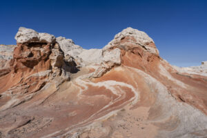
    I first went to White Pocket in 2012. It was a surreal experience as the swirls in the rock formation s defy explanation. I had a chance to go back this week and was not disappointed. While White Pocket has surged in popularity (as have many things in the desert southwest), it is still a place worthy of a visit. Although I would have loved to have spent the night and photographed in the -golden hour and at night, a day tour was all I could muster. It still is a magical place, even at midday. A young woman on our tour from Ho Chi Minh City even posed in a red dress for me. All in all, it was a beautiful day.

  • Arizona Wildlfowers 2023

    Arizona Wildlfowers 2023

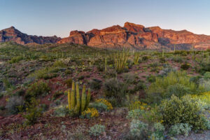
    I flew to Arizona to check out the wildflowers for a short trip this week. I saw a few great shows of wildflowers but it took some driving to find them. Some areas are experiencing a superbloom of flowers while others, especially near Tucson, are barely green. The best areas I found were the Superstition Mountains near Apache Junction just east of Phoenix, Organ Pipe National Monument near Ajo, and Highway 77 south of Globe.

    I began my trip by driving down to Organ Pipe. I had come too early to see the great show in 2019 but this year was also worth the trip. Brittlebrush is blooming like crazy in some spots of the park and a field of lupine was blooming in profusion near the park entrance. There was not the variety of wildflowers seen in other years like 2005 but it was still pretty to see. Brittlebrush is booming along the mountain loops. The Coulter’s lupine in particular were right at their peak bloom. I took a hike on the Arch trail and found a few poppies blooming as well.

    Lost Dutchman State Park between Phoenix and Superior was lush green this year. It made for quite the sight. Unfortunately, the weather was rainy the morning I was there so not much time to explore. The rain stopped by the time I got to the Peralta Trailhead on the backside of the park and it was full of brittle brush, I also found a ton of lupine atop one of the nearby hillsides. I then traveled to Globe and headed a little ways down Highway 77. Some nice fields of poppies were blooming on the hillsides.

  • Coyote Buttes

    I love traveling to southern Utah in the winter. The light has a warmth that blends masterfully with the red rock landscape of of southern Utah. One of my favorite places to visit is the Coyote Buttes in the Paria-Vermillion Cliffs Wilderness. Located on the Arizona/Utah border, this area boasts some of the most interesting geology and landscapes the U.S. has to offer.

    North Coyote Buttes and the Wave

    A trip to southern Utah wouldn’t be complete without trying to visit North Coyote Buttes and the famous Wave formation. The trick–the BLM has set up a permit system whereby only 20 per day (10 by advance on-line lottery and 10 by next-day in-person lottery) are permitted to hike in the area. The scene at the BLM office Kanab on Friday when I showed up was surreal–193 people were vying for 30 permits. Luckily, my number got drawn and I got to hike the area with my son. What a cool experience.

    The Wave is the centerpiece of this small chunk of wilderness. It is a collection of sandstone swirled in almost inconceivable directions. The area also has many other things to explore including Top Rock above the Wave and the Boneyard across the canyon from it. Due to wind and weather, I only had the opportunity to explore the Wave this time around. But I still got my $7 worth.

    The Hike

    The hike to the Wave is fairly straightforward despite having no marked trail for much of it. The hike starts at the Wire Pass trailhead off of House Rock Valley Road. The trail follows the wash for the first half mile and then proceeds up a sandy embankment (marked by a sign to the right stating you are entering the permit area). As you descend back down and cross another small wash, the fun begins. You have to aim for a low saddle (about 11 o’clock to your left) in a series of sandstone formations that cuts across the path in front of you. The saddle is a fairly short climb and takes only about 5 minutes to ascend. From the saddle, you can then pick out the route fairly easily. You can see a signpost at a 45 degree angle to your right. Eventually, you are aiming for the right side of the Twin Buttes that can be seen off to your right. Once you reach the Twin Buttes, the crack in the wall (a dark vertical shadow on the mostly white Top Rock) becomes visible. The Wave is located below this crack. You simply keep your route straight at this crack. The last difficult obstacle occurs just before the entrance to the Wave. You must cross a sandy wash and then ascend a steep sand dune just below the entrance to the Wave. The entrance is through the little slot canyon of wavy sandstone. The hike is just over 3 miles long and takes under 1.5 hours each way. Be sure to aim for the left side of the right most set of buttes (amongst many) on the return. These are the Twin Buttes. A fence line can be seen descending the right side of the butte.

    South Coyote Buttes Paw Hole

    The South Coyote Buttes is a landscape worthy of exploring Coyote Buttes is subject to a permit and lottery system established by the BLM to prevent overuse in the area. In the winter, it issues permits for both North and South areas for the following three days (Saturday, Sunday, and Monday) on Fridays. I secured a permit for South Coyote Buttes for later that day after the North/Wave lottery had ended. This wouldn’t leave me enough time to explore both Paw Hole and Cottonwood Cove so I opted to explore just the Paw Hole region. Paw Hole doesn’t have the color variety of Cottonwood Cove, but it does have some bizarre rock formations that make for great photo compositions.

    I parked my car along the entrance road and started hiking around 1 pm. I explored the buttes to the right of the entrance to begin with. There is no discernible path through the tall buttes but I found a low point slightly to the right of the fence line and climbed past the initial set of buttes. Back behind this area is a cool little canyon with a mini wave to it. I continued uphill to the north. The landscape was mostly uninteresting for the next 1/2 mile or so, however. I then came upon an area that featured some buttes with crazy fins on the side and a large alcove. This was fun to explore and I marked a point to return to near sunset. Next, I hiked another 1/2 mile or so to a region that had some cool box work. Finally, I stopped at the summit of the Paw Hole region. This area has a feature I like to call batwing arch. It has box work or lacy rock with a hole in the middle giving it the appearance of a batwing.

    The Hike

    The Paw Hole entrance is located 14 miles down House Rock Valley Road and then up a jeep road to the left another 2.5 miles. There are several areas to park off the road if you get concerned by the sandy conditions. Once at the trailhead, you have two choices. You can either skirt the buttes to the left and then finally ascend once you reach the buttes with the pronounced fins on them or you can stay to the right and pick a trail through them. Don’t go perfectly straight from the trailhead. There is no obvious route through the buttes form here. If you choose the right most path, there is a small wave and canyon behind the big butte just to your left once you’ve crossed over the first set of buttes. Then, you keep steeply climbing the next couple set of buttes. I particularly like the box work that forms a couple of Xs on the sides of the next series of buttes. At around the 1 mile mark, you can see an alcove off to the left and the previously mentioned buttes with pronounced fins. Stay to the right and climb through the brush (there is a steep drop to your left). At mile 2, you will reach a series of buttes with amazing box work. The last of these contains batwing arch. From this point, you can continue on to Cottonwood Cove. Go straight for about 1/2 mile and then veer right to miss the canyon in front of you. At around 3.5 miles, you will arrive at the first of the multicolored features in Cottonwood Cove. Explore at your leisure. Retrace your steps to the trailhead at Pawhole or arrange a guide to pick you up at the Cottonwood entrance.

  • Waterholes Canyon

    On a recent trip to southern Utah and northern Arizona, I stopped by Page, AZ.  I avoided Antelope Canyon like the plague.  The crowds there now are out of control.  Plus, the Navajo Nation has banned tripods at Lower Antelope Canyon.  As I drove by, I counted at least 100 cars in each parking lot on a Monday morning in April.  Yikes!  But all was not lost.  I obtained a permit to hike the lower portion of Waterholes Canyon.  This has far less people and has some exquisite rock formations to see.  

    The Hike to Waterholes

    Hiking Waterholes Canyon is relatively easy.  The canyon is accessed from a short hike in from the rim.  The trail descends steeply into the canyon about 100 feet.  The trail is well marked with stones and red paint at the entry point to the canyon. It is then about a mile and a quarter to the ladder up stream or about a quarter mile to the ladders down stream.  Both sections have some nice slot canyons and the rock turns an orange color near midday.  The canyon walls are beautifully curved and make some interesting photographic compositions. You can hike to the power poles but past that point you have to hire a guide.  The upper section has ever more beautiful narrows.   I didn’t go past either ladder but the bottom one has an old car wreck you have to negotiate around.  

    Horseshoe Bend

    I also hiked down to Horseshoe Bend to watch the sunset since it is only a couple of miles north of Waterholes.  I was amazed at the crowd.  There must have been 200 people there.  The parking lot is now three times the size of what it used to be.   The hike is about a half mile down a steep sand dune until you reach the canyon rim. What a great place to watch the sunset, though.  

    Driving Directions

    Waterholes Canyon is located about 5 miles south of Page on Highway 89 at mile marker 542.  Park on the left side of the road and begin hiking into the canyon. Horseshoe Bend is located 2 miles north and parking is on the right hand side as you are heading south on 89.   A permit for Waterholes can be obtained at the Navajo office in Lechee.

Plugin from the creators ofBrindes Personalizados :: More at PlulzWordpress Plugins