Category: Wyoming

  • Wyoming Reflections

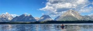
    I went to Jackson, WY to pick up some photographs that had been on display for the past year at St. John’s Hospital. While I was up in the area, I stopped at String Lake in Grand Teton National Park to catch the sunrise and then kayaked around Jackson Lake for a while. The next morning I stopped at Lake Marie and Mirror Lake in the Snowy Range on the way back to Colorado. What beautiful mornings. It was perfectly calm. The smoke from recent wildfires made the color really pop on the mountains!

  • Grand Teton and Yellowstone

    Grand Teton and Yellowstone

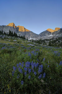
    After backpacking to Alaska Basin, my wife and I spent a couple of days in Grand Teton National Park and Yellowstone National Park. With not a lot of time to spend, we hit some of the highlights of each park. We kayaked in Jackson Lake, took in the sunrise at Oxbow Bend, and then headed to Yellowstone. We caught the eruption of Old Faithful and toured around the Grand Prismatic Pool area. I really liked Firehole Falls at the beginning of the Firehole River canyon. The best was yet to come, however. I found a huge field of wildflowers near the shore of Yellowstone Lake and then we caught the sunset at Gull Point along the lake. What color! In the morning, we made our way out of the park to pick up our son at Buffalo Bill Boy Scout camp. There were more fields of flowers just before Sylvan Lake. The yellow was quite a contrast with the stark tree poles killed by forest fires in the area. Unfortunately, there was not much wildlife to be spotted. Only the occasional bison and elk. I think the heat had many animals hiding up high.

  • Alaska Basin

    Alaska Basin

    My wife and I just did a backpacking trip to Alaska Basin on the west side of the Tetons. The trip is not in Grand Teton National Park, but that makes it better in my opinion. There are no permits needed for the region and the scenery is just as iconic. The trail features several cascades, great wildflowers, and terrific mountain views. Alaska Basin contains several small ponds and lakes that make for some great photography.

    The trail starts at the South Teton Canyon Trailhead east of Driggs, Idaho. The first 2 miles meanders by the creek and is fairly flat. Then the fun starts. The trail climbs steadily through four or five meadows that filled with wildflowers. The views of the surrounding mountains are good as well here. At mile 2.7, the trail intersects with the trail to the Devil’s Stairs on the right. This side trail makes a loop with the main trail up at the basin if you so desire. We met several people doing the entire 16 miles in a day. The main trail continues steeply upward from this point. It climbs above the creek and enters a pine forest. Around mile 4.5, the trail ascends steep switchbacks and arroiuves at a meadow filled with columbine and cow parsnip. The trail levels off at this point and crosses the creek at mile 5.4. This crossing is a little tricky, especially on the way back. Watch for loose logs and rocks. There are two very nice cascades in this area as well.

    Starting at the 6 mile mark, the trail again ascends some rock stairs and arrives at a small meadow. Some nice views can be had here and there are nice fields of wildflowers in abundance. You can also see a large waterfall in the distance here. The trail then renters the forest and climbs up to the junctions with the Hurricane Pass trail at mile 7.7. This is where Alaska Basin lies. We day hiked this side trail but did not quite make it to the pass. This trail steeply climbs a rock bench to Sunset Lake with stunning views from above the lake. The route up to the pass is filled with wildflowers past the lake. Hurricane Pass provides panoramic views but I wimped out.

    Back in Alaska Basin, we camped near one of the small lakes. Mirror Lake is the biggest of the six or so lakes in the area and is the most photogenic in my opinion. It also gets the most campers. The trail divides .1 mile past the junction with the Hurricane Pass Trail. Rather confusingly, the trail for Mirror Lake is signed as the left branch, but Mirror Lake is actually more easily accessed by the right branch trail to Mt Meek Pass. No matter. Each of the lakes has a little different view and is worth exploring.

    One of the amazing features of this valley is that the sun has very little blocking it as it sets to the west. Thus, the mountains behind the lakes light up and turn amber and red in the evening light. It is quite a sight to behold. The back side of South Teton dominates the scene.

    Getting There

    Take Highway 22 west of Jackson, WY to Victor, Idaho. The road becomes Highway 33 in Idaho. Follow the road north to Driggs. Turn right on Ski Hill road and follow it about 5 miles. Turn right onto Teton Canyon Road. Follow the dirt road for about 4.6 miles until it dead ends at the South Teton Canon trailhead.

  • Clear Lake-Wind Rivers

    Clear Lake-Wind Rivers

    Clear Lake in the Big Sandy Lake area of the Wind River range is one of the prettiest alpine lakes I’ve visited. It is set in a large bowl with large prominent mountain peaks surrounding it. Its large size adds to the drama of the setting. Wildflowers dot the meadows surrounding the north side of the lake as well.

    To reach the lake, hike the Big Sandy trail to Big Sandy Lake at the southern end of the wilderness. Then skirt the left side of the lake, pass the junction with the Big Sandy trail to Jackass Pass, and continue around the lake until you reach a crossing of the Big Sandy river. Several logs have been placed across the stream to aid in the crossing. Just before the crossing, you will see the only sign for Clear Lake–it points to Black Joe Lake and Clear Lake to the right. However, once the trail splits after the crossing, no signs tells you which way to go. I made the mistake of going left toward Black Joe lake. You can still reach Clear Lake from here but you needlessly ascend 300 more feet than necessary. So save yourself the trouble and go right at the junction. The trail finishes its circle of Big Sandy Lake and then ascends some gentle switchbacks up to Clear Lake. The lake is about 1 mile past Big Sandy Lake.

    The lake itself is ringed by trees but feels very open. The trail leads around the north side of the lake and continues up to Deep Lake about 1.5 miles up the trail. Clear Lake is a great spot to watch sunrise and sunset, particularly if the winds are calm. The lake can produce some stunning reflections.

  • Cirque of the Towers

    Cirque of the Towers

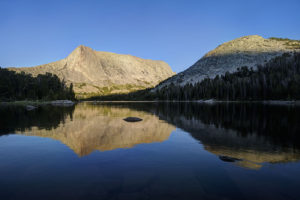
    My family and I recently backpacked to the Cirque of the Towers in the Wind River range of Wyoming. It is an amazing place where a lake is encircled by high peaks in a glacial basin. The Cirque had been on my radar as a place to visit for many years now so I’m glad I finally had a chance to get there. It was a rough hike but the effort was worth it. As an added bonus, I got to see the comet Neowise peaking out just above the horizon line one evening.

    The hike to the Cirque begins at the Big Sandy trailhead near the southern end of the range. The first section of the hike is a relatively easy jaunt to Big Sandy Lake, five miles from the trailhead. The trail begins by going through the forest before reaching a meadow around the .5 mile mark. From there, the trail begins to ascend up some switchbacks and then levels out around the two mile mark at another large meadow. Here, you begin to see views of the surrounding mountains. The trail again climbs gradually through the trees until arriving at the shores of Big Sandy Lake around mile 5. This is a good place to camp for the night or you can continue up the trail 1.5 to the incomparable Clear Lake.

    The trail skirts the left side of the lake, crosses a small stream, and reaches the junction with the Big Sandy trail to Jackass Pass at mile 5.5. The fun now begins. You gain 1700 feet in elevation in 3 miles but also lose 600 feet of elevation. For the junction, the trail immediately ascends via steep switchbacks to a beautiful meadow. It levels off for the half mile, reaching a small stream and pool. The trail crosses the creek and ascends via steep switchbacks. You climb 300 feet but then descend all 300 feet to the inlet of North Lake. Take a rest here because the trail now ascends up a steep slope through the rocks above Arrowhead Lake. It soon comes to a trail junction with the Arrowhead Lake climbing route. Go right and head up through the boulders above Arrowhead Lake. Here you begin to glimpse the amazing scenery of the area. Peaks soar around you. When you reach the high point, your heart sinks as you can now see the trail drops most of the way down to Arrowhead Lake before reascending to Jackass Pass. The trail splits in three after the descent, as the left branch descends the rest of the way to Arrowhead Lake, the central branch leads to the base of Cirque, and the right branch ascends the pass. Take the right fork and do one more steep climb before you finally reach the summit of the pass.

    At the pass, take in the view. The peaks of the Cirque of the Towers surround you and Lonesome Lake can be seen far below you. Peaks such as the Wolf’s Head, Shark Nose, and Pingora Peak cut a distinct profile. Follow the trail down toward the lake. You can proceed left to a large waterfall and the head of the basin or you can go right and camp past the lake and continue on the trail toward Papoose Lake. I camped in the area above the basin so I could visit the lake and waterfall. The lake contains many small cutthroat trout which are willing biters.

  • Gap Lakes

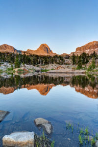
    I backpacked to the Gap Lakes in the Snowy Range of Wyoming just before the eclipse.  This is a pretty area with several small lakes and tarns just a short distance form the trailhead.  I camped near South Gap Lake and explored some tarns around the area.  There are many small ponds with beautiful reflections to photograph in this area.  Lewis Lake at the trailhead is perhaps the prettiest of all the lakes.  I will have to return to this area to do some fishing.  

    Getting There

    The trailhead to the Gap Lakes is located at the Libby Lake and Lewis Lake picnic ground which is about a half a mile from the summit of the Snowy Range road. Proceed west out of Laramie, Wyoming for about 30 miles on the Snowy Range Road to reach this area.  The trail itself climbs about two hundred feet in elevation from Lewis Lake and arrives at the Gap Lakes in less than a mile.  You can explore the trial further to reach Deep Lake and other lakes in the region or take a different trail to reach Mirror Lake to the West.  

Plugin from the creators ofBrindes Personalizados :: More at PlulzWordpress Plugins