Category: Landscape

  • Arches and Capitol Reef

    Arches and Capitol Reef

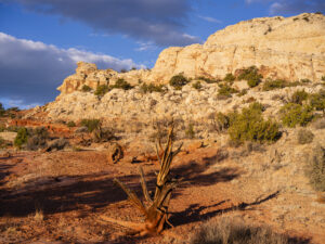
    I took a quick trip to Arches and Capitol Reef National Parks in Utah. I love the skies in October and the beautiful fall color this time of year. Late October is the perfect time to visit Capitol Reef as the cottonwoods put on a show.

    I stopped at Arches to hike up to Delicate Arch and capture the sunset before I head further west. The light was great as I had a cloudless sky. In the morning, I hiked up to Longbow Arch. This arch is accessed form the parking lot for Poison Spider Mesa. It is a challenging two-mile hike that brings you to an impressive arch that has just a crack of daylight behind it. The trail climbs steeply from the parking lot and ascends a section of steep slick rock that climbs out of a small bowl. There are iron handle grips to assist your climb in this one section. After about 1/2 mile, the trail runs sharply to the right and heads up into rocks mounds of Poison Spider Mesa. It is quite scenic through this section of trail. The trail then veers to the right in about 1 mile as it makes its approach to the arch. The trail climbs up to the base of the arch where you can watch a number of repellers come through the arch on ropes. This is an easy trail to follow with green paint splotches leading the way.

    In the afternoon, I made my way to Capitol Reef. I stopped at Crack Canyon for a quick hike. The Canyon is located on the back side of Goblin Valley State Park and the trailhead is accessed via a rough dirt rough. The Canyon features some amazing swiss cheese rock in its namesake narrows section. The walls converge here with just a crack of sunlight appearing above. The walls are a beautiful orange/brown color in this section. I had my camera stolen out of my car the last time I came here in 2020, so it was good to reclaim some memories without incident.

    As I drove toward Capitol Reef, I marveled at the trees along the Fremont River which were a brilliant yellow. I wandered down one road and got some nice photos of the trees contrasted with the chalky buttes behind them. I finally arrived at Capitol Reef, and took some nice sunset photos. The color in the rocks really glowed about 10 minutes before sunset. The next day, I hiked the Rim Overlook trail and was treated to a beautiful sunrise over Pectol’s Pyramid. I saw the sun light up the Hickman Bridge just underneath me. I turned around at the 2.3 mile mark but could have gone on to the Navajo Knobs another 2.2 miles further down the trail. Even so, the view from the turnaround was great. Unfortunately, clouds were pouring in quickly so I headed down just in time.

  • Fall Color Steamboat, CO

    I took a drive near Steamboat Springs, CO to see the fall color this week. It was really vibrant this year with numerous reds and oranges interspersed amongst the normal yellow aspen. The weather was perfect, too. It was a great chance to try out my new Hasselblad X2dii. What an amazing camera!

  • Lake Charles, Holy Cross Wilderness

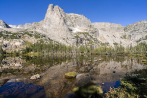
    My son and I backpacked to Lake Charles in the Holy Cross Wilderness recently. The lake lies at the head of a glacial valley in the Holy Cross Wilderness near Eagle, CO. After spending the night at the lake, we hiked the mile up to Mystic Island Lake, another pretty lake in the chain.

    The trail starts at the end of a Forest Service Road. It ascends steeply for about a quarter mile and then levels off for the next mile as it passes through aspen forest. It crosses a small boulder field around the 1 mile mark. Around 1.75 miles, you enter the Holy Cross Wilderness. You pass through a couple of small, marshy meadows. You will then pass small streams on the left and after the third stream, around the 2.75 mark, the trail begins to steadily gain elevation. Over the next 2 miles, the trail seems to relentlessly ascend the rocky terrain. The main stream will come back into view and the trail passes by some small cascades. Finally, you will reach the lake around the 5 mile mark. It is a sight to behold. The mountains soar above the lake. It is one of the prettiest valleys in Colorado.

    The continues around the left side of the lake and then ascends about 200 feet to Mystic Island Lake. There is only a small steep section to reach the lake.

    If you are patient, try your hand at catching the small cutthroat trout that live in both the lakes.

    The weather was a mixed bag on the trip. It was humid on the hike in and then it poured after dinner as we were trying to set up camp. Nothing like water, mud, and pine needles coating a tent. The clouds parted just before sunset lighting up the mountains in the distance. A very special moment. The clouds cleared and I was treated to a star show and a great view of the Milky Way.

  • Zion area

    Zion area

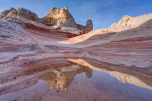
    I traveled to southern Utah near Zion National Park. My two big stops were the Subway hike in Zion and White Pocket in the Paria/Vermillion Cliffs Wilderness.

    The Subway

    I had made one prior attempt to hike the Subway in Zion but never made it past the waterfall you have to hike over. This time I came prepared with water shoes. The hike starts off the Kolob Reservoir Road about 13 miles from the visitor center. I picked up my permit and headed to the trailhead. The first part of the hike meanders through junipers and then descends steeply (400 ft.) to the canyon floor around the 1.5 mile mark. The trail then skirts the creek for the next couple of miles, crossing it several times. There are a few areas where the trial climbs over boulders and trees. In April, the water wasn’t too high so this was not much of an issue. At mile 3, I reached a large, stepped waterfall with huge boulders in the creek. The only way to keep going is to walk through the water up the waterfall. The stair steps are relatively easy to climb so this was not much of an issue. But watershoes are helpful here since the water can be six inches deep in places. In about a half mile, I came to another stepped cascade. This one is a beautiful spot for some photography. This falls can be negotiated by walking around to the right of it. Just above this fall, is the famous crack where water flows through like a train track. It makes for some cool photos but the rock is incredibly slippery here so beware. The Subway is just a couple hundred yards around the bend from this area. The Subway itself has some amazing sculpted pools and the curved rock that forms the Subway. I was lucky enough to have a couple of large tree branches sticking out of the pools to create some cool looks. The trail continues up some small riffles (very slick) to where it reaches hip deep pools. Just beyond is a little waterfall that I did not see. Little too cold in April to trudge through the pools. The famous tree log is one level higher, but I would have needed a 15 ft rope to ascend the falls to get there.

    White Pocket

    The next stop I made was at White Pocket. It is located just south of Big Water, UT but to reach the area requires about 1.5 hours of backroad travel on 4-wheel roads. I went with an outfitter to avoid getting stuck in the sand along the way. I camped out to try and take advantage of the golden hour and overnight but clouds ruined my plan. Sunset and overnight were a bust. I did get some nice light in the morning so here are a few photographs of the very bizarre White Pocket area. The area gets its name from the holes or “pockets” in the rock that trap rain water. There was a little water in some of them so I was able to capture a couple of reflections. I also hiked to some of the more remote formations that torus don’t stop at. One was reminiscent of South Coyote Buttes with lots of sandstone fins. Very cool.

  • Odessa Lake Trail

    Odessa Lake Trail

    This week I hiked to Odessa Lake in Rocky Mountain National Park, a place I’d never been before. The hike starts at the Bear Lake trailhead, passing Lake Helene, and ending up at Odessa Lake. It is a beautiful but challenging 8 mile RT hike.

    The first part of the trail follows Bear Lake and then quickly veers uphill after .2 of a mile. The trail climbs above Bear Lake and then veers sharply to the left. The lake is 3.6 miles from this point. For the next .5 mile, the trail heads steeply uphill through the pine forest. At this point, another trail junction makes a sharp left (toward the summit of Flattop Mountain). Ignore this junction and continue heading straight. The trail continues to climb. Soon, you will pass a clearing where views of the Mummy Range open up to the north. You will come to a large boulder field and avalanche chute that provides more open views.

    The trees begin to thin at this point and views of the mountains to the west appear. The trail through this section is quite easy. The grade is only a gentle uphill slope. As views of the mountains open up, the trail makes a hard right turn. At this point (around mile 3.5), a small social trail to the left is visible. Take this trail and after .2 mile, Lake Helene awaits. It is willow choked around the shore but a few spots are accessible. Follow the indistinct social trail to the left and visit some of the open spots along the lake. Lake Helene is quite shallow so the reflections are amazing here.

    After rejoining the main trail, continue heading north on the trail if you want to visit Lake Odessa. Here’s the bad news–the trail descends quite steeply about 600-800 feet to reach the lake. This means you will have to climb this steep and rocky slope on the return unless you through-hike to the Fern Lake trailhead and catch the shuttle back to Bear lake (this adds about 1-1.5 miles to the total hike). Odessa Lake is visible in a couple of spots as you descend. The trail passes the lake before backtracking to the shoreline.

    Enjoy lunch at the lake! You will need to recharge your batteries before the steep uphill climb back to Lake Helene. This part of the trail took me about 45 minutes. Once you reach this spot, however, it all downhill from here. The entire hike takes about 5-5.5 hours.

  • Wyoming Reflections

    I went to Jackson, WY to pick up some photographs that had been on display for the past year at St. John’s Hospital. While I was up in the area, I stopped at String Lake in Grand Teton National Park to catch the sunrise and then kayaked around Jackson Lake for a while. The next morning I stopped at Lake Marie and Mirror Lake in the Snowy Range on the way back to Colorado. What beautiful mornings. It was perfectly calm. The smoke from recent wildfires made the color really pop on the mountains!

  • Pitkin Lake

    It had been about 25 years since I had been up to Pitkin Lake in the Eagles Nest Wilderness near Vail so I decided to go back this past week. Pitkin Lake is a beautiful place. The hike features a couple of waterfalls, wildflower-filled meadows, and soaring peaks. What’s not to like? The steepness of the hike, for one. This is a challenging backpack. Although the trail is listed at 4.8 miles, the trek is far longer. It gains 3,000 vertical feet and takes about 4.5 hours and about 3.75 hours going down. My guess is this hike is closer to 5.7 miles each way, almost 2 miles longer roundtrip than advertised.

    The trail starts in East Vail by crossing Pitkin Creek almost immediately. Then the fun begins, It climbs steeply over the next .5 mile, gaining about 500 feet in elevation in the process. The trail mellows out a little but and then gets pretty flat as it wanders through aspen trees. At mile 1.9 (or 2.7 in actual distance), the trail provides an overlook of a large waterfall off to the right. From here, the trail ascends at a steep incline for the next 1.5 miles before it reaches a second waterfall, this time on the left. This stretch of trail left my quads burning and required a couple of breaks. It flattens out thankfully just before coming to a second waterfall at around mile 3.5 (4.3). Access is limited due to rocks and willows. I could not get a decent photo of it. Past the waterfall, the trail ascends steeply to the right of the waterfall and then alternates steep sections with flatter ones. The trail is quite marshy through this section and is quite mosquito-filled. Finally, the trial opens up into a beautiful meadow. The flowers were just beginning to pop in this section.

    Once you get to the lake, all is forgiven, however. It is a serene setting. Colorado cutthroat trout inhabit the lake and my son and I caught a couple. /we saw no none else camped in the basin which was amazing.

    Getting to the trialhead

    Parking is limited at this trail. There are about 20 spots but they are limited to three hours (not enouh time to do even half the trail). The best course is to park near the vail transit center and catch the free East Vail hiker express. The shuttle makes a few stops at the most popular trailheads. The one for this hike is Falls at Vail. The shuttle stop is about a .25 mile downhill from the trailhead. If you are backpacking and need overnight parking, the Redstone parking garage in West Vail is your best bet. It costs $15 for the night (as opposed to $30 in the lot by the transit center). You will need to walk an additional mile to get to this garage or catch the free shuttle from the transit center.

  • Havasu Falls

    Havasu Falls

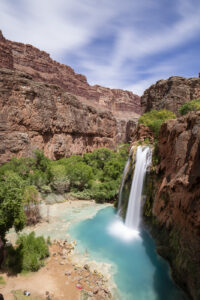
    I finally got a chance to hike to a place I’ve been meaning to get to for the past twenty years-Havasu Falls in Arizona. In recent years, the falls has become an incredibly popular destination, and as a result, requires winning a permit through an on-line lottery application. The Havasupai Indian tribe that runs the lottery has also raised the price of the stay significantly in the past decade to $455 for the three-night stay (by comparison, the same three-night trip would have cost $94 in 2014). But the hassle and cost is worth it. Havasu Falls is one of the most incredible waterfalls I’ve seen, looking completely out of place in the desert canyon it’s located in.

    The trek is epic requiring a 10 mile hike in near the Grand Canyon. The Hulapai Hilltop trail starts atop a large canyon rim. You lose 2400 feet in elevation, much of it over the first mile (yes, your calves are going to feel it). The next part of the hike meanders along a wash through a deep canyon. The canyon is very pretty in parts as the sandstone walls are adorned in desert varnish. At about mile 6, the trail flattens out as the canyon opens up. Shortly, you will cross a bridge over the creek. The environment becomes more riparian and there are many cottonwoods along this stretch. Soon, the village of Supai comes into view. This is part of the Indian reservation so there are strict rules against photography in this part of the hike. The village contains a couple of places to stop for fry bread. I recommend the sweet variety coated in powdered sugar and honey (mine also came with fresh strawberries). Once through the village the trail continues to descend toward Havasu Falls. About a mile from the campground, you will come to Navajo Falls. The creek is very wide here making for a quite pretty waterfall. After rounding a curve (fenced off due to erosion), the trail finally makes it way to the top of Havasu Falls. The noise is thunderous as the creek plummets 70 feet below. Given the presence of calcium limestone, the pool is an iridescent turquoise color. You feel like you’ve been transported to the Caribbean.

    After a dip in the falls, it’s time to find a camp site. There are a number of them scattered throughout the mile-long course of the campground. There are many several sites along the creek itself as well as a number back in the cottonwoods. Amazingly, each site has its own picnic table. The campground ends at Mooney Falls another beautiful waterfall. The descent to Mooney is not for the faint of heart, however. You have to take two sets of rocks stairs through the limestone cliff and then climb backwards down rock stairs cut into the sheer face of the cliff. It’s about 100 foot drop over the edge. Most people are able to do this part of the trail but given my fear of heights, I passed. The trail continues about 2 more miles to a set of large limestone pour overs known as Beaver Falls that apparently make great swimming holes.

    The highlight of the trek of course is Havasu Falls. There are a number of deep pools below the falls that make for great swimming. In the afternoon, this area gets quite crowded. There are a lot of people that have made the trek with you. This is probably due to the fact that hikers can reserve pack horses (for $400) to carry their gear. While this opens the trail to a greater number of people, it does make it seem a little less natural and unspoiled at times. Thankfully, the large campground seems to support the large number of people. I never felt like things were overcrowded.

    After dinner, stargazing is the thing to do here. Be aware, it is too hot in summer to put the rain fly on. The views of the stars was amazing. You are 90 miles from Seligman and 135 miles from Kingman. There is no hint of light pollution here. Given the new moon, the view of the Milky Way way incredible once the clouds cleared.

    While the weather is nice in June, I have to say the heat was intense. It was 104 in the campground and 113 in Las Vegas the day after my trip. But curling up near Havasu Falls to read a book is a great way to pass the afternoon. Due to the heat, I woke up at 4 am to hike out. The 10 mile return hike is almost all up hill and took me 6.5 hours to complete. It was 94 degrees at the Hilltop summit parking lot when I returned to the car at 11 am. Uggh. Bring lots of water for this adventure. You will need it.

    To reach the trailhead, you have to drive 135 miles from Kingman Arizona or 90 miles from Seligman. The closest motel is the Grand Canyon Caverns Inn where you must check in. It is about 5 miles east of the turn for Indian Route 18 located on Route 66. You can also stay in Selgiman about another 25 miles east. The reward here is Lilo’s Diner, a quality restaurant. Flights from either Las Vegas or Phoenix are the closest major airports located 3.5 to 4 hours away.

  • Northern California 2024

    Northern California 2024

    Northern California has gotten another round of epic rainfall this winter. As a result, the area is brimming with greenery this spring. I visited Point Reyes, Mt. Diablo, Napa Valley, and some waterfalls near Auburn, CA. All in all, it was fun and rewarding spring break trip.

  • Miami

    Miami

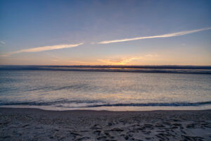
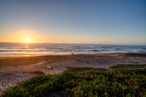
    My family and I traveled to Miami over Christmas this year. We took in a sunrise at South Beach, strolled through the Art Deco district, and toured Viscaya. I also grabbed a quick walk around Bill Baggs State Park on Key Biscayne as well as Homestead Bayfront Park. Unfortunately, our snorkel adventure in Biscayne National Park got canceled due to rain. Winter weather is unpredictable everywhere I guess.

Plugin from the creators ofBrindes Personalizados :: More at PlulzWordpress Plugins