Category: Colorado

  • San Juan Mountains of Colorado

    San Juan Mountains of Colorado

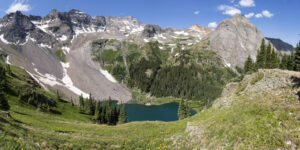
    I spent a few days in the San Juan Mountains of Colorado recently. I love the area because lakes abound as do wildflowers. I started my trip in American Basin near the summit of Cinnamon Pass and ended up hiking the Blue Lakes basin near Ridgway. The wildflowers were abundant this year which made the trip even more rewarding.

    American Basin

    American Basin is best known for being located at the trailhead for Handies Peak, one of Colorado’s 54 fourteeners. It also boasts some glorious fields of wildflowers in late July. I had lasted visited the area in 2009 and was greeted by an explosion of columbine. While the snowfall was tremendous this past winter, the rain has not come to southern Colorado this year so the columbine were mainly absent. However, fields of larkspur and orange sneezeweed were everywhere. Also, flowers lined the stream draining the basin. The route into the basin is relatively easy until about a half mile from the Handies Peak trailhead. A high clearance vehicle of any sort will get you to this point. It is located 18 miles west of San Cristobal Reservoir near Lake City or 2 miles east of the Cinnamon Pass summit. However, above the dispersed camping area in the basin, the road becomes much rockier and all-terrain tires become helpful. If continuing over Cinnamon Pass to Silverton, I would say the same applies. The road is generally passable with high clearance but there two spots, one just below the summit and one at the junction of the Cinnamon Pass and Engineer Pass roads that more aggressive tires would be most helpful. I survived in my X5 equipped with highway tires, but not easily.

    Alta Lake

    I next ventured to Alta Lake near Telluride. The lake is located at the end of a rough road off of Highway 145 about 5 miles south of Telluride. I reached the lake and its abundant dispersed camping area after a few miles driving along the rough road. The lake boasts fishing for small rainbow trout and is a popular camping location. It is also a photogenic spot for sunset photography as a large mountain sits just behind the lake to the east. I also explored upper Alta Lake which is a quarter mile or so up a trail. It is not as photogenic and is too shallow to support a good fish population.

    Hope Lake

    The next morning I hiked to Hope Lake which is located off another dirt road past Trout Lake. Hope Lake is one of the prettiest lakes in Colorado. Its turquoise blue water stands in stark contrast to the mountains directly behind it. The lake is reachable via a 2.5 mile hike from a trailhead located at a sharp bend in the road. The trailhead is about 2.5 miles from the turn off Trout Lake road onto FR 627. The hike itself is easy for the first mile and a half and then gains most of its 1,130 foot elevation gain in the last mile. The trail begins by ascending a moderate slope for a quarter mile. It then crosses a stream and drops all of that elevation as the trail routes around a huge rock fall. The trail crosses this sharp slate field and then descends to a larger stream crossing around the 1.5 mile mark. The trail then beings its steep ascent up 22 switchbacks. Views of Vermillion Peak open up here. Across the valley, you can see Trout Lake below and Wilson and Sunshine Peak in the distance. The distinctive lizard head can also be seen. As you ascend the last of the switchbacks, fields of wildflowers are all around you. Paintbrush is the dominant flower found here. Finally, you reach the lake after a short quarter mile ascent. Hikers can continue another .7 mile to the pass above Hope Lake.

    Blue Lakes

    Not far from the town of Ridgway is the trail to the Blue Lakes in the Mt Sneffels wilderness. The trail is located at the end of County Road 7, a few miles west on Highway 62 from Ridgway. The 9 mile dirt road is normally passable by passenger car, but this year the road is in terrible condition. It is suitable for high clearance vehicles only, especially the last 1.5 miles. Huge ruts pock mark the last 5 miles of the road. I went 10 mph along this section. Once reaching the trailhead, be prepared for a steep hike. The trail is 3.3 miles to lower Blue Lake, but it feels far longer. The trail begins climbing steeply after about a .25 mile. The trail has many wooden steps through this section. After a mile, it begins to flatten out. The trail undulates here for about a half mile before crossing a large stream. The trail opens up here and features a large field of flowers, mostly cow parsnip. It then ascends steeply once more via a series of switchbacks. You reenter the forest and then come to a waterfall about mile 2.75. A small trail descends to the creek here. You pass another small waterfall before passing through a small grove of trees before coming to the lower lake. The dispersed camping is located here for the numerous backpackers that use the trail as a base to climb Mount Sneffels. Bring your fishing pole as there are large brook trout in this lake (I stupidly left mine in the car). Hikers can continue to the left of the lake and ascend the steep ridge to the middle and upper lakes. Three stream crossings are required. This year, the first requires debooting and crossing the outlet stream. Bring sandals as this area is full of sharp rocks. I found crossing right at the outlet the easiest spot. The trail veers leftward and then crosses another creek in about .2 mile. Some logs are set up here to cross but are useless. Just cross on the slightly submerged rocks. After crossing the creek, veer right. The trail was underwater here so was hard to spot. The trail ascends steeply before recrossing this small creek. With so much snowmelt, this crossing was challenging in boots but doable. The trail now makes a very steep push up the hill. A field of purple larkspur flowers grows in abundance on this hillside. Views of the lower lake and Mt Sneffels begin to open up here. The middle lake quickly comes into view on the left. The trail continues past the lake to the right to the upper lake and then the pass. Caution. I’ve hiked up toward the pass before, and the trail becomes faint through the rock scree and is impossibly steep here. A helmet and trekking poles are a must. For the truly adventurous hiker, you can take the pass over to Yankee Boy Basin near Ouray. If wishing to see Yankee Boy, my recommendation is to drive up from the Ouray side and hike through the fields of wildflowers en route to the pass from that side. See below.

    Yankee Boy Basin

    One place to see huge fields of wildflowers without doing much hiking is Yankee Boy basin. The basin is located about six miles from Ouray along the Camp Bird road. The raid is easy for the first three miles to the mine, but then steepens and requires 4 wheel drive. A large dip prevents travel for lesser vehicles as you come to a couple of large waterfalls. I parked here and hiked a couple of miles up the road. The views and flowers are impressive. Again, columbine were mainly missing this year but the huge fields of larkspur made up for it. The trailhead for the Sneffels Pass is about 2 miles from the waterfalls. My advice is rent an ATV or Jeep in town if you don’t have one and drive to the trailhead.

  • Crested Butte Wildflowers 2023

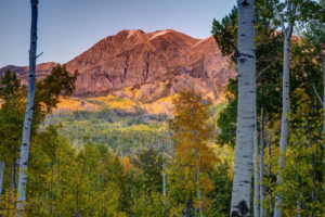
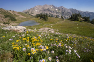
    I took a quick trip to Crested Butte to check out the wildflowers this year. The flowers weren’t as ever-present as they have been in the past but in areas that had them they were in abundance. Some of the fields of lupine and Mules Ears were resplendent. I was even treated to a sunset lighting up Marcelina Mountain at the end of the evening. The areas with the most flowers seemed to be one hillside at the start of the Brush Creek Road and then the very start of the Gothic Road leading into the East River Valley just north of town. I did not see as many flowers around the Slate River Road as I had see in the past. But all in all, this appears to be a good year for flowers in Colorado. I can’t wait to check out the high alpine flowers over the next couple of weeks.

  • Dream Lake Loop

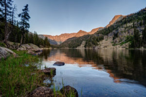
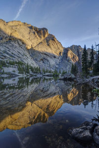
    I hiked a loop from Bear Lake parking lot in Rocky Mountain National Park yesterday. I photographed the sunrise at Dream Lake and then ventured over the hill to Lake Hiyaha about 1 mile away. Although virtually at the same elevation, the two lakes are separated by a large hill that must be scaled. So the trail ascends and descends steeply form Dream Lake. Lake Hiyaha has a weird green mile color right now due to glacial sediment being disturbed. The lake itself is not very photogenic due to the presence of large boulders all along its shoreline. The tarn just in front of the lake was more photogenic in my mind. I then hiked the connector trail with the glacial gorge trail. About half a mile from the junction, there are two small tarns that are quite photogenic. I did get wet getting to the shore of one, however. It is quite the bog!

  • Broadmoor Hotel

    Broadmoor Hotel

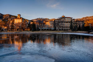
    I had the opportunity to stay at the Broadmoor Hotel in Colorado Springs, CO recently. The hotel is a Colorado landmark and one of the most ornate you’ll find. I especially like the setting with the Front Range foothills serving as a backdrop. A small pond divides the town wings of the hotel complete with 2 swans. A pretty sunrise make the hotel’s exterior glow a pinkish orange color in the morning sun. It’s always fun to stay at a landmark hotel like the Broadmoor and it was my first stay there despite living in Colorado most of my life. The hotel is located near many iconic spots like Pikes Peak, Garden of the Gods, and Cheyenne Canyon and the Cheyenne Mountain Zoo.

  • Fall Color Colorado 2021

    Fall Color Colorado 2021

    I traveled around a few points in the state of Colorado looking for fall color this past weekend. It has been a really nice fall with good weather for a change. No major snow or freeze to kill the color so far. I drove a lot of back roads. I started at the Castle Creek Road in Aspen and then drove over McClure Pass. Then I took Forest Road 250 around to Paonia and then went over Kebler and Ohio Passes near Gunnison and Crested Butte. Then due to the closure of Highway 50, I drove the North Rim of the Black Canyon. I even ended up at Vega Stat Park near Calhan.

    The fishing was also excellent. I caught 7 fish in limited time. I caught my first Cutbow (a mix of a cutthroat and rainbow), all six pounds of her. It was nice camping although I am not a fan of cattle grazing on the National Forest. I got kept awake by bellowing cattle most of the night. They also trashed the trail to the beaver pond.

  • East Inlet Trail Rocky Mountain National Park

    East Inlet Trail Rocky Mountain National Park

    I finally got a reservation to backpack the East Inlet Trail of Rocky Mountain National Park. Highlights include Adams Falls and a chain of five lakes. I made it to four of the lakes. My favorite was Spirit Lake. I also caught multiple brook trout in Lake Verna and Spirit Lake.

    Trail Description

    The trail starts out very easy. Adams Falls is accessed after about 1/3 mile on a short spur trail. It is a large cascade type waterfall. The trail continues east as it skirts the north side of a large meadow for about 2 miles. The trail here is nice and level but don’t be deceived. A steep trek awaits. About the 2.5 mile mark, you will pass the Lower East Inlet backcountry campsite. From here the trail begins to ascend steeply. Over the next mile you will learn to dread rock stairs because there are a ton of them. At the 3 mile mark, you will reach a large rock outcropping with a commanding view of Grand Lake to the west.

    The trail descends about 200 feet to join up with East Inlet Creek. The trail then mellows out for the next .5 mile or so until reaching Cat’s Lair campsite. Once again the trail climbs steeply through the forest and some fine cascades can be seen along the trail. At the 5.5 mile mark, you will reach Lone Pine Lake–the first in a chain of the five lakes. If you are not a strong backpacker, it is recommended to try and reserve one of the sites near this lake for the first night on the trail.

    After passing the lake, the trail once again ascends steeply through the granite slick rock face above the lake. There is a pretty waterfall shortly after passing the lake. The trail then ascends the steep cliff face on a long bench. This half mile is very steep. At the top of this stretch, you are rewarded with a commanding view of Lone Pine Lake, now about 500 feet below. The trail now follows the creek along a relatively flat street as it makes it way to Lake Verna. You will pass a small lake first that has been formed from a large rock fall damming the creek. At the 7 mile mark, you will reach Lake Verna. Here the maintained trail ends and you will have to follow the social trail to the next three lakes.

    Getting up the trail is challenging as many pines have been blown over and require constant scrambling and route finding. It is best to stay along the shore of lakes and by East Inlet Creek. Spirit Lake is next up and is located about .5 mile form the east shoreline of Lake Verna. Be sure to take in the afternoon sun on the nice beach on the east short of Verna first. The views begin to open up even more as you reach Spirit Lake. This is indeed a crown jewel of this chain. I hiked up to Fourth Lake but frankly it wasn’t;t worth the effort. It is a small marshy lake that is not as interesting. If you intend to reach Fifth Lake, you have to hike through more downed timber for the next 1/2 mile before reaching the open valley where Fifth Lake is located. It looked amazing up there but I was too tired by this point to head up.

    Trailhead Parking

    To access the East Inlet Trail, follow the main road into

  • Eccles Pass

    Eccles Pass

    Eccles Pass offers some panoramic views of the Eagles Nest Wilderness near Frisco, CO. I hiked up yesterday to catch the last of the wildflower show for 2020. Despite the haze from 4 wildfires burning in Colorado, it was a beautiful day and the wildflowers did not disappoint.

    To reach the summit of Eccles Pass requires just over a 5 mile hike. The Meadow Creek trail just outside of Frisco provides the primary access to the pass. The trail climbs through stands of aspen for the first mile as it works it way into the wilderness. The trail junction for the short trail to Lily Pad lake appears just after the .5 mile mark. Continue straight and follow the main trail as it quickly ascends through lodgepole pine. Around the 2 mile mark, the trail crosses Meadow Creek over a small bridge and then begins an arduous ascent along a rocky trail for the next 1.25 mile. The trail levels off at this point, and the forest transitions to spruce and fir. Around the 3.5 mile mark, the trail crosses the creek over some logs and limited views through the forest appear. At just over 4 miles, you reach a small beaver pond with dead pines along its shore. A good reflection of the mountains that ring the basin can be seen here. Continue on for about .5 mile and the views begin to open up around you. Shortly, you will come to a trail junction with the Gore Range trail. The faint trail to the left proceeds down to 10 Mile Creek. Go right to ascend the pass.

    This area used to contain a couple of large reflecting pools, but they are now unfortunately filled with grass. The last time I was up here, I photographed some beautiful reflections in the pools. Too bad they’re now history. The surrounding meadows are filled with wildflowers so there’s still beauty to take in, thankfully.

    After the steep climb to the summit of Eccles Pass, the trail drops into the valley below. There are a few small tarns and ponds as well as plenty of wildflowers to attract your eye. At this point, hikers have two options. Return the way you came or camp out in this lovely basin. Shuttle hikers can keep going over Red Buffalo Pass and will come out in East Vail. A side trip to the lovely Gore Lake is highly recommended for those doing this route.

  • Gore Lake

    Gore Lake

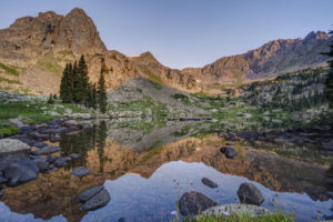
    Gore Lake is one of the prettiest in the Gore Range near Vail, CO. It also boasts some of the biggest trout you’ll see in an alpine environment. Which of course makes it a destination for any serious hiker, fisherman, or photographer. I happen to be all three so of course I had to visit the lake.

    The hike is 6.5 miles long and is steep in several sections. While arduous in spots, the nice thing about this trail it that it intersperses flat, level sections to allow you to catch your brief periodically. It begins at the Gore Creek trailhead off of the Big Horn Road near East Vail. The trail passes the junction with the Deluge Lake trail in about .25 mile and then climbs steeply up into the aspen forest. The aspen are dense for the first 1.5 miles and then give way to conifer forest. Around the 1.5 mile mark, the trail climbs a steep rocky section before crossing Deluge Creek over a bridge at the 2.5 mile mark. The trail passes through willow and several creeks cross the trail over the next mile. The trail now climbs steadily for the next half mile before flattening out on the approach to the trail junction at mile 5. Bear left to head to Gore Lake or stay straight if ascending the very steep Red Buffalo Pass.

    Bearing left to the lake you will pass a grave marker for two Swedes who died in the early 1900s. The next .75 mile is a lung and quad burner. It seems to head straight up the mountain in stretches. When you reach a small waterfall on your right, there is one last sharp incline before the trail flattens out in a lower meadow below the lake. You wander about .5 mile through a boggy environment as partial views of the mountains begin to open around you. Finally, the trail has one last steep section in store as it climbs the last 300 feet or so to Gore Lake over the last .5 mile. The climb is worth it as views of the peaks around the lake open all around. Look for the 18″-22″ cutthroat trout cruising the shallows of the lake. Then enjoy the fields of wildflowers to the south of the lake. This area boasts many good camping spots as well. Be sure to look for mountain goats in the area. I saw at a dozen watering about while I was there.

  • Crater Lake-Indian Peaks Wilderness

    Crater Lake-Indian Peaks Wilderness

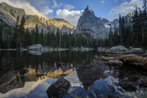
    The views from Crater Lake and Mirror Lake in the Indian Peaks Wilderness are some of the most iconic views in the Colorado mountains. I was excited to finally get a chance to see them on a recent backpacking trip with my sons. The area didn’t disappoint. Several fine waterfalls can be viewed along the Cascade Creek trail en route to the lakes. Both lakes are beautiful in their own right but the view from Mirror Lake with Lone Eagle Peak soaring behind it makes for a stunning photograph.

    The trail begins at the Monarch Lake trailhead at the back end of Granby Reservoir. It follows the north shoreline of Monarch Lake before entering the wilderness around mile 1.2. The trail reaches its first branch at mile 1.6 as the Arapaho Pass trail connects off to the right. Stay on the main trail and pass over Buchanan creek a bridge just over the 2 mile mark. The trail then begins to climb up switchbacks for a half mile or so before flattening out on its way to the junction with the Buchanan Pass trail. Bear right onto the Cascade Creek trail and cross over a bridge near the confluence of the two creeks. The trail climbs steeply to the first of many cascades. This one is notable for the narrow, rocky canyon it pours out from.

    The trail climbs again and you come to another bridge at 4.4 miles. Shortly thereafter, you come to the first of four cascades which comprise Cascade Falls. The trail becomes steep and rocky at this point as it winds its way past each of the four falls. The last one is located in an open valley at mile 5.2. The trail now opens into a large meadow filled with wildflowers in July. Several columbine paintbrush, and larkspur dot the hillside. This is a great spot for a rest as the trail begins a steep climb toward the junction with the Pawnee Pass trail. You reach the junction at mile 6.4. Pawnee Pass is to the left. Bear right and head toward the lake basin. The trail becomes very rocky here and quickly enters what looks like an abandoned stream bed. Climb up the narrow canyon and you come out atop a large rock slab. The area is marked with cairns.

    After a short jaunt through open forest, the trail again crosses Cascade Creek over a relatively new bridge at mile 7.4. You’re almost to Mirror Lake but you need to scale some switchbacks first. Finally, the epic view from the shore of Mirror Lake awaits around mile 7.8. Lone Eagle Peak’s pointed spire towers straight in front of you. If you’re spending the night, find an open campsite if you have the necessary reservation. There are 12 campsites in all between Mirror Lake and Crater Lake. Follow the trail to the left around the west side of the lake. It becomes very hard to follow in spots but just keep heading in this direction. Once you pass the far shore of the lake, you will come to a reflecting tarn with an amazing view of Lone Eagle Peak. Follow the trail around to the right and up over a large rock outcropping. Finally, you’ve reached the end of the trail at Crater Lake.

    I found sunset to be the the best time to shoot Mirror Lake but an hour after sunrise is also good. Crater Lake is best at sunrise.

  • Willow Lake-Sangre de Cristo

    Willow Lake-Sangre de Cristo

    My boys and I backpacked to Willow Lake in the Sangre de Cristo mountain range near Crestone, CO last weekend. It is a challenging hike, but the beautiful lake at the end of the hike makes it a rewarding one. It is surrounded by mountains in a narrow bowl including Kit Carson and Challenger peaks, two fourteeners. The trail climbs 2900 feet in 5 miles and is not for the faint of heart.

    The hike begins by climbing steadily up switchbacks through aspen and coniferous forest. After a mile, the switchbacks steepen as the trail climbs to a meadow (this is the second hardest portion of the hike). Views of Kit Carson peak open up here. Catch your breath as the next half mile is the only easy section of trail. The trail descends near the meadow and then begins a steady climb upward. More switchbacks await as you climb through the forest. Around the 2.5 mile mark, you will pass a large campsite on the left. The trail continues up switchbacks until leveling off briefly at a stream crossing at mile 3.5. Rest here and take in the pretty waterfall because the next half mile is the steepest of the trail. The trail climbs up through rock scree as it scales a sheer rock face. This section was as steep as any mountain pass I’ve climbed.

    The demoralizing aspect of the trail hits you in the last section. You’d think you’d be done after the last ascent, but there is still another mile to go with yes more switchbacks. You finally arrive at a meadow below Willow Lake where camping is allowed. No camping is allowed at the lake itself. The meadow will be crowded as climbers hiking Kit Carson and Challenger use it as a base camp.

    Finally, if you want to visit Willow Lake climb past the meadow on a steep, rocky path. A social trail through downed timber skirts some of the shoreline. Great views await at the lake with a waterfall draining into the back of the lake as an added bonus. The reflections in the lake were amazing near sunset. The only drawback is that very little of the surrounding mountains are lit with sunlight as the bowl faces diagonally and not much direct sunlight hits the basin. Also, don’t expect to find many fish in the lake. I saw only one brook trout.

    Getting There

    To reach the trailhead for Willow Lake (or South Crestone Lake), take Highway 17 to Moffat (between ALamosa and Salida) and turn east onto County Road T. Follow the road to the town of Crestone and then follow the signs for the Willow trailhead. A rough two mile dirt road takes you to the trailhead. A small parking lot holds about 30 cars, so be prepared to park down the road during busy days.

Plugin from the creators ofBrindes Personalizados :: More at PlulzWordpress Plugins