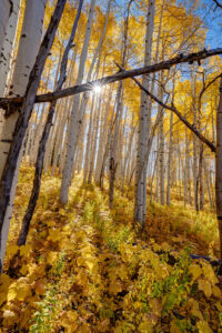
I took a drive near Steamboat Springs, CO to see the fall color this week. It was really vibrant this year with numerous reds and oranges interspersed amongst the normal yellow aspen. The weather was perfect, too. It was a great chance to try out my new Hasselblad X2dii. What an amazing camera!
Category: Colorado
-
Lake Charles, Holy Cross Wilderness
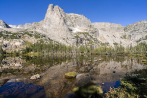
My son and I backpacked to Lake Charles in the Holy Cross Wilderness recently. The lake lies at the head of a glacial valley in the Holy Cross Wilderness near Eagle, CO. After spending the night at the lake, we hiked the mile up to Mystic Island Lake, another pretty lake in the chain.
The trail starts at the end of a Forest Service Road. It ascends steeply for about a quarter mile and then levels off for the next mile as it passes through aspen forest. It crosses a small boulder field around the 1 mile mark. Around 1.75 miles, you enter the Holy Cross Wilderness. You pass through a couple of small, marshy meadows. You will then pass small streams on the left and after the third stream, around the 2.75 mark, the trail begins to steadily gain elevation. Over the next 2 miles, the trail seems to relentlessly ascend the rocky terrain. The main stream will come back into view and the trail passes by some small cascades. Finally, you will reach the lake around the 5 mile mark. It is a sight to behold. The mountains soar above the lake. It is one of the prettiest valleys in Colorado.
The continues around the left side of the lake and then ascends about 200 feet to Mystic Island Lake. There is only a small steep section to reach the lake.
If you are patient, try your hand at catching the small cutthroat trout that live in both the lakes.
The weather was a mixed bag on the trip. It was humid on the hike in and then it poured after dinner as we were trying to set up camp. Nothing like water, mud, and pine needles coating a tent. The clouds parted just before sunset lighting up the mountains in the distance. A very special moment. The clouds cleared and I was treated to a star show and a great view of the Milky Way.
-

Odessa Lake Trail
This week I hiked to Odessa Lake in Rocky Mountain National Park, a place I’d never been before. The hike starts at the Bear Lake trailhead, passing Lake Helene, and ending up at Odessa Lake. It is a beautiful but challenging 8 mile RT hike.
The first part of the trail follows Bear Lake and then quickly veers uphill after .2 of a mile. The trail climbs above Bear Lake and then veers sharply to the left. The lake is 3.6 miles from this point. For the next .5 mile, the trail heads steeply uphill through the pine forest. At this point, another trail junction makes a sharp left (toward the summit of Flattop Mountain). Ignore this junction and continue heading straight. The trail continues to climb. Soon, you will pass a clearing where views of the Mummy Range open up to the north. You will come to a large boulder field and avalanche chute that provides more open views.
The trees begin to thin at this point and views of the mountains to the west appear. The trail through this section is quite easy. The grade is only a gentle uphill slope. As views of the mountains open up, the trail makes a hard right turn. At this point (around mile 3.5), a small social trail to the left is visible. Take this trail and after .2 mile, Lake Helene awaits. It is willow choked around the shore but a few spots are accessible. Follow the indistinct social trail to the left and visit some of the open spots along the lake. Lake Helene is quite shallow so the reflections are amazing here.
After rejoining the main trail, continue heading north on the trail if you want to visit Lake Odessa. Here’s the bad news–the trail descends quite steeply about 600-800 feet to reach the lake. This means you will have to climb this steep and rocky slope on the return unless you through-hike to the Fern Lake trailhead and catch the shuttle back to Bear lake (this adds about 1-1.5 miles to the total hike). Odessa Lake is visible in a couple of spots as you descend. The trail passes the lake before backtracking to the shoreline.
Enjoy lunch at the lake! You will need to recharge your batteries before the steep uphill climb back to Lake Helene. This part of the trail took me about 45 minutes. Once you reach this spot, however, it all downhill from here. The entire hike takes about 5-5.5 hours.
-
Pitkin Lake
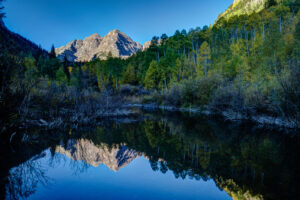
It had been about 25 years since I had been up to Pitkin Lake in the Eagles Nest Wilderness near Vail so I decided to go back this past week. Pitkin Lake is a beautiful place. The hike features a couple of waterfalls, wildflower-filled meadows, and soaring peaks. What’s not to like? The steepness of the hike, for one. This is a challenging backpack. Although the trail is listed at 4.8 miles, the trek is far longer. It gains 3,000 vertical feet and takes about 4.5 hours and about 3.75 hours going down. My guess is this hike is closer to 5.7 miles each way, almost 2 miles longer roundtrip than advertised.
The trail starts in East Vail by crossing Pitkin Creek almost immediately. Then the fun begins, It climbs steeply over the next .5 mile, gaining about 500 feet in elevation in the process. The trail mellows out a little but and then gets pretty flat as it wanders through aspen trees. At mile 1.9 (or 2.7 in actual distance), the trail provides an overlook of a large waterfall off to the right. From here, the trail ascends at a steep incline for the next 1.5 miles before it reaches a second waterfall, this time on the left. This stretch of trail left my quads burning and required a couple of breaks. It flattens out thankfully just before coming to a second waterfall at around mile 3.5 (4.3). Access is limited due to rocks and willows. I could not get a decent photo of it. Past the waterfall, the trail ascends steeply to the right of the waterfall and then alternates steep sections with flatter ones. The trail is quite marshy through this section and is quite mosquito-filled. Finally, the trial opens up into a beautiful meadow. The flowers were just beginning to pop in this section.
Once you get to the lake, all is forgiven, however. It is a serene setting. Colorado cutthroat trout inhabit the lake and my son and I caught a couple. /we saw no none else camped in the basin which was amazing.
Getting to the trialhead
Parking is limited at this trail. There are about 20 spots but they are limited to three hours (not enouh time to do even half the trail). The best course is to park near the vail transit center and catch the free East Vail hiker express. The shuttle makes a few stops at the most popular trailheads. The one for this hike is Falls at Vail. The shuttle stop is about a .25 mile downhill from the trailhead. If you are backpacking and need overnight parking, the Redstone parking garage in West Vail is your best bet. It costs $15 for the night (as opposed to $30 in the lot by the transit center). You will need to walk an additional mile to get to this garage or catch the free shuttle from the transit center.
-

Pear leaves
I walked around the neighborhood today taking pictures of the last vestiges of fall color. Some pear trees and one oak still had some leaves left. I used my 85mm to blur the background on a handful of shots. I like how the background melts away with this lens.
-

Fall Color Steamboat 2023
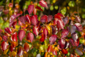
It was a beautiful fall in Steamboat Springs, CO this year. All of the winter snow paid dividends this fall.
-
Crested Butte Wildflowers 2023
I took a quick trip to Crested Butte to check out the wildflowers this year. The flowers weren’t as ever-present as they have been in the past but in areas that had them they were in abundance. Some of the fields of lupine and Mules Ears were resplendent. I was even treated to a sunset lighting up Marcelina Mountain at the end of the evening. The areas with the most flowers seemed to be one hillside at the start of the Brush Creek Road and then the very start of the Gothic Road leading into the East River Valley just north of town. I did not see as many flowers around the Slate River Road as I had see in the past. But all in all, this appears to be a good year for flowers in Colorado. I can’t wait to check out the high alpine flowers over the next couple of weeks.
-

Maroon Bells Fall Foliage
I reserved a parking space at the Maroon Bells to park at Maroon Lake. Unfortunately, two circumstances made photography challenging. One, the fall is a week late this year due to excess moisture during the summer. Only about 25% of the aspen had turned. Two, Maroon Lake is way low. I don’t know if it is beavers of releasing the water due to water compacts but the classic reflection shot of Maroon Lake is now impossible. Only about half the lake remains and the forest service has roped off the path and required to stay on it so access is about 50 feet from the water. The area is still beautiful but the iconic shot I fear is a thing of the past here. Luckily, the parking reservation system has limited crowds. I look forward to mid week when I can get back up in the high country to photograph the aspen.
-
Dream Lake Loop
I hiked a loop from Bear Lake parking lot in Rocky Mountain National Park yesterday. I photographed the sunrise at Dream Lake and then ventured over the hill to Lake Hiyaha about 1 mile away. Although virtually at the same elevation, the two lakes are separated by a large hill that must be scaled. So the trail ascends and descends steeply form Dream Lake. Lake Hiyaha has a weird green mile color right now due to glacial sediment being disturbed. The lake itself is not very photogenic due to the presence of large boulders all along its shoreline. The tarn just in front of the lake was more photogenic in my mind. I then hiked the connector trail with the glacial gorge trail. About half a mile from the junction, there are two small tarns that are quite photogenic. I did get wet getting to the shore of one, however. It is quite the bog!
-
Ptarmigan Lake
My son and I backpacked to Ptarmigan Lake near Cottonwood Pass last week. The lake is above treelike in a small valley in the Collegiate Peaks wilderness. The hike itself is relatively short which makes for a fun out and back. We were treated to a beautiful sunset.
To reach Ptarmigan Lake, drive 14 miles west of Buena Vista on Rd 306 (Cottonwood Pass). There is a sign for the parking lot on the left.. Hike south through the forest for 2 miles. The trail climbs steeply at first for the first 1/2 mile and crosses a couple of boulder fields. The levels off some over the next 1.5 miles. Around mile 2 it climbs a couple of switchbacks and you finally have some views of the surrounding mountains. A small tarn is on your right and a lake is off to the left. Continue for about 3/4 mile past the small tarn on the right before steeply ascending the last 300 feet to Ptarmigan Lake. There are several small tarn and lakes in this area. I found the one just to the left of Ptarmigan Lake to be the prettiest. You are above treelike here so caution may be warranted if storms are in the area.