Category: Colorado

  • Willow Lake-Sangre de Cristo

    Willow Lake-Sangre de Cristo

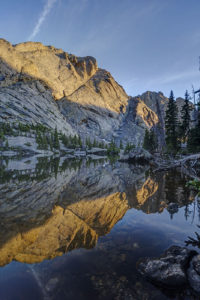
    My boys and I backpacked to Willow Lake in the Sangre de Cristo mountain range near Crestone, CO last weekend. It is a challenging hike, but the beautiful lake at the end of the hike makes it a rewarding one. It is surrounded by mountains in a narrow bowl including Kit Carson and Challenger peaks, two fourteeners. The trail climbs 2900 feet in 5 miles and is not for the faint of heart.

    The hike begins by climbing steadily up switchbacks through aspen and coniferous forest. After a mile, the switchbacks steepen as the trail climbs to a meadow (this is the second hardest portion of the hike). Views of Kit Carson peak open up here. Catch your breath as the next half mile is the only easy section of trail. The trail descends near the meadow and then begins a steady climb upward. More switchbacks await as you climb through the forest. Around the 2.5 mile mark, you will pass a large campsite on the left. The trail continues up switchbacks until leveling off briefly at a stream crossing at mile 3.5. Rest here and take in the pretty waterfall because the next half mile is the steepest of the trail. The trail climbs up through rock scree as it scales a sheer rock face. This section was as steep as any mountain pass I’ve climbed.

    The demoralizing aspect of the trail hits you in the last section. You’d think you’d be done after the last ascent, but there is still another mile to go with yes more switchbacks. You finally arrive at a meadow below Willow Lake where camping is allowed. No camping is allowed at the lake itself. The meadow will be crowded as climbers hiking Kit Carson and Challenger use it as a base camp.

    Finally, if you want to visit Willow Lake climb past the meadow on a steep, rocky path. A social trail through downed timber skirts some of the shoreline. Great views await at the lake with a waterfall draining into the back of the lake as an added bonus. The reflections in the lake were amazing near sunset. The only drawback is that very little of the surrounding mountains are lit with sunlight as the bowl faces diagonally and not much direct sunlight hits the basin. Also, don’t expect to find many fish in the lake. I saw only one brook trout.

    Getting There

    To reach the trailhead for Willow Lake (or South Crestone Lake), take Highway 17 to Moffat (between ALamosa and Salida) and turn east onto County Road T. Follow the road to the town of Crestone and then follow the signs for the Willow trailhead. A rough two mile dirt road takes you to the trailhead. A small parking lot holds about 30 cars, so be prepared to park down the road during busy days.

  • Boulder Spring Snow

    Boulder sets its all-time record for snowfall in a winter with this past storm. The spring snow storm dumped 15 inches on the city bringing the annual total to 151 inches. April has been a very snowy month so far. It was a beautiful morning to be outside despite the 5 degree temperatures. I am not a big fan of spring snow, but I know the snow is great for the plants. Can’t wait for the wildflowers to show up in June!

  • Red Rock Lake Sunrise

    I finally decided to do some snowshoeing this winter. I went up to the Brainard Lake Recreation area in the Indian Peaks Wilderness. First, I stopped at Red Rock Lake to catch the sunrise. I had been meaning to do this for a number of years but had never gotten around to it. I picked a good morning to come. The color was intense–unfortunately, so was the wind. It had to have been blowing 50 mph. It knocked over my tripod on a couple of occasions (luckily without my camera on it). The sunrise was a rosy red and purple to the east and then the rising sun lit up the mountains behind Red Rock Lake. I then hiked up to Lefthand Reservoir. The view was noice but the clouds were really rolling in by then. What a special morning.

  • Colorado Fall Color 2019

    I spent 4 days in the Colorado high country last week. The aspen were at peak or just beginning to turn in some places. Grand Mesa and Boreas Pass were the best spots to catch fall color.

    Aspen

    Maroon Bells had some nice aspen but the area was not at peak yet. The water in Maroon Lake was unusually low so it made for bad reflection photos. I did get to see a beautiful sunrise at the start of the Capitol Peak trail.

    Grand Mesa

    I found a couple of nice spots to see fall color on the Grand Mesa near Grand Junction, CO. The best seemed to be around Lake.

    Boreas Pass

    The aspen were turning near peak color last weekend on Boreas Pass near Breckenridge.


    Flattops

    I took a drove through the flattops. While the aspen had not yet turned, the scrub oak were amazingly vibrant.

  • Herman Gulch in Moonlight

    I backpacked the short 3 mile trip to Herman Lake near Loveland ski area so I could photograph the mountains in the light of the full moon. The area has a small tarn that reflects the area’s main peaks in it as well as featuring large fields of wildflowers. What could be a more perfect spot to capture the stars and landscape in the light of a full moon?

    I camped near the tarn and found a large field of red paintbrush close by. This made for some drastic sunset shots with the peaks providing a beautiful backdrop. Then the moon came up, illuminating the peaks above Herman Lake. What a sight! There were a lot of clouds still hanging around which made it tricky to photograph. I was using an exposure of 15 seconds at f 5.6 for the photos. The clouds blurred out from the long exposure but also periodically blocked the moon. It was challenging but amazing lighting for sure. An added bonus–I was the only person in the vicinity of the lake for this full moon show. What a feeling!

    Trail Description

    The hike to Herman Lake begins at the trailhead just off I-70 at exit 218. It starts moderately but then steeply ascends through the forest along the creek after about .25 mile. It then pops out of the forest after a mile and passes several fields of columbine as the trail meanders through the open meadow. The trail begins to ascend steeply again about the 2.5 mile mark. The trail reenters the forest and hikers have to negotiate several patches of exposed tree roots. Finally, it exits the trees for good at around mile 3 and ascends the last couple of switchbacks to the lake.

  • Gilpin Lake/Gold Creek Lake Loop

    I backpacked the Gilpin Lake/Gold Creek Lake loop in the Mt. Zirkel Wilderness otherwise known as the Zirkel Circle over the 4th of July. The trail is strenuous at times but provides some wonderful views and beautiful scenery for most of the hike. The NFS lists the distance for the loop at 11 miles but it is at least 2 miles longer than advertised so be prepared if you hike the entire loop.  I chose to hike the loop from Gilpin Lake to Gold Creek. The trail up to Gilpin Lake is generally steeper but converts the long uphill section from the trail junction  if you go the other way to a downhill section.  I started out from the Slavonia trailhead about 20 miles north of Steamboat Springs. I reached a trail register and the trail junction with the Gold Creek trail after .1 mile.  I signed in and headed left up to Gilpin Lake.  The first part of trail rambles through aspen forest.  A few large clumps of paintbrush grew close to the trail.  My next milepost was the wilderness boundary at 1.6 miles.  The trail follows a creek through open meadows and a wide glacial valley at this point. Hundreds of columbine were blooming near the trail at around the 2.5-3 mile mark. The trail climbs steadily but not too steeply thorough most of this stretch. Finally, I reached a stream crossing at around mile 5. From here, you been a steep ascent to Gilpin Lake over the next .75 mile. There is really no good camping spots from the water crossing to the lake due to the steepness of the terrain.  Finally, I reached Gilpin Lake after 4 hours of hiking.

    Gilpin Lake is one of the jewels of the Rocky Mountains. It surrounded almost entirely by mountains.  The lake is relatively shallow which made for great reflection shots at sunset and sunrise. I wandered around the near shore of the lake and found a primitive trail that led down the back side of the lake past the outlet. Some beautiful cascades can be found here. I set up my tripod on the far side of the lake and waited for sunset.  I was not disappointed. The mountains above the lake glowed red in the setting sun, aided by smoke in the air from forest fires burning in southern Colorado. I also cast out a fishing line and snagged a couple of small brook trout while I took int he view. In the morning, I walked along the east side of the lake and watched the sun light up the peaks to the south. What an amazing scene.

    Around 8:30, I headed up to the saddle above Gilpin Lake. It its a steep, half-mile ascent to the saddle but not nearly as bad as some passes in Colorado can be. The view from the top is spectacular.  Big Agnes mountain looms large behind the lake when viewed from this direction. I then headed down the pass toward the Gold Creek trail. This is a long, steep descent as previously noted.  After about a mile, I came to the junction with the Gold Creek trail. The trail then follows the creek down valley to the right. Gold Creek is a narrower, tree-filled valley. The shade was welcome given the heat of the day beginning to build. I came to Gold Creek Lake after 2 miles. It is a pretty, forested lake. It has excellent fishing for brookies, BTW. The long slog bak to the trailhead now begins. The trail descends along Gold Creek and passes a couple of large waterfalls.  There are also a couple of difficult stream crossings along the way. There are logs but if you don;t like the tight rope act with a pack on, wading might be the better option. On one of them, I ended up fighting a fir tree near the start. After a seemingly endless 4 mile hike, I reached the trailhead, exhausted.

    Directions to the trailhead. 

    Drive 18 miles north of Steamboat on RD 129. Then turn right onto Seedhouse Road.  Drive 12 miles along the half paved, half dirt road to the end to reach the Slavonia trailhead.  Trail 1161 leads to Gilpin Lake.   Although many people hike the trail, few backpack it.  Solitude can be found while camping.  One word of caution. Camping is restricted 1/4 from the lake. You’ll have to head out a ways from the trail to find camping spots.   

  • Sky Pond

    I hiked to Sky Pond in Rocky Mountain National Park earlier this week.  The lake lies at the foot of the Sharksteeth, some jagged mountains near the Continental Divide in Rocky Mountain National Park. Along the way, there are numerous waterfalls to see and a couple of beautiful lakes. The trail starts at the Glacier Gorge trailhead off the Bear Lake Road.  I got to the trail at 6:30 so I was able to find parking in the small lot.  The first big attraction on the trail is Alberta Falls. The sun was just peeking over the canyon rim at 7:00 so it was luckily still in shade.  I snapped a quick photo and then headed up the trail about 1.2 miles to where it divides with the Mills Lake trail. I veered right toward the Loch. The trail climbs steeply up some switch backs before reaching the lake in about .7 of a mile. The Loch is a pretty lake which often has nice reflections on it. It also had some nice trout surfacing so wish I had had my pole with me. I hiked onward about a mile until I came to Timberline Falls.  The last .5 mile of trail went up some steep rock stairs to reach the falls. I love Timberline Falls. It is one of the prettiest waterfalls in the park. I climbed down below the first part to take in the whole falls.  What a scene with the pure blue sky behind it. I then had to scramble up the right side of the falls. This isn;t normally a hard scramble but the falls were high so I got a little wet navigating them this time around. Once over the falls, I took in the scene of Lake of Glass. With the breeze picking up, it didn’t have much of a reflection per its namesake, but it was still very scenic. I then climbed above the lake to the right up in the rocks and made it the last 1/2 mile to Sky Pond. There aren;t too many lakes prettier in Colorado, that’s for sure.

  • Rogers Peak Lake

    I backpacked to Rogers Peak Lake in the James Peak Wilderness near Rollinsville, CO.  The lake sits at treeline in a beautiful valley near the East Portal train tunnel.   Rogers Peak is a pointed mountain that frames the south east side of the lake.  The hike to get to the lake is about 4.5 miles.  It is moderate climb from the trailhead until the last mile when the trail begins to climb steeply up to the basin.  

    Trail Description

    The trail begins rather easily as it parallels the railroad tunnel. At about 1/2 mile, the trail divides.  The fork to the right leads to Forest Lakes.  After a mile, the trail enters the forest and begins to climb up a rocky embankment.  You catch glimpses of the pretty South Boulder Creek through the trees.  Around 2 miles, the trail forks again.  The right fork leads to Crater Lake trail.  Around three miles, the trail crosses South Boulder Creek and climbs steadily to the lake from here.  The trail crosses several boggy spots and is lined with tree roots in this section.   The trees thin around mile 4 and the lake is close at hand.  Camping is plentiful below the lake, just a past a small tarn to the left.  Once at the lake, the trail continues up to Rogers Lake Pass or diverts to Heart Lake. 

    Rogers Peak Lake contains several species of trout and offers decent fishing for sizable fish.  I caught three brook trout.  The lake is good for photography both at sunrise and sunset.  It’s also a good place to see the Milky Way.

    Getting There

    Take Highway 119 from Boulder to Nederland and turn south.  Go 5 miles to Rollinsville and turn right onto a dirt road to the East Portal. Go 8 miles to the trailhead. 

  • Missouri Lakes

    I backpacked into Missouri Lakes basin in the Holy Cross Wilderness in Colorado.  I intended to complete the loop with Fancy Pass but too much snow at the top of the pass.  I got hailed on twice but it was worth the effort.  I saw an amazing sunset and the alpenglow on the mountains was stunning this morning.  The basin has three large lakes and a number of small tarns that make for great reflection photography.  I even caught a couple of brook trout out of the middle Missouri Lake.  En route to the lakes, a number of cascades and waterfalls make the hard hike an enjoyable one.  

    Trail Description

    The trail starts at the Missouri Lakes trailhead after an 11 mile drive on Forest Service roads.  It begins gently as the trail parallels the creek.  After a half a mile it begins to ascend more steeply.  At around one mile, you are treated to a beautiful double waterfall.  Unofruntately, there is no way to get close to the falls as the area is surrounded by dense undergrowth.  Just ahead, a little pond is a good place to stop and grab a snack.  From here, the trail begins ascending steeply and the trail becomes rocky.  Cascade after cascade can be seen along the creek.  At one point, the trail crosses the creek.  Here, a the creek cascades through a granite gorge. The trail levels out monetarily as it crosses a boggy meadow.  The trees start to thin as you approach Missouri Lakes basin.  The first lake soon comes into view around mile 3.  A number of small tarns can be found off trail just before the lake.  A number of good camping sites can be found in this area.  After passing the first lake, the trail makes a hard right turn up the hillside and the second lake can be found about 200 feet higher.  The trail passes the second lake and the third lake comes into view on the left.  For those wanting to take in the view, the trail climbs very steeply up to the pass.  Snow will remain here into August this year it looks like.  


  • King Lake

    The long hike to King Lake in the Indian Peaks Wilderness is worth the effort.  Near the end, you are rewarded with great views, rushing water, and abundant wildflowers.  Getting there requires a 6.5 mile hike from the Hessie Trailhead near Nederland, CO.  The trail begins steeply as it climbs over a rocky slope before reaching a trail divide after 1.5 miles.  Veer left (the right branch goes toward Jasper Lake). The trail crosses the creek and climbs past a beautiful waterfall.  You reach a trail divide again at mile marker 2.5.  Keep straight.  Then the trail enters the forest and climbs only gradually for the next three miles.  Not many views are found during this portion of the hike. Finally, the trail joins up with the creek again at around mile 5.5.  The next mile is steep as it switch backs up to a meeting with the Betty and Bob Lakes trail.  Just past the junction you have to cross the creek to reach King Lake.  In high water, the creek can be crossed easier to the right and then skirting back to the trail through some large boulders.  Finally, after a long hike, you reach the pretty shores of King Lake.  


Plugin from the creators ofBrindes Personalizados :: More at PlulzWordpress Plugins