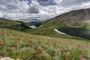
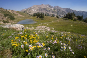
It is wildflower time in Colorado. The peak is just about past but there is still time to get out and enjoy the flowers. I did a short hike to Silver Dollar Lake and Murray Lake near the summit of Guanella Pass. The paintbrush were going crazy in the meadow between the two lakes. The hike itself is relatively short but is steep in sections. It is about 5 mile roundtrip. Most of it is above treeline as well. The views are amazing but oxygen is in short supply. The trail meanders through the forest for about 1.2 mile before veering left. It then switchbacks steeply above the private lake to your right. The flowers start in earnest along drainage areas about halfway up the trail. Enjoy!
Red paintbrush, Silver Dollar Lake, near Guanella Pass, CO,
Wildflowers, Silver Dollar Lake trail, near Guanella Pass, CO
Lake Murray, Silver Dollar Lake trail, Guanella Pass, CO
To get to the Silver Dollar Lake trail, take the Guanella Pass road out of Georgetown, Colorado. Head south until reaching the campground near the summit. The turn for the trailhead is just past the campground and just before a steep switchback in the road. A parking area is on the right. Vehicles with a little clearance can easily make the higher parking lot about .75 mile up the road. Park before you reach the Naylor Lake lodge.
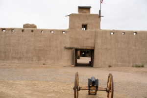
On a rainy day while camping, my son and I decided to visit Bent’s Fort near Las Animas in southeastern, CO. The fort has been restored to the original version based on drawings of a military officer who stayed there in the 1840s. The original fort burned down in 1849. It is an interesting place to visit. It gives you a feel of the old southwest and it is an oasis of green in an otherwise dry area. Its position along the Arkansas River creates a good environment for the cottonwoods and cattails surrounding the fort.
My son and I camped at Pueblo Reservoir about 70 miles to the west. We caught a beautiful sunset there as well. Amazingly, the rain held off at Bent’s Fort as it rained for 9 straight hours just to the east of there.
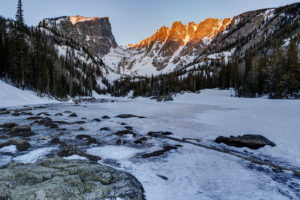
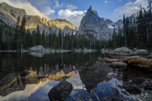
One of my favorite places to visit in Rocky Mountain National Park in winter is the trail to Dream and Emerald Lakes. The first light hits the mountains behind the lakes at just the right angle at sunrise while it takes several minutes longer to hit the peaks in other nearby valleys. I snowshoed up the short mile-long trail this week to catch the sunrise. I was not disappointed. I got good color on the peaks and even had some clouds to make for good color in the sky. I even stopped to shoot some macros of the ice on Dream Lake. The fierce winds in this area make for some spectacular patterns in the ice.
Dream Lake, sunrise, Rocky Mountain National Park, CO
Emerald Lake, sunrise, Rocky Mountain National Park, CO
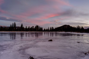
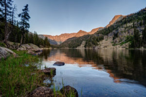
I ventured up to Sprague Lake in Rocky Mountain National Park yesterday to check out the sunrise. While the sun take a while to hit the peaks directly in back of the lake the color in the sky during a winter sunrise is spectacular. I was one of only two people at the lake so it was a peaceful, serene setting to take in a pretty sunrise as well. Since it is located off the Bear Lake road, Sprague Lake can be overrun with tourists in the summer so it was a welcome change to see so few people there.
Sunrise, Sprague Lake, Rocky Mountain National Park, CO
The Flattops wilderness in western Colorado is one of the best places to see fall color in Colorado. There are large aspen forests seemingly all through the wilderness. I recently drove from New Castle to Buford and then across the Flattops on County Road 8 to Yampa. I also drove a long section of the Deep Lake ROad near Dotsero. Despite dire predictions of a poor fall in the northern half of the state due to lack of moisture, the colors are some of the best I’ve seen in recent memory. Ripple Creek and Dunkley Passes were both particularly vibrant. I even saw a beautiful sunset atop Ripple Creek Pass. The trees have turned about 50% and many are still green so hopefully the show will last another 7-10 days.
A word of caution should be issued. Wear bright colors if you go. Fall is hunting season and the Flattops is full of hunters this time of year.
Getting there:
There are several roads into the Flattops. County Road 8 runs between Yampa and Meeker for about 75 miles. A detour to Trappers Lake can be made about 30 miles from the Meeker end. Roads also run to Deep Lake (5 miles north of Dotsero) and YamColo Reservoir (also from the Yampa end).
Fall color, Flattops Wilderness, CO
Fall color, Ripple Creek Pass, Flattops Wilderness, CO
Fall color, Flattops Wilderness, CO
Fall color, sunset Ripple Creek Pass, Flattops Wilderness, CO
Fall color, sunset, Ripple Creek Pass, Flattops Wilderness, CO
Fall color, sunset Ripple Creek Pass, Flattops Wilderness, CO
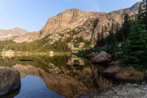
I backpacked to Pear Lake in the southern most part of the Wild Basin area of Rocky Mountain National Park yesterday. Pear Lake is a beautiful alpine lake and apart from the scenery offers the chance to catch native greenback cutthroat trout.
Getting to Pear Lake is something of a challenge. The lake can be reached via three different trailheads (Wild Basin, Allenspark, and Finch Lake), the shortest of which is just over 6 miles. I choose to depart from the Finch Lake trailhead, putting the trek at 6.5 miles. This trail is the most physically challenging of the three. Immediately, the trail soars 800 feet in the first .8 miles along a narrow, rocky trail. No switchbacks here as the trail climbs unrelentingly until it reaches a small saddle. The trail then meanders through a large aspen forest and wildflower meadow, a rare treat in Rocky Mountain. This is a chance to catch your breath for the next ascent. Just after intersecting with a spur of the Allenspark Trail about 1.8 miles in, the trail climbs steadily again, this time up a series of rock stairs. Just who thought it was a good idea to use 1.5 foot tall boulders as trail building material? Needless to say, this section presents a grueling uphill section.
At mile 2.5, the trail comes to a Y with the Allenspark trail and a connector to the Calypso Cascades. Over the next two miles, the trail continues to ascend but at a much more gradual pace. After some pretty views of Mount Meeker and Long’s Peak in the distance, the trail enters the forest and is fairly nondescript. Just before the 4 mile mark, the trail takes a steep descent of 300 feet into the Finch Lake basin. Nothing bad about a descent except that this section has to be climbed on the return. Finch Lake sits at 4.5 miles along the trail. It is a pretty lake surrounded by forest with a couple of peaks poking up in the distance. Follow the trail to the right as it crosses the creek and then ascends again. This section is steep but thankfully short. After reaching a lily pad pond in another mile or so, the trail flattens out before making one last ascent into the Pear Lake basin.
Here is the reward for this hard hike. Pear Lake is surrounded by mountains and is one of the prettiest in the park. It used to be much larger thanks to an earthen dam but the dam has since been removed. The lake is now about 30 feet less wide and about 6 feet less deep. And yes, there is still evidence of a bathtub ring even after the dam was removed in 1988. The lake holds a small but feisty collection of Greenback Cutthroat trout. I managed to hook a half dozen or so in my couple hours of fishing. They ranged in size from 3″ to 11″. There is one campsite above the lake which I was lucky enough to snag in the backcountry lottery in March. Photography is best here in the morning. Because Pear Lake is situated nearly east to west, the sun disappears two hours before sunset. Conversely, almost the entire lake was in sunshine just after sunrise.
Mariposa Lily, Pear Lake trail, Rocky Mountain National Park, CO
Indian Paintbrush, Pear Lake trail, Rocky Mountain National Park, CO
Columbine, Pear Lake, Rocky Mountain National Park, CO
Moonlit Pear Lake, Rocky Mountain National Park, CO
Moonlit Pear Lake, Rocky Mountain ‘n’ational Park, CO
Pear Lake, Rocky Mountain National Park, CO
Lily pond, Pear Lake trail, Rocky Mountain National Park, CO
Finch Lake, Rocky Mountain ‘n’ational Park, CO
Mountain View, Pear Lake trail, Rocky Mountain ‘n’ational Park, CO
I finally got a reservation to backpack the East Inlet Trail of Rocky Mountain National Park. Highlights include Adams Falls and a chain of five lakes. I made it to four of the lakes. My favorite was Spirit Lake. I also caught multiple brook trout in Lake Verna and Spirit Lake.
Trail Description
The trail starts out very easy. Adams Falls is accessed after about 1/3 mile on a short spur trail. It is a large cascade type waterfall. The trail continues east as it skirts the north side of a large meadow for about 2 miles. The trail here is nice and level but don’t be deceived. A steep trek awaits. About the 2.5 mile mark, you will pass the Lower East Inlet backcountry campsite. From here the trail begins to ascend steeply. Over the next mile you will learn to dread rock stairs because there are a ton of them. At the 3 mile mark, you will reach a large rock outcropping with a commanding view of Grand Lake to the west.
The trail descends about 200 feet to join up with East Inlet Creek. The trail then mellows out for the next .5 mile or so until reaching Cat’s Lair campsite. Once again the trail climbs steeply through the forest and some fine cascades can be seen along the trail. At the 5.5 mile mark, you will reach Lone Pine Lake–the first in a chain of the five lakes. If you are not a strong backpacker, it is recommended to try and reserve one of the sites near this lake for the first night on the trail.
After passing the lake, the trail once again ascends steeply through the granite slick rock face above the lake. There is a pretty waterfall shortly after passing the lake. The trail then ascends the steep cliff face on a long bench. This half mile is very steep. At the top of this stretch, you are rewarded with a commanding view of Lone Pine Lake, now about 500 feet below. The trail now follows the creek along a relatively flat street as it makes it way to Lake Verna. You will pass a small lake first that has been formed from a large rock fall damming the creek. At the 7 mile mark, you will reach Lake Verna. Here the maintained trail ends and you will have to follow the social trail to the next three lakes.
Getting up the trail is challenging as many pines have been blown over and require constant scrambling and route finding. It is best to stay along the shore of lakes and by East Inlet Creek. Spirit Lake is next up and is located about .5 mile form the east shoreline of Lake Verna. Be sure to take in the afternoon sun on the nice beach on the east short of Verna first. The views begin to open up even more as you reach Spirit Lake. This is indeed a crown jewel of this chain. I hiked up to Fourth Lake but frankly it wasn’t;t worth the effort. It is a small marshy lake that is not as interesting. If you intend to reach Fifth Lake, you have to hike through more downed timber for the next 1/2 mile before reaching the open valley where Fifth Lake is located. It looked amazing up there but I was too tired by this point to head up.
Trailhead Parking
To access the East Inlet Trail, follow the main road into
East Inlet Trail, Rocky Mountain National Park, CO
Lake Verna, East Inlet Trail, Rocky Mountain National Park, CO
East Inlet Creek, East Inlet Trail, Rocky Mountain National Park, CO
Lake Verna, East Inlet Trail, Rocky Mountain National Park, CO
Eccles Pass offers some panoramic views of the Eagles Nest Wilderness near Frisco, CO. I hiked up yesterday to catch the last of the wildflower show for 2020. Despite the haze from 4 wildfires burning in Colorado, it was a beautiful day and the wildflowers did not disappoint.
To reach the summit of Eccles Pass requires just over a 5 mile hike. The Meadow Creek trail just outside of Frisco provides the primary access to the pass. The trail climbs through stands of aspen for the first mile as it works it way into the wilderness. The trail junction for the short trail to Lily Pad lake appears just after the .5 mile mark. Continue straight and follow the main trail as it quickly ascends through lodgepole pine. Around the 2 mile mark, the trail crosses Meadow Creek over a small bridge and then begins an arduous ascent along a rocky trail for the next 1.25 mile. The trail levels off at this point, and the forest transitions to spruce and fir. Around the 3.5 mile mark, the trail crosses the creek over some logs and limited views through the forest appear. At just over 4 miles, you reach a small beaver pond with dead pines along its shore. A good reflection of the mountains that ring the basin can be seen here. Continue on for about .5 mile and the views begin to open up around you. Shortly, you will come to a trail junction with the Gore Range trail. The faint trail to the left proceeds down to 10 Mile Creek. Go right to ascend the pass.
This area used to contain a couple of large reflecting pools, but they are now unfortunately filled with grass. The last time I was up here, I photographed some beautiful reflections in the pools. Too bad they’re now history. The surrounding meadows are filled with wildflowers so there’s still beauty to take in, thankfully.
After the steep climb to the summit of Eccles Pass, the trail drops into the valley below. There are a few small tarns and ponds as well as plenty of wildflowers to attract your eye. At this point, hikers have two options. Return the way you came or camp out in this lovely basin. Shuttle hikers can keep going over Red Buffalo Pass and will come out in East Vail. A side trip to the lovely Gore Lake is highly recommended for those doing this route.
Reflecting tarn, Meadow Creek Trail, Eagles Nest Wilderness, CO
Wildflowers, near Eccles Pass, Eagles Nest Wilderness, Frisco, CO
Reflecting tarn, near Eccles Pass, Eagles Nest Wilderness, Frisco, CO
Gore Lake is one of the prettiest in the Gore Range near Vail, CO. It also boasts some of the biggest trout you’ll see in an alpine environment. Which of course makes it a destination for any serious hiker, fisherman, or photographer. I happen to be all three so of course I had to visit the lake.
The hike is 6.5 miles long and is steep in several sections. While arduous in spots, the nice thing about this trail it that it intersperses flat, level sections to allow you to catch your brief periodically. It begins at the Gore Creek trailhead off of the Big Horn Road near East Vail. The trail passes the junction with the Deluge Lake trail in about .25 mile and then climbs steeply up into the aspen forest. The aspen are dense for the first 1.5 miles and then give way to conifer forest. Around the 1.5 mile mark, the trail climbs a steep rocky section before crossing Deluge Creek over a bridge at the 2.5 mile mark. The trail passes through willow and several creeks cross the trail over the next mile. The trail now climbs steadily for the next half mile before flattening out on the approach to the trail junction at mile 5. Bear left to head to Gore Lake or stay straight if ascending the very steep Red Buffalo Pass.
Bearing left to the lake you will pass a grave marker for two Swedes who died in the early 1900s. The next .75 mile is a lung and quad burner. It seems to head straight up the mountain in stretches. When you reach a small waterfall on your right, there is one last sharp incline before the trail flattens out in a lower meadow below the lake. You wander about .5 mile through a boggy environment as partial views of the mountains begin to open around you. Finally, the trail has one last steep section in store as it climbs the last 300 feet or so to Gore Lake over the last .5 mile. The climb is worth it as views of the peaks around the lake open all around. Look for the 18″-22″ cutthroat trout cruising the shallows of the lake. Then enjoy the fields of wildflowers to the south of the lake. This area boasts many good camping spots as well. Be sure to look for mountain goats in the area. I saw at a dozen watering about while I was there.
Gore Lake, Eagles Nest Wilderness, Vail, CO
Purple Mountain aster wildflowers, Gore Lake, Eagles Nest Wilderness, Vail, CO
Wildflowers, Gore Lake, Eagles Nest Wilderness, Vail, CO
Gore Lake, Eagles Nest Wilderness, Vail, CO
cutthroat trout, Gore Lake, Eagles Nest Wilderness, CO
Mountain goats, Gore Lake, Eagles Nest Wilderness, CO
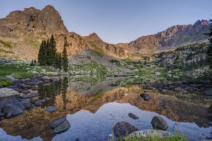
The views from Crater Lake and Mirror Lake in the Indian Peaks Wilderness are some of the most iconic views in the Colorado mountains. I was excited to finally get a chance to see them on a recent backpacking trip with my sons. The area didn’t disappoint. Several fine waterfalls can be viewed along the Cascade Creek trail en route to the lakes. Both lakes are beautiful in their own right but the view from Mirror Lake with Lone Eagle Peak soaring behind it makes for a stunning photograph.
The trail begins at the Monarch Lake trailhead at the back end of Granby Reservoir. It follows the north shoreline of Monarch Lake before entering the wilderness around mile 1.2. The trail reaches its first branch at mile 1.6 as the Arapaho Pass trail connects off to the right. Stay on the main trail and pass over Buchanan creek a bridge just over the 2 mile mark. The trail then begins to climb up switchbacks for a half mile or so before flattening out on its way to the junction with the Buchanan Pass trail. Bear right onto the Cascade Creek trail and cross over a bridge near the confluence of the two creeks. The trail climbs steeply to the first of many cascades. This one is notable for the narrow, rocky canyon it pours out from.
The trail climbs again and you come to another bridge at 4.4 miles. Shortly thereafter, you come to the first of four cascades which comprise Cascade Falls. The trail becomes steep and rocky at this point as it winds its way past each of the four falls. The last one is located in an open valley at mile 5.2. The trail now opens into a large meadow filled with wildflowers in July. Several columbine paintbrush, and larkspur dot the hillside. This is a great spot for a rest as the trail begins a steep climb toward the junction with the Pawnee Pass trail. You reach the junction at mile 6.4. Pawnee Pass is to the left. Bear right and head toward the lake basin. The trail becomes very rocky here and quickly enters what looks like an abandoned stream bed. Climb up the narrow canyon and you come out atop a large rock slab. The area is marked with cairns.
After a short jaunt through open forest, the trail again crosses Cascade Creek over a relatively new bridge at mile 7.4. You’re almost to Mirror Lake but you need to scale some switchbacks first. Finally, the epic view from the shore of Mirror Lake awaits around mile 7.8. Lone Eagle Peak’s pointed spire towers straight in front of you. If you’re spending the night, find an open campsite if you have the necessary reservation. There are 12 campsites in all between Mirror Lake and Crater Lake. Follow the trail to the left around the west side of the lake. It becomes very hard to follow in spots but just keep heading in this direction. Once you pass the far shore of the lake, you will come to a reflecting tarn with an amazing view of Lone Eagle Peak. Follow the trail around to the right and up over a large rock outcropping. Finally, you’ve reached the end of the trail at Crater Lake.
I found sunset to be the the best time to shoot Mirror Lake but an hour after sunrise is also good. Crater Lake is best at sunrise.
Cascade Creek, Indian Peaks Wilderness, CO
Mirror Lake, Indian Peaks Wilderness, CO
Mirror Lake and Lone Eagle Peak, Indian Peaks Wilderness, CO
Mirror Lake, Indian Peaks Wilderness, CO
Reflecting Tarn, sunset, near Crater Lake, Indian Peaks Wilderness, CO
Crater Lake, Indian Peaks Wilderness, CO
Reflecting tarn, Lone Eagle Peak, Indian Peaks Wilderness, CO