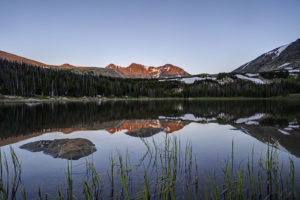
Lost Lake Rocky Mountain National Park
The Lost Lake trail in the northeast corner of Rocky Mountain National Park provides access to a number of lakes and some good fishing. The reward after a long trek…
The Lost Lake trail in the northeast corner of Rocky Mountain National Park provides access to a number of lakes and some good fishing. The reward after a long trek…
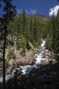
Booth Falls is a strenuous hike to a 60 foot waterfall in the Gore Range in the Eagles Nest Wilderness near Vail, CO. The falls plunge down a steep crack…
Boulder sets its all-time record for snowfall in a winter with this past storm. The spring snow storm dumped 15 inches on the city bringing the annual total to 151…
I finally decided to do some snowshoeing this winter. I went up to the Brainard Lake Recreation area in the Indian Peaks Wilderness. First, I stopped at Red Rock Lake…
I spent 4 days in the Colorado high country last week. The aspen were at peak or just beginning to turn in some places. Grand Mesa and Boreas Pass were…
I backpacked the short 3 mile trip to Herman Lake near Loveland ski area so I could photograph the mountains in the light of the full moon. The area has…
I backpacked the Gilpin Lake/Gold Creek Lake loop in the Mt. Zirkel Wilderness otherwise known as the Zirkel Circle over the 4th of July. The trail is strenuous at times…
After a recent light snowfall, I woke up to a wonderland of a thick layer of frost coating virtually everything in sight. I grabbed my camera and headed out to…
Black Lake in Rocky Mountain National Park is a long but rewarding hike in the Glacier Gorge area of the park. The hike features a couple of beautiful lakes (including…
I have been meaning to hike Picket Wire Canyon near La Junta, CO for some time now, but I kept putting it off. I finally went down there to do…