I spent a few days in the San Juan Mountains of Colorado recently. I love the area because lakes abound as do wildflowers. I started my trip in American Basin near the summit of Cinnamon Pass and ended up hiking the Blue Lakes basin near Ridgway. The wildflowers were abundant this year which made the trip even more rewarding.
American Basin
American Basin is best known for being located at the trailhead for Handies Peak, one of Colorado’s 54 fourteeners. It also boasts some glorious fields of wildflowers in late July. I had lasted visited the area in 2009 and was greeted by an explosion of columbine. While the snowfall was tremendous this past winter, the rain has not come to southern Colorado this year so the columbine were mainly absent. However, fields of larkspur and orange sneezeweed were everywhere. Also, flowers lined the stream draining the basin. The route into the basin is relatively easy until about a half mile from the Handies Peak trailhead. A high clearance vehicle of any sort will get you to this point. It is located 18 miles west of San Cristobal Reservoir near Lake City or 2 miles east of the Cinnamon Pass summit. However, above the dispersed camping area in the basin, the road becomes much rockier and all-terrain tires become helpful. If continuing over Cinnamon Pass to Silverton, I would say the same applies. The road is generally passable with high clearance but there two spots, one just below the summit and one at the junction of the Cinnamon Pass and Engineer Pass roads that more aggressive tires would be most helpful. I survived in my X5 equipped with highway tires, but not easily.

Wildflowers, American Basin, San Juan Mountains, CO

Wildflowers, American Basin, San Juan Mountains, CO

Wildflowers, American Basin, San Juan Mountains, CO

Wildflowers, American Basin, San Juan Mountains, CO

Wildflowers, American Basin, San Juan Mountains, CO

Wildflowers, American Basin, San Juan Mountains, CO

Wildflowers, American Basin, San Juan Mountains, CO

Wildflowers, American Basin, San Juan Mountains, CO

Wildflowers, American Basin, San Juan Mountains, CO
Alta Lake
I next ventured to Alta Lake near Telluride. The lake is located at the end of a rough road off of Highway 145 about 5 miles south of Telluride. I reached the lake and its abundant dispersed camping area after a few miles driving along the rough road. The lake boasts fishing for small rainbow trout and is a popular camping location. It is also a photogenic spot for sunset photography as a large mountain sits just behind the lake to the east. I also explored upper Alta Lake which is a quarter mile or so up a trail. It is not as photogenic and is too shallow to support a good fish population.

Alta Lake, Telluride, CO

Alta Lake, Telluride, CO

Alta Lake, Telluride, CO

Alta Lake, Telluride, CO

Alta Lake, Telluride, CO

Alta Lake, Telluride, CO
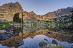
Hope Lake
The next morning I hiked to Hope Lake which is located off another dirt road past Trout Lake. Hope Lake is one of the prettiest lakes in Colorado. Its turquoise blue water stands in stark contrast to the mountains directly behind it. The lake is reachable via a 2.5 mile hike from a trailhead located at a sharp bend in the road. The trailhead is about 2.5 miles from the turn off Trout Lake road onto FR 627. The hike itself is easy for the first mile and a half and then gains most of its 1,130 foot elevation gain in the last mile. The trail begins by ascending a moderate slope for a quarter mile. It then crosses a stream and drops all of that elevation as the trail routes around a huge rock fall. The trail crosses this sharp slate field and then descends to a larger stream crossing around the 1.5 mile mark. The trail then beings its steep ascent up 22 switchbacks. Views of Vermillion Peak open up here. Across the valley, you can see Trout Lake below and Wilson and Sunshine Peak in the distance. The distinctive lizard head can also be seen. As you ascend the last of the switchbacks, fields of wildflowers are all around you. Paintbrush is the dominant flower found here. Finally, you reach the lake after a short quarter mile ascent. Hikers can continue another .7 mile to the pass above Hope Lake.

Hope Lake Trail, Telluride, CO

Hope Lake Trail, Telluride, CO

Hope Lake Trail, Telluride, CO

Hope Lake Trail, Telluride, CO

Hope Lake Trail, Telluride, CO

Hope Lake Trail, Telluride, CO

Hope Lake Trail, Telluride, CO

Hope Lake Trail, Telluride, CO

Hope Lake Trail, Telluride, CO

Hope Lake Trail, Telluride, CO

Hope Lake Trail, Telluride, CO

Hope Lake Trail, Telluride, CO

Hope Lake Trail, Telluride, CO
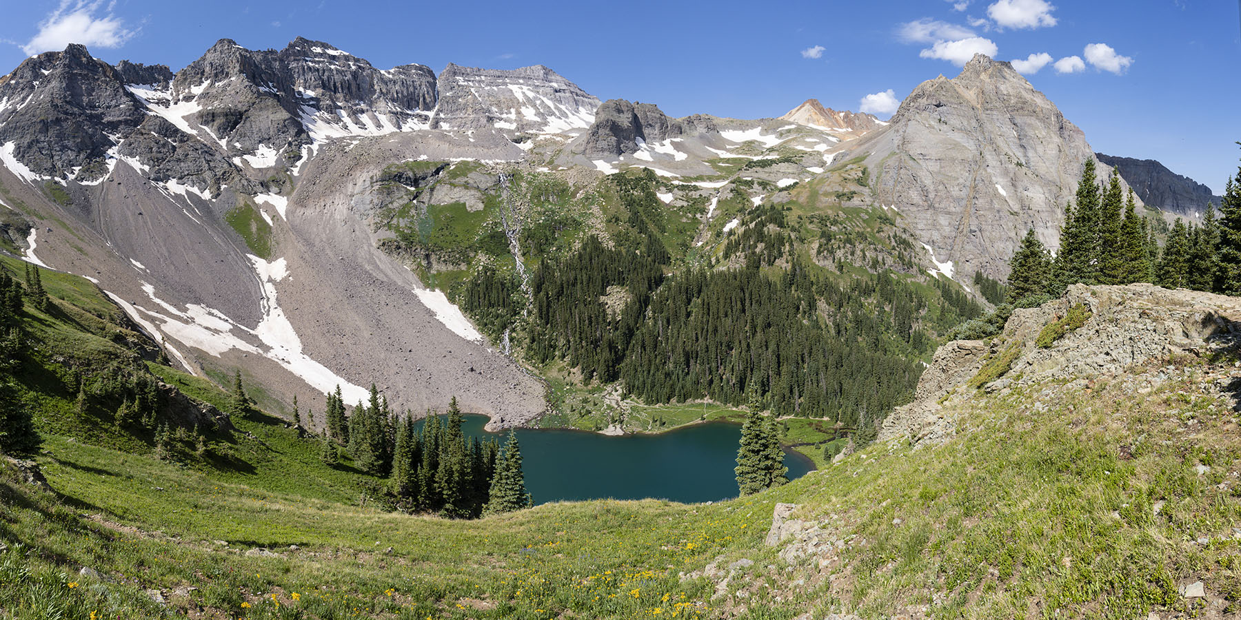
Blue Lakes
Not far from the town of Ridgway is the trail to the Blue Lakes in the Mt Sneffels wilderness. The trail is located at the end of County Road 7, a few miles west on Highway 62 from Ridgway. The 9 mile dirt road is normally passable by passenger car, but this year the road is in terrible condition. It is suitable for high clearance vehicles only, especially the last 1.5 miles. Huge ruts pock mark the last 5 miles of the road. I went 10 mph along this section. Once reaching the trailhead, be prepared for a steep hike. The trail is 3.3 miles to lower Blue Lake, but it feels far longer. The trail begins climbing steeply after about a .25 mile. The trail has many wooden steps through this section. After a mile, it begins to flatten out. The trail undulates here for about a half mile before crossing a large stream. The trail opens up here and features a large field of flowers, mostly cow parsnip. It then ascends steeply once more via a series of switchbacks. You reenter the forest and then come to a waterfall about mile 2.75. A small trail descends to the creek here. You pass another small waterfall before passing through a small grove of trees before coming to the lower lake. The dispersed camping is located here for the numerous backpackers that use the trail as a base to climb Mount Sneffels. Bring your fishing pole as there are large brook trout in this lake (I stupidly left mine in the car). Hikers can continue to the left of the lake and ascend the steep ridge to the middle and upper lakes. Three stream crossings are required. This year, the first requires debooting and crossing the outlet stream. Bring sandals as this area is full of sharp rocks. I found crossing right at the outlet the easiest spot. The trail veers leftward and then crosses another creek in about .2 mile. Some logs are set up here to cross but are useless. Just cross on the slightly submerged rocks. After crossing the creek, veer right. The trail was underwater here so was hard to spot. The trail ascends steeply before recrossing this small creek. With so much snowmelt, this crossing was challenging in boots but doable. The trail now makes a very steep push up the hill. A field of purple larkspur flowers grows in abundance on this hillside. Views of the lower lake and Mt Sneffels begin to open up here. The middle lake quickly comes into view on the left. The trail continues past the lake to the right to the upper lake and then the pass. Caution. I’ve hiked up toward the pass before, and the trail becomes faint through the rock scree and is impossibly steep here. A helmet and trekking poles are a must. For the truly adventurous hiker, you can take the pass over to Yankee Boy Basin near Ouray. If wishing to see Yankee Boy, my recommendation is to drive up from the Ouray side and hike through the fields of wildflowers en route to the pass from that side. See below.


Yankee Boy Basin
One place to see huge fields of wildflowers without doing much hiking is Yankee Boy basin. The basin is located about six miles from Ouray along the Camp Bird road. The raid is easy for the first three miles to the mine, but then steepens and requires 4 wheel drive. A large dip prevents travel for lesser vehicles as you come to a couple of large waterfalls. I parked here and hiked a couple of miles up the road. The views and flowers are impressive. Again, columbine were mainly missing this year but the huge fields of larkspur made up for it. The trailhead for the Sneffels Pass is about 2 miles from the waterfalls. My advice is rent an ATV or Jeep in town if you don’t have one and drive to the trailhead.

Wildflowers, Yankee Boy Basin, Ouray, CO

Wildflowers, Yankee Boy Basin, Ouray, CO

Wildflowers, Yankee Boy Basin, Ouray, CO

Wildflowers, Yankee Boy Basin, Ouray, CO

Wildflowers, Yankee Boy Basin, Ouray, CO

Wildflowers, Yankee Boy Basin, Ouray, CO

Wildflowers, Yankee Boy Basin, Ouray, CO

Wildflowers, Yankee Boy Basin, Ouray, CO