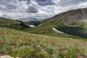
Tag: wildflowers

  • Pitkin Lake

    It had been about 25 years since I had been up to Pitkin Lake in the Eagles Nest Wilderness near Vail so I decided to go back this past week. Pitkin Lake is a beautiful place. The hike features a couple of waterfalls, wildflower-filled meadows, and soaring peaks. What’s not to like? The steepness of the hike, for one. This is a challenging backpack. Although the trail is listed at 4.8 miles, the trek is far longer. It gains 3,000 vertical feet and takes about 4.5 hours and about 3.75 hours going down. My guess is this hike is closer to 5.7 miles each way, almost 2 miles longer roundtrip than advertised.

    The trail starts in East Vail by crossing Pitkin Creek almost immediately. Then the fun begins, It climbs steeply over the next .5 mile, gaining about 500 feet in elevation in the process. The trail mellows out a little but and then gets pretty flat as it wanders through aspen trees. At mile 1.9 (or 2.7 in actual distance), the trail provides an overlook of a large waterfall off to the right. From here, the trail ascends at a steep incline for the next 1.5 miles before it reaches a second waterfall, this time on the left. This stretch of trail left my quads burning and required a couple of breaks. It flattens out thankfully just before coming to a second waterfall at around mile 3.5 (4.3). Access is limited due to rocks and willows. I could not get a decent photo of it. Past the waterfall, the trail ascends steeply to the right of the waterfall and then alternates steep sections with flatter ones. The trail is quite marshy through this section and is quite mosquito-filled. Finally, the trial opens up into a beautiful meadow. The flowers were just beginning to pop in this section.

    Once you get to the lake, all is forgiven, however. It is a serene setting. Colorado cutthroat trout inhabit the lake and my son and I caught a couple. /we saw no none else camped in the basin which was amazing.

    Getting to the trialhead

    Parking is limited at this trail. There are about 20 spots but they are limited to three hours (not enouh time to do even half the trail). The best course is to park near the vail transit center and catch the free East Vail hiker express. The shuttle makes a few stops at the most popular trailheads. The one for this hike is Falls at Vail. The shuttle stop is about a .25 mile downhill from the trailhead. If you are backpacking and need overnight parking, the Redstone parking garage in West Vail is your best bet. It costs $15 for the night (as opposed to $30 in the lot by the transit center). You will need to walk an additional mile to get to this garage or catch the free shuttle from the transit center.

  • San Juan Mountains of Colorado

    San Juan Mountains of Colorado

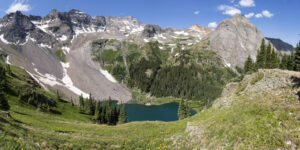
    I spent a few days in the San Juan Mountains of Colorado recently. I love the area because lakes abound as do wildflowers. I started my trip in American Basin near the summit of Cinnamon Pass and ended up hiking the Blue Lakes basin near Ridgway. The wildflowers were abundant this year which made the trip even more rewarding.

    American Basin

    American Basin is best known for being located at the trailhead for Handies Peak, one of Colorado’s 54 fourteeners. It also boasts some glorious fields of wildflowers in late July. I had lasted visited the area in 2009 and was greeted by an explosion of columbine. While the snowfall was tremendous this past winter, the rain has not come to southern Colorado this year so the columbine were mainly absent. However, fields of larkspur and orange sneezeweed were everywhere. Also, flowers lined the stream draining the basin. The route into the basin is relatively easy until about a half mile from the Handies Peak trailhead. A high clearance vehicle of any sort will get you to this point. It is located 18 miles west of San Cristobal Reservoir near Lake City or 2 miles east of the Cinnamon Pass summit. However, above the dispersed camping area in the basin, the road becomes much rockier and all-terrain tires become helpful. If continuing over Cinnamon Pass to Silverton, I would say the same applies. The road is generally passable with high clearance but there two spots, one just below the summit and one at the junction of the Cinnamon Pass and Engineer Pass roads that more aggressive tires would be most helpful. I survived in my X5 equipped with highway tires, but not easily.

    Alta Lake

    I next ventured to Alta Lake near Telluride. The lake is located at the end of a rough road off of Highway 145 about 5 miles south of Telluride. I reached the lake and its abundant dispersed camping area after a few miles driving along the rough road. The lake boasts fishing for small rainbow trout and is a popular camping location. It is also a photogenic spot for sunset photography as a large mountain sits just behind the lake to the east. I also explored upper Alta Lake which is a quarter mile or so up a trail. It is not as photogenic and is too shallow to support a good fish population.

    Hope Lake

    The next morning I hiked to Hope Lake which is located off another dirt road past Trout Lake. Hope Lake is one of the prettiest lakes in Colorado. Its turquoise blue water stands in stark contrast to the mountains directly behind it. The lake is reachable via a 2.5 mile hike from a trailhead located at a sharp bend in the road. The trailhead is about 2.5 miles from the turn off Trout Lake road onto FR 627. The hike itself is easy for the first mile and a half and then gains most of its 1,130 foot elevation gain in the last mile. The trail begins by ascending a moderate slope for a quarter mile. It then crosses a stream and drops all of that elevation as the trail routes around a huge rock fall. The trail crosses this sharp slate field and then descends to a larger stream crossing around the 1.5 mile mark. The trail then beings its steep ascent up 22 switchbacks. Views of Vermillion Peak open up here. Across the valley, you can see Trout Lake below and Wilson and Sunshine Peak in the distance. The distinctive lizard head can also be seen. As you ascend the last of the switchbacks, fields of wildflowers are all around you. Paintbrush is the dominant flower found here. Finally, you reach the lake after a short quarter mile ascent. Hikers can continue another .7 mile to the pass above Hope Lake.

    Blue Lakes

    Not far from the town of Ridgway is the trail to the Blue Lakes in the Mt Sneffels wilderness. The trail is located at the end of County Road 7, a few miles west on Highway 62 from Ridgway. The 9 mile dirt road is normally passable by passenger car, but this year the road is in terrible condition. It is suitable for high clearance vehicles only, especially the last 1.5 miles. Huge ruts pock mark the last 5 miles of the road. I went 10 mph along this section. Once reaching the trailhead, be prepared for a steep hike. The trail is 3.3 miles to lower Blue Lake, but it feels far longer. The trail begins climbing steeply after about a .25 mile. The trail has many wooden steps through this section. After a mile, it begins to flatten out. The trail undulates here for about a half mile before crossing a large stream. The trail opens up here and features a large field of flowers, mostly cow parsnip. It then ascends steeply once more via a series of switchbacks. You reenter the forest and then come to a waterfall about mile 2.75. A small trail descends to the creek here. You pass another small waterfall before passing through a small grove of trees before coming to the lower lake. The dispersed camping is located here for the numerous backpackers that use the trail as a base to climb Mount Sneffels. Bring your fishing pole as there are large brook trout in this lake (I stupidly left mine in the car). Hikers can continue to the left of the lake and ascend the steep ridge to the middle and upper lakes. Three stream crossings are required. This year, the first requires debooting and crossing the outlet stream. Bring sandals as this area is full of sharp rocks. I found crossing right at the outlet the easiest spot. The trail veers leftward and then crosses another creek in about .2 mile. Some logs are set up here to cross but are useless. Just cross on the slightly submerged rocks. After crossing the creek, veer right. The trail was underwater here so was hard to spot. The trail ascends steeply before recrossing this small creek. With so much snowmelt, this crossing was challenging in boots but doable. The trail now makes a very steep push up the hill. A field of purple larkspur flowers grows in abundance on this hillside. Views of the lower lake and Mt Sneffels begin to open up here. The middle lake quickly comes into view on the left. The trail continues past the lake to the right to the upper lake and then the pass. Caution. I’ve hiked up toward the pass before, and the trail becomes faint through the rock scree and is impossibly steep here. A helmet and trekking poles are a must. For the truly adventurous hiker, you can take the pass over to Yankee Boy Basin near Ouray. If wishing to see Yankee Boy, my recommendation is to drive up from the Ouray side and hike through the fields of wildflowers en route to the pass from that side. See below.

    Yankee Boy Basin

    One place to see huge fields of wildflowers without doing much hiking is Yankee Boy basin. The basin is located about six miles from Ouray along the Camp Bird road. The raid is easy for the first three miles to the mine, but then steepens and requires 4 wheel drive. A large dip prevents travel for lesser vehicles as you come to a couple of large waterfalls. I parked here and hiked a couple of miles up the road. The views and flowers are impressive. Again, columbine were mainly missing this year but the huge fields of larkspur made up for it. The trailhead for the Sneffels Pass is about 2 miles from the waterfalls. My advice is rent an ATV or Jeep in town if you don’t have one and drive to the trailhead.

  • Crested Butte Wildflowers 2023

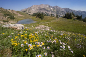
    I took a quick trip to Crested Butte to check out the wildflowers this year. The flowers weren’t as ever-present as they have been in the past but in areas that had them they were in abundance. Some of the fields of lupine and Mules Ears were resplendent. I was even treated to a sunset lighting up Marcelina Mountain at the end of the evening. The areas with the most flowers seemed to be one hillside at the start of the Brush Creek Road and then the very start of the Gothic Road leading into the East River Valley just north of town. I did not see as many flowers around the Slate River Road as I had see in the past. But all in all, this appears to be a good year for flowers in Colorado. I can’t wait to check out the high alpine flowers over the next couple of weeks.

  • Moab Wildflowers 2023

    Moab Wildflowers 2023

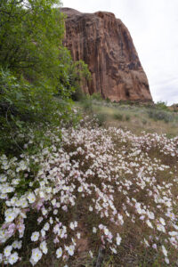
    The winter rains in the west brought some pretty wildflowers this spring to the Moab, UT area. I visited Arches and Canyonlands along with Grandstaff Canyon on this trip. Mountain Pepper plant was by far the most prolific flower in Arches while evening primrose was exploding near Green River.

    Arches had an incredible bloom of mountain pepper plant near Balanced Rock, It seemed every bush was in full bloom. Meanwhile, Canyonlands had nice displays of lupine and desert paintbrush. Grandstaff Canyon is a verdant canyon located just 4 miles east of Moab along Highway 128. The canyon used to be named Negor Bill Canyon for those of you who remember that name. Huge patches of globe mallow and primrose were blooming in the canyon.

  • California Wildflowers 2023

    California Wildflowers 2023

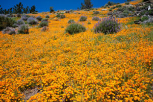
    I did a quick trip out to California to check out the remnants of the 2023 wildflower season. I was not disappointed. Both Carrizo Plain National Monument and Mt. Figueroa has tremendous displays of flowers. The poppies were as thick as I have ever seen them at Mt. Figueroa. All that rain earlier this season really proceeded a stunning display of flowers.

    The Carrizo Plain is located near Bakersfield, CA on one end and about 1.5 hrs from San Luis Obispo on the other. I drove the 45 mile dirt road from end to end. The best displays were air the northern part from Soda Lake northward. The tidy tips and hillside daisy were blooming in profusion at the southern end of Soda Lake. Large fields of owl’s clover could also be seen nearby.

    At Mt. Figueroa near Los Olives, the poppies were the star. I have never seen such thick carpets of poppies there. Grass mountain had a good display going near the top but the best spot was right at the entrance station. The fields there were radiant orange. Lupine and bush lupine were also mixed in giving the area an orange and purple glow. What an amazing sight to see.

  • Arizona Wildlfowers 2023

    Arizona Wildlfowers 2023

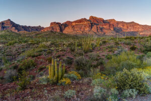
    I flew to Arizona to check out the wildflowers for a short trip this week. I saw a few great shows of wildflowers but it took some driving to find them. Some areas are experiencing a superbloom of flowers while others, especially near Tucson, are barely green. The best areas I found were the Superstition Mountains near Apache Junction just east of Phoenix, Organ Pipe National Monument near Ajo, and Highway 77 south of Globe.

    I began my trip by driving down to Organ Pipe. I had come too early to see the great show in 2019 but this year was also worth the trip. Brittlebrush is blooming like crazy in some spots of the park and a field of lupine was blooming in profusion near the park entrance. There was not the variety of wildflowers seen in other years like 2005 but it was still pretty to see. Brittlebrush is booming along the mountain loops. The Coulter’s lupine in particular were right at their peak bloom. I took a hike on the Arch trail and found a few poppies blooming as well.

    Lost Dutchman State Park between Phoenix and Superior was lush green this year. It made for quite the sight. Unfortunately, the weather was rainy the morning I was there so not much time to explore. The rain stopped by the time I got to the Peralta Trailhead on the backside of the park and it was full of brittle brush, I also found a ton of lupine atop one of the nearby hillsides. I then traveled to Globe and headed a little ways down Highway 77. Some nice fields of poppies were blooming on the hillsides.

  • Silver Dollar Lake Wildflowers

    Silver Dollar Lake Wildflowers

    It is wildflower time in Colorado. The peak is just about past but there is still time to get out and enjoy the flowers. I did a short hike to Silver Dollar Lake and Murray Lake near the summit of Guanella Pass. The paintbrush were going crazy in the meadow between the two lakes. The hike itself is relatively short but is steep in sections. It is about 5 mile roundtrip. Most of it is above treeline as well. The views are amazing but oxygen is in short supply. The trail meanders through the forest for about 1.2 mile before veering left. It then switchbacks steeply above the private lake to your right. The flowers start in earnest along drainage areas about halfway up the trail. Enjoy!

    To get to the Silver Dollar Lake trail, take the Guanella Pass road out of Georgetown, Colorado. Head south until reaching the campground near the summit. The turn for the trailhead is just past the campground and just before a steep switchback in the road. A parking area is on the right. Vehicles with a little clearance can easily make the higher parking lot about .75 mile up the road. Park before you reach the Naylor Lake lodge.

  • Grand Teton and Yellowstone

    Grand Teton and Yellowstone

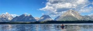
    After backpacking to Alaska Basin, my wife and I spent a couple of days in Grand Teton National Park and Yellowstone National Park. With not a lot of time to spend, we hit some of the highlights of each park. We kayaked in Jackson Lake, took in the sunrise at Oxbow Bend, and then headed to Yellowstone. We caught the eruption of Old Faithful and toured around the Grand Prismatic Pool area. I really liked Firehole Falls at the beginning of the Firehole River canyon. The best was yet to come, however. I found a huge field of wildflowers near the shore of Yellowstone Lake and then we caught the sunset at Gull Point along the lake. What color! In the morning, we made our way out of the park to pick up our son at Buffalo Bill Boy Scout camp. There were more fields of flowers just before Sylvan Lake. The yellow was quite a contrast with the stark tree poles killed by forest fires in the area. Unfortunately, there was not much wildlife to be spotted. Only the occasional bison and elk. I think the heat had many animals hiding up high.

  • Eccles Pass

    Eccles Pass

    Eccles Pass offers some panoramic views of the Eagles Nest Wilderness near Frisco, CO. I hiked up yesterday to catch the last of the wildflower show for 2020. Despite the haze from 4 wildfires burning in Colorado, it was a beautiful day and the wildflowers did not disappoint.

    To reach the summit of Eccles Pass requires just over a 5 mile hike. The Meadow Creek trail just outside of Frisco provides the primary access to the pass. The trail climbs through stands of aspen for the first mile as it works it way into the wilderness. The trail junction for the short trail to Lily Pad lake appears just after the .5 mile mark. Continue straight and follow the main trail as it quickly ascends through lodgepole pine. Around the 2 mile mark, the trail crosses Meadow Creek over a small bridge and then begins an arduous ascent along a rocky trail for the next 1.25 mile. The trail levels off at this point, and the forest transitions to spruce and fir. Around the 3.5 mile mark, the trail crosses the creek over some logs and limited views through the forest appear. At just over 4 miles, you reach a small beaver pond with dead pines along its shore. A good reflection of the mountains that ring the basin can be seen here. Continue on for about .5 mile and the views begin to open up around you. Shortly, you will come to a trail junction with the Gore Range trail. The faint trail to the left proceeds down to 10 Mile Creek. Go right to ascend the pass.

    This area used to contain a couple of large reflecting pools, but they are now unfortunately filled with grass. The last time I was up here, I photographed some beautiful reflections in the pools. Too bad they’re now history. The surrounding meadows are filled with wildflowers so there’s still beauty to take in, thankfully.

    After the steep climb to the summit of Eccles Pass, the trail drops into the valley below. There are a few small tarns and ponds as well as plenty of wildflowers to attract your eye. At this point, hikers have two options. Return the way you came or camp out in this lovely basin. Shuttle hikers can keep going over Red Buffalo Pass and will come out in East Vail. A side trip to the lovely Gore Lake is highly recommended for those doing this route.

  • Picket Wire Canyon

    I have been meaning to hike Picket Wire Canyon near La Junta, CO for some time now, but I kept putting it off.  I finally went down there to do a hike to the dinosaur tracks.  The wait was worth it.  The hike is a long one but the canyon is very green compared to the surrounding landscape. The wildflowers were also blooming in abundance due to some recent spring rains.  

    The Hike

    The trail starts at the Withers trailhead about 45 minutes south of La Junta.  The trail quickly descends into the canyon from the parking lot and loses about 250 feet in elevation.  Once in the main canyon, wildflowers dot the landscape including prickly primrose, sunflowers, and cholla cactus.  An old ranch house is reached after a mile.  The next landmark is a cemetery located 3.7 miles from the trailhead.  In this stretch of trail, views open up of the canyon and the Purgatory River below.  The dinosaur tracks are found another 1.5 miles down the trail.  Several Brontosaurus tracks tracks can be seen here.  An even bigger collection can be found just across the river, but due to high water, I decided not to wade it.  The hike is 11.6 miles round trip.  There is very little shade so bring plenty of water.  

    Directions

    Picket Wire Canyon is located south of LaJunta.  Take highway 109 from La Junta and turn onto the signed dirt road top the right after 13 miles.  The road will turn at mile 8 toward the canyon.  Follow this road for 6 miles.  One final turn is required and this road goes 3 miles to the trailhead.  The way is well-signed.  

Plugin from the creators ofBrindes Personalizados :: More at PlulzWordpress Plugins