Tag: mountains

  • Pitkin Lake

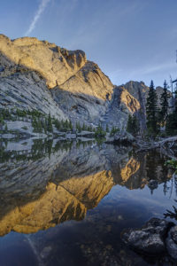
    It had been about 25 years since I had been up to Pitkin Lake in the Eagles Nest Wilderness near Vail so I decided to go back this past week. Pitkin Lake is a beautiful place. The hike features a couple of waterfalls, wildflower-filled meadows, and soaring peaks. What’s not to like? The steepness of the hike, for one. This is a challenging backpack. Although the trail is listed at 4.8 miles, the trek is far longer. It gains 3,000 vertical feet and takes about 4.5 hours and about 3.75 hours going down. My guess is this hike is closer to 5.7 miles each way, almost 2 miles longer roundtrip than advertised.

    The trail starts in East Vail by crossing Pitkin Creek almost immediately. Then the fun begins, It climbs steeply over the next .5 mile, gaining about 500 feet in elevation in the process. The trail mellows out a little but and then gets pretty flat as it wanders through aspen trees. At mile 1.9 (or 2.7 in actual distance), the trail provides an overlook of a large waterfall off to the right. From here, the trail ascends at a steep incline for the next 1.5 miles before it reaches a second waterfall, this time on the left. This stretch of trail left my quads burning and required a couple of breaks. It flattens out thankfully just before coming to a second waterfall at around mile 3.5 (4.3). Access is limited due to rocks and willows. I could not get a decent photo of it. Past the waterfall, the trail ascends steeply to the right of the waterfall and then alternates steep sections with flatter ones. The trail is quite marshy through this section and is quite mosquito-filled. Finally, the trial opens up into a beautiful meadow. The flowers were just beginning to pop in this section.

    Once you get to the lake, all is forgiven, however. It is a serene setting. Colorado cutthroat trout inhabit the lake and my son and I caught a couple. /we saw no none else camped in the basin which was amazing.

    Getting to the trialhead

    Parking is limited at this trail. There are about 20 spots but they are limited to three hours (not enouh time to do even half the trail). The best course is to park near the vail transit center and catch the free East Vail hiker express. The shuttle makes a few stops at the most popular trailheads. The one for this hike is Falls at Vail. The shuttle stop is about a .25 mile downhill from the trailhead. If you are backpacking and need overnight parking, the Redstone parking garage in West Vail is your best bet. It costs $15 for the night (as opposed to $30 in the lot by the transit center). You will need to walk an additional mile to get to this garage or catch the free shuttle from the transit center.

  • Dream Lake Loop

    I hiked a loop from Bear Lake parking lot in Rocky Mountain National Park yesterday. I photographed the sunrise at Dream Lake and then ventured over the hill to Lake Hiyaha about 1 mile away. Although virtually at the same elevation, the two lakes are separated by a large hill that must be scaled. So the trail ascends and descends steeply form Dream Lake. Lake Hiyaha has a weird green mile color right now due to glacial sediment being disturbed. The lake itself is not very photogenic due to the presence of large boulders all along its shoreline. The tarn just in front of the lake was more photogenic in my mind. I then hiked the connector trail with the glacial gorge trail. About half a mile from the junction, there are two small tarns that are quite photogenic. I did get wet getting to the shore of one, however. It is quite the bog!

  • Willow Lake-Sangre de Cristo

    Willow Lake-Sangre de Cristo

    My boys and I backpacked to Willow Lake in the Sangre de Cristo mountain range near Crestone, CO last weekend. It is a challenging hike, but the beautiful lake at the end of the hike makes it a rewarding one. It is surrounded by mountains in a narrow bowl including Kit Carson and Challenger peaks, two fourteeners. The trail climbs 2900 feet in 5 miles and is not for the faint of heart.

    The hike begins by climbing steadily up switchbacks through aspen and coniferous forest. After a mile, the switchbacks steepen as the trail climbs to a meadow (this is the second hardest portion of the hike). Views of Kit Carson peak open up here. Catch your breath as the next half mile is the only easy section of trail. The trail descends near the meadow and then begins a steady climb upward. More switchbacks await as you climb through the forest. Around the 2.5 mile mark, you will pass a large campsite on the left. The trail continues up switchbacks until leveling off briefly at a stream crossing at mile 3.5. Rest here and take in the pretty waterfall because the next half mile is the steepest of the trail. The trail climbs up through rock scree as it scales a sheer rock face. This section was as steep as any mountain pass I’ve climbed.

    The demoralizing aspect of the trail hits you in the last section. You’d think you’d be done after the last ascent, but there is still another mile to go with yes more switchbacks. You finally arrive at a meadow below Willow Lake where camping is allowed. No camping is allowed at the lake itself. The meadow will be crowded as climbers hiking Kit Carson and Challenger use it as a base camp.

    Finally, if you want to visit Willow Lake climb past the meadow on a steep, rocky path. A social trail through downed timber skirts some of the shoreline. Great views await at the lake with a waterfall draining into the back of the lake as an added bonus. The reflections in the lake were amazing near sunset. The only drawback is that very little of the surrounding mountains are lit with sunlight as the bowl faces diagonally and not much direct sunlight hits the basin. Also, don’t expect to find many fish in the lake. I saw only one brook trout.

    Getting There

    To reach the trailhead for Willow Lake (or South Crestone Lake), take Highway 17 to Moffat (between ALamosa and Salida) and turn east onto County Road T. Follow the road to the town of Crestone and then follow the signs for the Willow trailhead. A rough two mile dirt road takes you to the trailhead. A small parking lot holds about 30 cars, so be prepared to park down the road during busy days.

  • Gap Lakes

    I backpacked to the Gap Lakes in the Snowy Range of Wyoming just before the eclipse.  This is a pretty area with several small lakes and tarns just a short distance form the trailhead.  I camped near South Gap Lake and explored some tarns around the area.  There are many small ponds with beautiful reflections to photograph in this area.  Lewis Lake at the trailhead is perhaps the prettiest of all the lakes.  I will have to return to this area to do some fishing.  

    Getting There

    The trailhead to the Gap Lakes is located at the Libby Lake and Lewis Lake picnic ground which is about a half a mile from the summit of the Snowy Range road. Proceed west out of Laramie, Wyoming for about 30 miles on the Snowy Range Road to reach this area.  The trail itself climbs about two hundred feet in elevation from Lewis Lake and arrives at the Gap Lakes in less than a mile.  You can explore the trial further to reach Deep Lake and other lakes in the region or take a different trail to reach Mirror Lake to the West.  

Plugin from the creators ofBrindes Personalizados :: More at PlulzWordpress Plugins