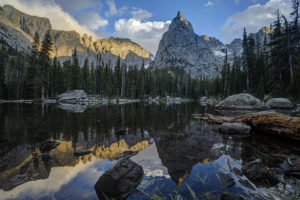
Tag: nature photography

  • Pitkin Lake

    It had been about 25 years since I had been up to Pitkin Lake in the Eagles Nest Wilderness near Vail so I decided to go back this past week. Pitkin Lake is a beautiful place. The hike features a couple of waterfalls, wildflower-filled meadows, and soaring peaks. What’s not to like? The steepness of the hike, for one. This is a challenging backpack. Although the trail is listed at 4.8 miles, the trek is far longer. It gains 3,000 vertical feet and takes about 4.5 hours and about 3.75 hours going down. My guess is this hike is closer to 5.7 miles each way, almost 2 miles longer roundtrip than advertised.

    The trail starts in East Vail by crossing Pitkin Creek almost immediately. Then the fun begins, It climbs steeply over the next .5 mile, gaining about 500 feet in elevation in the process. The trail mellows out a little but and then gets pretty flat as it wanders through aspen trees. At mile 1.9 (or 2.7 in actual distance), the trail provides an overlook of a large waterfall off to the right. From here, the trail ascends at a steep incline for the next 1.5 miles before it reaches a second waterfall, this time on the left. This stretch of trail left my quads burning and required a couple of breaks. It flattens out thankfully just before coming to a second waterfall at around mile 3.5 (4.3). Access is limited due to rocks and willows. I could not get a decent photo of it. Past the waterfall, the trail ascends steeply to the right of the waterfall and then alternates steep sections with flatter ones. The trail is quite marshy through this section and is quite mosquito-filled. Finally, the trial opens up into a beautiful meadow. The flowers were just beginning to pop in this section.

    Once you get to the lake, all is forgiven, however. It is a serene setting. Colorado cutthroat trout inhabit the lake and my son and I caught a couple. /we saw no none else camped in the basin which was amazing.

    Getting to the trialhead

    Parking is limited at this trail. There are about 20 spots but they are limited to three hours (not enouh time to do even half the trail). The best course is to park near the vail transit center and catch the free East Vail hiker express. The shuttle makes a few stops at the most popular trailheads. The one for this hike is Falls at Vail. The shuttle stop is about a .25 mile downhill from the trailhead. If you are backpacking and need overnight parking, the Redstone parking garage in West Vail is your best bet. It costs $15 for the night (as opposed to $30 in the lot by the transit center). You will need to walk an additional mile to get to this garage or catch the free shuttle from the transit center.

  • Havasu Falls

    Havasu Falls

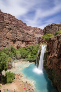
    I finally got a chance to hike to a place I’ve been meaning to get to for the past twenty years-Havasu Falls in Arizona. In recent years, the falls has become an incredibly popular destination, and as a result, requires winning a permit through an on-line lottery application. The Havasupai Indian tribe that runs the lottery has also raised the price of the stay significantly in the past decade to $455 for the three-night stay (by comparison, the same three-night trip would have cost $94 in 2014). But the hassle and cost is worth it. Havasu Falls is one of the most incredible waterfalls I’ve seen, looking completely out of place in the desert canyon it’s located in.

    The trek is epic requiring a 10 mile hike in near the Grand Canyon. The Hulapai Hilltop trail starts atop a large canyon rim. You lose 2400 feet in elevation, much of it over the first mile (yes, your calves are going to feel it). The next part of the hike meanders along a wash through a deep canyon. The canyon is very pretty in parts as the sandstone walls are adorned in desert varnish. At about mile 6, the trail flattens out as the canyon opens up. Shortly, you will cross a bridge over the creek. The environment becomes more riparian and there are many cottonwoods along this stretch. Soon, the village of Supai comes into view. This is part of the Indian reservation so there are strict rules against photography in this part of the hike. The village contains a couple of places to stop for fry bread. I recommend the sweet variety coated in powdered sugar and honey (mine also came with fresh strawberries). Once through the village the trail continues to descend toward Havasu Falls. About a mile from the campground, you will come to Navajo Falls. The creek is very wide here making for a quite pretty waterfall. After rounding a curve (fenced off due to erosion), the trail finally makes it way to the top of Havasu Falls. The noise is thunderous as the creek plummets 70 feet below. Given the presence of calcium limestone, the pool is an iridescent turquoise color. You feel like you’ve been transported to the Caribbean.

    After a dip in the falls, it’s time to find a camp site. There are a number of them scattered throughout the mile-long course of the campground. There are many several sites along the creek itself as well as a number back in the cottonwoods. Amazingly, each site has its own picnic table. The campground ends at Mooney Falls another beautiful waterfall. The descent to Mooney is not for the faint of heart, however. You have to take two sets of rocks stairs through the limestone cliff and then climb backwards down rock stairs cut into the sheer face of the cliff. It’s about 100 foot drop over the edge. Most people are able to do this part of the trail but given my fear of heights, I passed. The trail continues about 2 more miles to a set of large limestone pour overs known as Beaver Falls that apparently make great swimming holes.

    The highlight of the trek of course is Havasu Falls. There are a number of deep pools below the falls that make for great swimming. In the afternoon, this area gets quite crowded. There are a lot of people that have made the trek with you. This is probably due to the fact that hikers can reserve pack horses (for $400) to carry their gear. While this opens the trail to a greater number of people, it does make it seem a little less natural and unspoiled at times. Thankfully, the large campground seems to support the large number of people. I never felt like things were overcrowded.

    After dinner, stargazing is the thing to do here. Be aware, it is too hot in summer to put the rain fly on. The views of the stars was amazing. You are 90 miles from Seligman and 135 miles from Kingman. There is no hint of light pollution here. Given the new moon, the view of the Milky Way way incredible once the clouds cleared.

    While the weather is nice in June, I have to say the heat was intense. It was 104 in the campground and 113 in Las Vegas the day after my trip. But curling up near Havasu Falls to read a book is a great way to pass the afternoon. Due to the heat, I woke up at 4 am to hike out. The 10 mile return hike is almost all up hill and took me 6.5 hours to complete. It was 94 degrees at the Hilltop summit parking lot when I returned to the car at 11 am. Uggh. Bring lots of water for this adventure. You will need it.

    To reach the trailhead, you have to drive 135 miles from Kingman Arizona or 90 miles from Seligman. The closest motel is the Grand Canyon Caverns Inn where you must check in. It is about 5 miles east of the turn for Indian Route 18 located on Route 66. You can also stay in Selgiman about another 25 miles east. The reward here is Lilo’s Diner, a quality restaurant. Flights from either Las Vegas or Phoenix are the closest major airports located 3.5 to 4 hours away.

  • Flattops Fall Color

    The Flattops wilderness in western Colorado is one of the best places to see fall color in Colorado. There are large aspen forests seemingly all through the wilderness. I recently drove from New Castle to Buford and then across the Flattops on County Road 8 to Yampa. I also drove a long section of the Deep Lake ROad near Dotsero. Despite dire predictions of a poor fall in the northern half of the state due to lack of moisture, the colors are some of the best I’ve seen in recent memory. Ripple Creek and Dunkley Passes were both particularly vibrant. I even saw a beautiful sunset atop Ripple Creek Pass. The trees have turned about 50% and many are still green so hopefully the show will last another 7-10 days.

    A word of caution should be issued. Wear bright colors if you go. Fall is hunting season and the Flattops is full of hunters this time of year.

    Getting there:

    There are several roads into the Flattops. County Road 8 runs between Yampa and Meeker for about 75 miles. A detour to Trappers Lake can be made about 30 miles from the Meeker end. Roads also run to Deep Lake (5 miles north of Dotsero) and YamColo Reservoir (also from the Yampa end).

  • Eccles Pass

    Eccles Pass

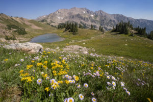
    Eccles Pass offers some panoramic views of the Eagles Nest Wilderness near Frisco, CO. I hiked up yesterday to catch the last of the wildflower show for 2020. Despite the haze from 4 wildfires burning in Colorado, it was a beautiful day and the wildflowers did not disappoint.

    To reach the summit of Eccles Pass requires just over a 5 mile hike. The Meadow Creek trail just outside of Frisco provides the primary access to the pass. The trail climbs through stands of aspen for the first mile as it works it way into the wilderness. The trail junction for the short trail to Lily Pad lake appears just after the .5 mile mark. Continue straight and follow the main trail as it quickly ascends through lodgepole pine. Around the 2 mile mark, the trail crosses Meadow Creek over a small bridge and then begins an arduous ascent along a rocky trail for the next 1.25 mile. The trail levels off at this point, and the forest transitions to spruce and fir. Around the 3.5 mile mark, the trail crosses the creek over some logs and limited views through the forest appear. At just over 4 miles, you reach a small beaver pond with dead pines along its shore. A good reflection of the mountains that ring the basin can be seen here. Continue on for about .5 mile and the views begin to open up around you. Shortly, you will come to a trail junction with the Gore Range trail. The faint trail to the left proceeds down to 10 Mile Creek. Go right to ascend the pass.

    This area used to contain a couple of large reflecting pools, but they are now unfortunately filled with grass. The last time I was up here, I photographed some beautiful reflections in the pools. Too bad they’re now history. The surrounding meadows are filled with wildflowers so there’s still beauty to take in, thankfully.

    After the steep climb to the summit of Eccles Pass, the trail drops into the valley below. There are a few small tarns and ponds as well as plenty of wildflowers to attract your eye. At this point, hikers have two options. Return the way you came or camp out in this lovely basin. Shuttle hikers can keep going over Red Buffalo Pass and will come out in East Vail. A side trip to the lovely Gore Lake is highly recommended for those doing this route.

  • Gore Lake

    Gore Lake

    Gore Lake is one of the prettiest in the Gore Range near Vail, CO. It also boasts some of the biggest trout you’ll see in an alpine environment. Which of course makes it a destination for any serious hiker, fisherman, or photographer. I happen to be all three so of course I had to visit the lake.

    The hike is 6.5 miles long and is steep in several sections. While arduous in spots, the nice thing about this trail it that it intersperses flat, level sections to allow you to catch your brief periodically. It begins at the Gore Creek trailhead off of the Big Horn Road near East Vail. The trail passes the junction with the Deluge Lake trail in about .25 mile and then climbs steeply up into the aspen forest. The aspen are dense for the first 1.5 miles and then give way to conifer forest. Around the 1.5 mile mark, the trail climbs a steep rocky section before crossing Deluge Creek over a bridge at the 2.5 mile mark. The trail passes through willow and several creeks cross the trail over the next mile. The trail now climbs steadily for the next half mile before flattening out on the approach to the trail junction at mile 5. Bear left to head to Gore Lake or stay straight if ascending the very steep Red Buffalo Pass.

    Bearing left to the lake you will pass a grave marker for two Swedes who died in the early 1900s. The next .75 mile is a lung and quad burner. It seems to head straight up the mountain in stretches. When you reach a small waterfall on your right, there is one last sharp incline before the trail flattens out in a lower meadow below the lake. You wander about .5 mile through a boggy environment as partial views of the mountains begin to open around you. Finally, the trail has one last steep section in store as it climbs the last 300 feet or so to Gore Lake over the last .5 mile. The climb is worth it as views of the peaks around the lake open all around. Look for the 18″-22″ cutthroat trout cruising the shallows of the lake. Then enjoy the fields of wildflowers to the south of the lake. This area boasts many good camping spots as well. Be sure to look for mountain goats in the area. I saw at a dozen watering about while I was there.

  • Crater Lake-Indian Peaks Wilderness

    Crater Lake-Indian Peaks Wilderness

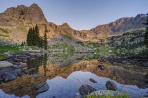
    The views from Crater Lake and Mirror Lake in the Indian Peaks Wilderness are some of the most iconic views in the Colorado mountains. I was excited to finally get a chance to see them on a recent backpacking trip with my sons. The area didn’t disappoint. Several fine waterfalls can be viewed along the Cascade Creek trail en route to the lakes. Both lakes are beautiful in their own right but the view from Mirror Lake with Lone Eagle Peak soaring behind it makes for a stunning photograph.

    The trail begins at the Monarch Lake trailhead at the back end of Granby Reservoir. It follows the north shoreline of Monarch Lake before entering the wilderness around mile 1.2. The trail reaches its first branch at mile 1.6 as the Arapaho Pass trail connects off to the right. Stay on the main trail and pass over Buchanan creek a bridge just over the 2 mile mark. The trail then begins to climb up switchbacks for a half mile or so before flattening out on its way to the junction with the Buchanan Pass trail. Bear right onto the Cascade Creek trail and cross over a bridge near the confluence of the two creeks. The trail climbs steeply to the first of many cascades. This one is notable for the narrow, rocky canyon it pours out from.

    The trail climbs again and you come to another bridge at 4.4 miles. Shortly thereafter, you come to the first of four cascades which comprise Cascade Falls. The trail becomes steep and rocky at this point as it winds its way past each of the four falls. The last one is located in an open valley at mile 5.2. The trail now opens into a large meadow filled with wildflowers in July. Several columbine paintbrush, and larkspur dot the hillside. This is a great spot for a rest as the trail begins a steep climb toward the junction with the Pawnee Pass trail. You reach the junction at mile 6.4. Pawnee Pass is to the left. Bear right and head toward the lake basin. The trail becomes very rocky here and quickly enters what looks like an abandoned stream bed. Climb up the narrow canyon and you come out atop a large rock slab. The area is marked with cairns.

    After a short jaunt through open forest, the trail again crosses Cascade Creek over a relatively new bridge at mile 7.4. You’re almost to Mirror Lake but you need to scale some switchbacks first. Finally, the epic view from the shore of Mirror Lake awaits around mile 7.8. Lone Eagle Peak’s pointed spire towers straight in front of you. If you’re spending the night, find an open campsite if you have the necessary reservation. There are 12 campsites in all between Mirror Lake and Crater Lake. Follow the trail to the left around the west side of the lake. It becomes very hard to follow in spots but just keep heading in this direction. Once you pass the far shore of the lake, you will come to a reflecting tarn with an amazing view of Lone Eagle Peak. Follow the trail around to the right and up over a large rock outcropping. Finally, you’ve reached the end of the trail at Crater Lake.

    I found sunset to be the the best time to shoot Mirror Lake but an hour after sunrise is also good. Crater Lake is best at sunrise.

  • Clear Lake-Wind Rivers

    Clear Lake-Wind Rivers

    Clear Lake in the Big Sandy Lake area of the Wind River range is one of the prettiest alpine lakes I’ve visited. It is set in a large bowl with large prominent mountain peaks surrounding it. Its large size adds to the drama of the setting. Wildflowers dot the meadows surrounding the north side of the lake as well.

    To reach the lake, hike the Big Sandy trail to Big Sandy Lake at the southern end of the wilderness. Then skirt the left side of the lake, pass the junction with the Big Sandy trail to Jackass Pass, and continue around the lake until you reach a crossing of the Big Sandy river. Several logs have been placed across the stream to aid in the crossing. Just before the crossing, you will see the only sign for Clear Lake–it points to Black Joe Lake and Clear Lake to the right. However, once the trail splits after the crossing, no signs tells you which way to go. I made the mistake of going left toward Black Joe lake. You can still reach Clear Lake from here but you needlessly ascend 300 more feet than necessary. So save yourself the trouble and go right at the junction. The trail finishes its circle of Big Sandy Lake and then ascends some gentle switchbacks up to Clear Lake. The lake is about 1 mile past Big Sandy Lake.

    The lake itself is ringed by trees but feels very open. The trail leads around the north side of the lake and continues up to Deep Lake about 1.5 miles up the trail. Clear Lake is a great spot to watch sunrise and sunset, particularly if the winds are calm. The lake can produce some stunning reflections.

  • Cirque of the Towers

    Cirque of the Towers

    My family and I recently backpacked to the Cirque of the Towers in the Wind River range of Wyoming. It is an amazing place where a lake is encircled by high peaks in a glacial basin. The Cirque had been on my radar as a place to visit for many years now so I’m glad I finally had a chance to get there. It was a rough hike but the effort was worth it. As an added bonus, I got to see the comet Neowise peaking out just above the horizon line one evening.

    The hike to the Cirque begins at the Big Sandy trailhead near the southern end of the range. The first section of the hike is a relatively easy jaunt to Big Sandy Lake, five miles from the trailhead. The trail begins by going through the forest before reaching a meadow around the .5 mile mark. From there, the trail begins to ascend up some switchbacks and then levels out around the two mile mark at another large meadow. Here, you begin to see views of the surrounding mountains. The trail again climbs gradually through the trees until arriving at the shores of Big Sandy Lake around mile 5. This is a good place to camp for the night or you can continue up the trail 1.5 to the incomparable Clear Lake.

    The trail skirts the left side of the lake, crosses a small stream, and reaches the junction with the Big Sandy trail to Jackass Pass at mile 5.5. The fun now begins. You gain 1700 feet in elevation in 3 miles but also lose 600 feet of elevation. For the junction, the trail immediately ascends via steep switchbacks to a beautiful meadow. It levels off for the half mile, reaching a small stream and pool. The trail crosses the creek and ascends via steep switchbacks. You climb 300 feet but then descend all 300 feet to the inlet of North Lake. Take a rest here because the trail now ascends up a steep slope through the rocks above Arrowhead Lake. It soon comes to a trail junction with the Arrowhead Lake climbing route. Go right and head up through the boulders above Arrowhead Lake. Here you begin to glimpse the amazing scenery of the area. Peaks soar around you. When you reach the high point, your heart sinks as you can now see the trail drops most of the way down to Arrowhead Lake before reascending to Jackass Pass. The trail splits in three after the descent, as the left branch descends the rest of the way to Arrowhead Lake, the central branch leads to the base of Cirque, and the right branch ascends the pass. Take the right fork and do one more steep climb before you finally reach the summit of the pass.

    At the pass, take in the view. The peaks of the Cirque of the Towers surround you and Lonesome Lake can be seen far below you. Peaks such as the Wolf’s Head, Shark Nose, and Pingora Peak cut a distinct profile. Follow the trail down toward the lake. You can proceed left to a large waterfall and the head of the basin or you can go right and camp past the lake and continue on the trail toward Papoose Lake. I camped in the area above the basin so I could visit the lake and waterfall. The lake contains many small cutthroat trout which are willing biters.

  • Lost Lake Rocky Mountain National Park

    Lost Lake Rocky Mountain National Park

    The Lost Lake trail in the northeast corner of Rocky Mountain National Park provides access to a number of lakes and some good fishing. The reward after a long trek is some fine alpine scenery.

    I hiked the trail to Lost Lake in one long day. It took about 10 hours to make the 9.7 mile climb up to the lake. The trail is benign for most of its journey but 2 steep sections provide for most of the 2800 foot elevation gain. The trail starts at the Dunraven trailhead north of Estes Park and spends the first half meandering through the Comanche Peak Wilderness. At the start, it descends 200 feet to the Big Thompson River and crosses the river at a newly installed bridge (the old one was washed away along with several others in the flood of 2013). The trail parallelss the river for a long flat stretch as it passes through private property. You cross the river again and pass a large horse stable. The trail stays flat for the next mile and a half as it works its way along the river.

    At mile 3.5, the trail begins its steep ascent to the national park boundary. The trail climbs steeply through aspen forest and lodgepole pine. The river quickly disappears in this stretch. The trail mellows out as it reaches the boundary and passes the intersection with the Boundary Trail. The trail now follows the river for the next 1.5 miles on a fairly flat grade. Around Happily Lost Wilderness campground, the trail once again steepens around mile 6.7. You pass a junction with the Stormy Peak Pass trail and continue grinding upwards along the rocky trail. The thundering Lost Falls can be heard through the trees but to actually see it, you’ll have to cut left into the forest through downed timber just past the trail junction. Lost Falls is a pretty, 60-foot cascade, but the view is partially obscured by rocks and trees.

    Back on trail, you pass a few more wilderness campsites. The trail flattens out again after Lost Meadow. The lake is now only a mile away. There are four camp sites near the lake, although none really provide a good view of it. I camped at one of the upper sites.

    The lake is in a pretty basin with Rowe Peak towering in the distance. You can ascend a social trail through the trees to the left of the lake to reach the upper basin where the scenery becomes spectacular. Husted Lake and Louise Lake lie to to the south of Lost Lake in this upper basin. Unobstructed views of Rowe Peak greet the visitor. So does wind. It was unrelenting in the three days I spent in the basin. The more adventurous can even explore the Dunraven Lake basin to the east, but large snow fields blocked entrance during my visit.

    The lakes in the area all support a good cutthroat trout population which proved fun to fish during my stay.

  • Boulder Spring Snow

    Boulder sets its all-time record for snowfall in a winter with this past storm. The spring snow storm dumped 15 inches on the city bringing the annual total to 151 inches. April has been a very snowy month so far. It was a beautiful morning to be outside despite the 5 degree temperatures. I am not a big fan of spring snow, but I know the snow is great for the plants. Can’t wait for the wildflowers to show up in June!

Plugin from the creators ofBrindes Personalizados :: More at PlulzWordpress Plugins