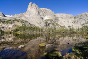
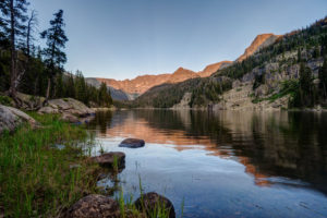
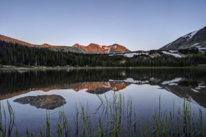
This week I hiked to Odessa Lake in Rocky Mountain National Park, a place I’d never been before. The hike starts at the Bear Lake trailhead, passing Lake Helene, and ending up at Odessa Lake. It is a beautiful but challenging 8 mile RT hike.
The first part of the trail follows Bear Lake and then quickly veers uphill after .2 of a mile. The trail climbs above Bear Lake and then veers sharply to the left. The lake is 3.6 miles from this point. For the next .5 mile, the trail heads steeply uphill through the pine forest. At this point, another trail junction makes a sharp left (toward the summit of Flattop Mountain). Ignore this junction and continue heading straight. The trail continues to climb. Soon, you will pass a clearing where views of the Mummy Range open up to the north. You will come to a large boulder field and avalanche chute that provides more open views.
The trees begin to thin at this point and views of the mountains to the west appear. The trail through this section is quite easy. The grade is only a gentle uphill slope. As views of the mountains open up, the trail makes a hard right turn. At this point (around mile 3.5), a small social trail to the left is visible. Take this trail and after .2 mile, Lake Helene awaits. It is willow choked around the shore but a few spots are accessible. Follow the indistinct social trail to the left and visit some of the open spots along the lake. Lake Helene is quite shallow so the reflections are amazing here.
After rejoining the main trail, continue heading north on the trail if you want to visit Lake Odessa. Here’s the bad news–the trail descends quite steeply about 600-800 feet to reach the lake. This means you will have to climb this steep and rocky slope on the return unless you through-hike to the Fern Lake trailhead and catch the shuttle back to Bear lake (this adds about 1-1.5 miles to the total hike). Odessa Lake is visible in a couple of spots as you descend. The trail passes the lake before backtracking to the shoreline.
Enjoy lunch at the lake! You will need to recharge your batteries before the steep uphill climb back to Lake Helene. This part of the trail took me about 45 minutes. Once you reach this spot, however, it all downhill from here. The entire hike takes about 5-5.5 hours.
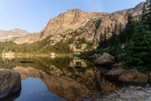
I hiked a loop from Bear Lake parking lot in Rocky Mountain National Park yesterday. I photographed the sunrise at Dream Lake and then ventured over the hill to Lake Hiyaha about 1 mile away. Although virtually at the same elevation, the two lakes are separated by a large hill that must be scaled. So the trail ascends and descends steeply form Dream Lake. Lake Hiyaha has a weird green mile color right now due to glacial sediment being disturbed. The lake itself is not very photogenic due to the presence of large boulders all along its shoreline. The tarn just in front of the lake was more photogenic in my mind. I then hiked the connector trail with the glacial gorge trail. About half a mile from the junction, there are two small tarns that are quite photogenic. I did get wet getting to the shore of one, however. It is quite the bog!
Reflection near Lake Hiyaha, Rocky Mountain National Park, CO
Dream Lake sunrise, Rocky Mountain National Park, CO
near Lake Hiyaha, Rocky Mountain National Park, CO
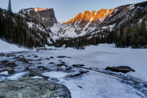
One of my favorite places to visit in Rocky Mountain National Park in winter is the trail to Dream and Emerald Lakes. The first light hits the mountains behind the lakes at just the right angle at sunrise while it takes several minutes longer to hit the peaks in other nearby valleys. I snowshoed up the short mile-long trail this week to catch the sunrise. I was not disappointed. I got good color on the peaks and even had some clouds to make for good color in the sky. I even stopped to shoot some macros of the ice on Dream Lake. The fierce winds in this area make for some spectacular patterns in the ice.
Dream Lake, sunrise, Rocky Mountain National Park, CO
Emerald Lake, sunrise, Rocky Mountain National Park, CO
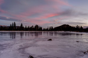
I ventured up to Sprague Lake in Rocky Mountain National Park yesterday to check out the sunrise. While the sun take a while to hit the peaks directly in back of the lake the color in the sky during a winter sunrise is spectacular. I was one of only two people at the lake so it was a peaceful, serene setting to take in a pretty sunrise as well. Since it is located off the Bear Lake road, Sprague Lake can be overrun with tourists in the summer so it was a welcome change to see so few people there.
Sunrise, Sprague Lake, Rocky Mountain National Park, CO
I backpacked to Pear Lake in the southern most part of the Wild Basin area of Rocky Mountain National Park yesterday. Pear Lake is a beautiful alpine lake and apart from the scenery offers the chance to catch native greenback cutthroat trout.
Getting to Pear Lake is something of a challenge. The lake can be reached via three different trailheads (Wild Basin, Allenspark, and Finch Lake), the shortest of which is just over 6 miles. I choose to depart from the Finch Lake trailhead, putting the trek at 6.5 miles. This trail is the most physically challenging of the three. Immediately, the trail soars 800 feet in the first .8 miles along a narrow, rocky trail. No switchbacks here as the trail climbs unrelentingly until it reaches a small saddle. The trail then meanders through a large aspen forest and wildflower meadow, a rare treat in Rocky Mountain. This is a chance to catch your breath for the next ascent. Just after intersecting with a spur of the Allenspark Trail about 1.8 miles in, the trail climbs steadily again, this time up a series of rock stairs. Just who thought it was a good idea to use 1.5 foot tall boulders as trail building material? Needless to say, this section presents a grueling uphill section.
At mile 2.5, the trail comes to a Y with the Allenspark trail and a connector to the Calypso Cascades. Over the next two miles, the trail continues to ascend but at a much more gradual pace. After some pretty views of Mount Meeker and Long’s Peak in the distance, the trail enters the forest and is fairly nondescript. Just before the 4 mile mark, the trail takes a steep descent of 300 feet into the Finch Lake basin. Nothing bad about a descent except that this section has to be climbed on the return. Finch Lake sits at 4.5 miles along the trail. It is a pretty lake surrounded by forest with a couple of peaks poking up in the distance. Follow the trail to the right as it crosses the creek and then ascends again. This section is steep but thankfully short. After reaching a lily pad pond in another mile or so, the trail flattens out before making one last ascent into the Pear Lake basin.
Here is the reward for this hard hike. Pear Lake is surrounded by mountains and is one of the prettiest in the park. It used to be much larger thanks to an earthen dam but the dam has since been removed. The lake is now about 30 feet less wide and about 6 feet less deep. And yes, there is still evidence of a bathtub ring even after the dam was removed in 1988. The lake holds a small but feisty collection of Greenback Cutthroat trout. I managed to hook a half dozen or so in my couple hours of fishing. They ranged in size from 3″ to 11″. There is one campsite above the lake which I was lucky enough to snag in the backcountry lottery in March. Photography is best here in the morning. Because Pear Lake is situated nearly east to west, the sun disappears two hours before sunset. Conversely, almost the entire lake was in sunshine just after sunrise.
Mariposa Lily, Pear Lake trail, Rocky Mountain National Park, CO
Indian Paintbrush, Pear Lake trail, Rocky Mountain National Park, CO
Columbine, Pear Lake, Rocky Mountain National Park, CO
Moonlit Pear Lake, Rocky Mountain National Park, CO
Moonlit Pear Lake, Rocky Mountain ‘n’ational Park, CO
Pear Lake, Rocky Mountain National Park, CO
Lily pond, Pear Lake trail, Rocky Mountain National Park, CO
Finch Lake, Rocky Mountain ‘n’ational Park, CO
Mountain View, Pear Lake trail, Rocky Mountain ‘n’ational Park, CO
I finally got a reservation to backpack the East Inlet Trail of Rocky Mountain National Park. Highlights include Adams Falls and a chain of five lakes. I made it to four of the lakes. My favorite was Spirit Lake. I also caught multiple brook trout in Lake Verna and Spirit Lake.
Trail Description
The trail starts out very easy. Adams Falls is accessed after about 1/3 mile on a short spur trail. It is a large cascade type waterfall. The trail continues east as it skirts the north side of a large meadow for about 2 miles. The trail here is nice and level but don’t be deceived. A steep trek awaits. About the 2.5 mile mark, you will pass the Lower East Inlet backcountry campsite. From here the trail begins to ascend steeply. Over the next mile you will learn to dread rock stairs because there are a ton of them. At the 3 mile mark, you will reach a large rock outcropping with a commanding view of Grand Lake to the west.
The trail descends about 200 feet to join up with East Inlet Creek. The trail then mellows out for the next .5 mile or so until reaching Cat’s Lair campsite. Once again the trail climbs steeply through the forest and some fine cascades can be seen along the trail. At the 5.5 mile mark, you will reach Lone Pine Lake–the first in a chain of the five lakes. If you are not a strong backpacker, it is recommended to try and reserve one of the sites near this lake for the first night on the trail.
After passing the lake, the trail once again ascends steeply through the granite slick rock face above the lake. There is a pretty waterfall shortly after passing the lake. The trail then ascends the steep cliff face on a long bench. This half mile is very steep. At the top of this stretch, you are rewarded with a commanding view of Lone Pine Lake, now about 500 feet below. The trail now follows the creek along a relatively flat street as it makes it way to Lake Verna. You will pass a small lake first that has been formed from a large rock fall damming the creek. At the 7 mile mark, you will reach Lake Verna. Here the maintained trail ends and you will have to follow the social trail to the next three lakes.
Getting up the trail is challenging as many pines have been blown over and require constant scrambling and route finding. It is best to stay along the shore of lakes and by East Inlet Creek. Spirit Lake is next up and is located about .5 mile form the east shoreline of Lake Verna. Be sure to take in the afternoon sun on the nice beach on the east short of Verna first. The views begin to open up even more as you reach Spirit Lake. This is indeed a crown jewel of this chain. I hiked up to Fourth Lake but frankly it wasn’t;t worth the effort. It is a small marshy lake that is not as interesting. If you intend to reach Fifth Lake, you have to hike through more downed timber for the next 1/2 mile before reaching the open valley where Fifth Lake is located. It looked amazing up there but I was too tired by this point to head up.
Trailhead Parking
To access the East Inlet Trail, follow the main road into
East Inlet Trail, Rocky Mountain National Park, CO
Lake Verna, East Inlet Trail, Rocky Mountain National Park, CO
East Inlet Creek, East Inlet Trail, Rocky Mountain National Park, CO
Lake Verna, East Inlet Trail, Rocky Mountain National Park, CO
The Lost Lake trail in the northeast corner of Rocky Mountain National Park provides access to a number of lakes and some good fishing. The reward after a long trek is some fine alpine scenery.
I hiked the trail to Lost Lake in one long day. It took about 10 hours to make the 9.7 mile climb up to the lake. The trail is benign for most of its journey but 2 steep sections provide for most of the 2800 foot elevation gain. The trail starts at the Dunraven trailhead north of Estes Park and spends the first half meandering through the Comanche Peak Wilderness. At the start, it descends 200 feet to the Big Thompson River and crosses the river at a newly installed bridge (the old one was washed away along with several others in the flood of 2013). The trail parallelss the river for a long flat stretch as it passes through private property. You cross the river again and pass a large horse stable. The trail stays flat for the next mile and a half as it works its way along the river.
At mile 3.5, the trail begins its steep ascent to the national park boundary. The trail climbs steeply through aspen forest and lodgepole pine. The river quickly disappears in this stretch. The trail mellows out as it reaches the boundary and passes the intersection with the Boundary Trail. The trail now follows the river for the next 1.5 miles on a fairly flat grade. Around Happily Lost Wilderness campground, the trail once again steepens around mile 6.7. You pass a junction with the Stormy Peak Pass trail and continue grinding upwards along the rocky trail. The thundering Lost Falls can be heard through the trees but to actually see it, you’ll have to cut left into the forest through downed timber just past the trail junction. Lost Falls is a pretty, 60-foot cascade, but the view is partially obscured by rocks and trees.
Back on trail, you pass a few more wilderness campsites. The trail flattens out again after Lost Meadow. The lake is now only a mile away. There are four camp sites near the lake, although none really provide a good view of it. I camped at one of the upper sites.
The lake is in a pretty basin with Rowe Peak towering in the distance. You can ascend a social trail through the trees to the left of the lake to reach the upper basin where the scenery becomes spectacular. Husted Lake and Louise Lake lie to to the south of Lost Lake in this upper basin. Unobstructed views of Rowe Peak greet the visitor. So does wind. It was unrelenting in the three days I spent in the basin. The more adventurous can even explore the Dunraven Lake basin to the east, but large snow fields blocked entrance during my visit.
The lakes in the area all support a good cutthroat trout population which proved fun to fish during my stay.
Lost Lake, Rocky Mountain National Park, CO
Wildflowers, Lost Lake trail, Rocky Mountain National Park, CO
Columbine, Lost Lake, Rocky Mountain National Park, CO
Paintbrush, Lost Lake, Rocky Mountain National Park, CO
Columbine, Lost Lake, Rocky Mountain National Park, CO
North Fork Big Thompson River, Rocky Mountain National Park, CO
Husted Lake, Rocky Mountain National Park, CO
Alpine Sunflowers, Husted Lake Basin, Rocky Mountain National Park, CO
Alpine Sunflowers, Lake Louise, Rocky Mountain National Park, CO
Columbine, Lost Lake Trail, Rocky Mountain National Park, CO
I hiked to Sky Pond in Rocky Mountain National Park earlier this week. The lake lies at the foot of the Sharksteeth, some jagged mountains near the Continental Divide in Rocky Mountain National Park. Along the way, there are numerous waterfalls to see and a couple of beautiful lakes. The trail starts at the Glacier Gorge trailhead off the Bear Lake Road. I got to the trail at 6:30 so I was able to find parking in the small lot. The first big attraction on the trail is Alberta Falls. The sun was just peeking over the canyon rim at 7:00 so it was luckily still in shade. I snapped a quick photo and then headed up the trail about 1.2 miles to where it divides with the Mills Lake trail. I veered right toward the Loch. The trail climbs steeply up some switch backs before reaching the lake in about .7 of a mile. The Loch is a pretty lake which often has nice reflections on it. It also had some nice trout surfacing so wish I had had my pole with me. I hiked onward about a mile until I came to Timberline Falls. The last .5 mile of trail went up some steep rock stairs to reach the falls. I love Timberline Falls. It is one of the prettiest waterfalls in the park. I climbed down below the first part to take in the whole falls. What a scene with the pure blue sky behind it. I then had to scramble up the right side of the falls. This isn;t normally a hard scramble but the falls were high so I got a little wet navigating them this time around. Once over the falls, I took in the scene of Lake of Glass. With the breeze picking up, it didn’t have much of a reflection per its namesake, but it was still very scenic. I then climbed above the lake to the right up in the rocks and made it the last 1/2 mile to Sky Pond. There aren;t too many lakes prettier in Colorado, that’s for sure.
Alberta Falls, Glacier Gorge Trail, Rocky Mountain National Park
Andrews Creek, Glacier Gorge Trail, Rocky Mountain National Park
The Loch, Glacier Gorge Trail, Rocky Mountain National Park, CO
Timberline Falls, Glacier Gorge Trail, Rocky Mountain National Park, CO
Black Lake in Rocky Mountain National Park is a long but rewarding hike in the Glacier Gorge area of the park. The hike features a couple of beautiful lakes (including its namesake) and several waterfalls, including the elegant Ribbon Falls. Ribbon Falls is a thin slip of a waterfall that descends a wide section of granite just below Black Lake. Along the way, hikers are treated to several other cascades along Glacier Creek.
Trail Description
The hike to Black Lake starts at the Glacier Gorge trailhead. The trail climbs steadily to Alberta Falls, about a mile up the trail. The falls thunders over the rocks. Although it’s only a 25 foot drop, the falls is quite a sight. This is the end of the road for many a hiker. But the fun is just beginning. Another small waterfall can be found just a few switchbacks up the trail. The falls is tucked into a little hidden alcove. Continuing up the trail, you reach a trail junction at mile 1.7 and bear right. The left branch heads to the boulder field atop Long’s Peak. Here, the trail cuts across a flat section of trail and approaches the canyon where lakes are located. At mile 2.2, the trail divides again–the left branch heads toward Mills and Black Lakes, the right toward the Loch. The trail climbs a series of steps and crosses the creek just before reaching Mills Lake. Mills Lake is a calm respite and provides a good spot to grab a snack near the half-way point of the hike. Try and spot a trout in its calm, shallow waters.
The trail then goes along the left side of the lake and parallels the creek for the next mile. This section of trail ascends gradually and makes its way through an area of tree blowdown. At mile 4, the trail begins to ascend more steeply. The thunderous sound of Ribbon Falls greets you at mile 4.5. This is a hard waterfall to photograph given its unique structure. Going wide here will help. You can walk off trail and reach the bottom of Ribbon Falls. The next sight is the outlet of Black Lake. The mountains in the background frame the falls beautifully. Amending the steps above the outlet, you finally reach Black Lake.
I hiked up to Fern Lake in Rocky Mountain National Park this weekend. Â I saw some beautiful waterfalls along the way and enjoyed fishing in the lake. The underbrush and ferns had started to turn so I saw some fall color as well. Unfortunately, I also dropped a neutral density filter into Fern Falls and watched it drop over a small cliff. Â Luckily, I found a game trail down to the bottom and retrieved my filter from where it had lodged the rocks. Â Thankfully, I had dropped the filter in its case so it was no worse for wear. Â Whew! Â Breakthrough filters are not cheap.
The Pool on the Big Thompson River in Rocky Mountain National Park, CO
Wildflowers, Fern Lake Trail
Fern Falls, Rocky Mountain National Park, CO
Fern Lake, Rocky Mountain National Park, CO
Fern Falls, Rocky Mountain National Park, CO
fall foliage, Fern Lake Trail
Fern Lake Trail
The trail starts at the end of the Moraine Park Road in Rocky Mountain National Park. Â Parking is scarce so get there early. Â The trail climbs gradually for the first two miles before it reaches the pool along the Big Thompson River. Â This is the first of a couple of nice waterfalls. Â Then the fun begins. Â The trial climbs steeply above the Pool for the next mile before reaching beautiful Fern Falls. Â This is one of the best falls in the park. Â I can’t wait to go back next spring when it is fuller. Â If it’s possible, the trail gets even steeper on its way to Fern Lake. Â After about a mile, it finally level off and leads to a trail divide. Â Take the short spur to Fern Lake and you will be rewarded with a beautiful spot for a picnic or fishing adventure.