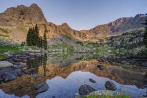
Tag: Vail

  • Pitkin Lake

    It had been about 25 years since I had been up to Pitkin Lake in the Eagles Nest Wilderness near Vail so I decided to go back this past week. Pitkin Lake is a beautiful place. The hike features a couple of waterfalls, wildflower-filled meadows, and soaring peaks. What’s not to like? The steepness of the hike, for one. This is a challenging backpack. Although the trail is listed at 4.8 miles, the trek is far longer. It gains 3,000 vertical feet and takes about 4.5 hours and about 3.75 hours going down. My guess is this hike is closer to 5.7 miles each way, almost 2 miles longer roundtrip than advertised.

    The trail starts in East Vail by crossing Pitkin Creek almost immediately. Then the fun begins, It climbs steeply over the next .5 mile, gaining about 500 feet in elevation in the process. The trail mellows out a little but and then gets pretty flat as it wanders through aspen trees. At mile 1.9 (or 2.7 in actual distance), the trail provides an overlook of a large waterfall off to the right. From here, the trail ascends at a steep incline for the next 1.5 miles before it reaches a second waterfall, this time on the left. This stretch of trail left my quads burning and required a couple of breaks. It flattens out thankfully just before coming to a second waterfall at around mile 3.5 (4.3). Access is limited due to rocks and willows. I could not get a decent photo of it. Past the waterfall, the trail ascends steeply to the right of the waterfall and then alternates steep sections with flatter ones. The trail is quite marshy through this section and is quite mosquito-filled. Finally, the trial opens up into a beautiful meadow. The flowers were just beginning to pop in this section.

    Once you get to the lake, all is forgiven, however. It is a serene setting. Colorado cutthroat trout inhabit the lake and my son and I caught a couple. /we saw no none else camped in the basin which was amazing.

    Getting to the trialhead

    Parking is limited at this trail. There are about 20 spots but they are limited to three hours (not enouh time to do even half the trail). The best course is to park near the vail transit center and catch the free East Vail hiker express. The shuttle makes a few stops at the most popular trailheads. The one for this hike is Falls at Vail. The shuttle stop is about a .25 mile downhill from the trailhead. If you are backpacking and need overnight parking, the Redstone parking garage in West Vail is your best bet. It costs $15 for the night (as opposed to $30 in the lot by the transit center). You will need to walk an additional mile to get to this garage or catch the free shuttle from the transit center.

  • Gore Lake

    Gore Lake

    Gore Lake is one of the prettiest in the Gore Range near Vail, CO. It also boasts some of the biggest trout you’ll see in an alpine environment. Which of course makes it a destination for any serious hiker, fisherman, or photographer. I happen to be all three so of course I had to visit the lake.

    The hike is 6.5 miles long and is steep in several sections. While arduous in spots, the nice thing about this trail it that it intersperses flat, level sections to allow you to catch your brief periodically. It begins at the Gore Creek trailhead off of the Big Horn Road near East Vail. The trail passes the junction with the Deluge Lake trail in about .25 mile and then climbs steeply up into the aspen forest. The aspen are dense for the first 1.5 miles and then give way to conifer forest. Around the 1.5 mile mark, the trail climbs a steep rocky section before crossing Deluge Creek over a bridge at the 2.5 mile mark. The trail passes through willow and several creeks cross the trail over the next mile. The trail now climbs steadily for the next half mile before flattening out on the approach to the trail junction at mile 5. Bear left to head to Gore Lake or stay straight if ascending the very steep Red Buffalo Pass.

    Bearing left to the lake you will pass a grave marker for two Swedes who died in the early 1900s. The next .75 mile is a lung and quad burner. It seems to head straight up the mountain in stretches. When you reach a small waterfall on your right, there is one last sharp incline before the trail flattens out in a lower meadow below the lake. You wander about .5 mile through a boggy environment as partial views of the mountains begin to open around you. Finally, the trail has one last steep section in store as it climbs the last 300 feet or so to Gore Lake over the last .5 mile. The climb is worth it as views of the peaks around the lake open all around. Look for the 18″-22″ cutthroat trout cruising the shallows of the lake. Then enjoy the fields of wildflowers to the south of the lake. This area boasts many good camping spots as well. Be sure to look for mountain goats in the area. I saw at a dozen watering about while I was there.

  • Booth Falls

    Booth Falls

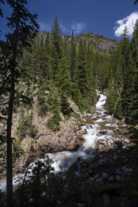
    Booth Falls is a strenuous hike to a 60 foot waterfall in the Gore Range in the Eagles Nest Wilderness near Vail, CO. The falls plunge down a steep crack at the top of a rocky canyon. Views of the cascades above the falls are easy but a steep drop over a small cliff restricts the views of the actual falls themselves.

    The hike to Booth Falls begins steeply as the trail switchbacks above the parking lot. After a half mile the trail eases a little as it follows Booth Creek. Around the 1.25 mile mark, the trail then climbs very steeply up to a rocky bench as ascends through an avalanche zone filled with raspberry and huckleberry bushes. The falls is located off the left side of the trail just past the 2.0 mark. Expect it take 1.5 hours to reach the falls. The trail continues above the falls, reaching Booth Lake in about 5 miles from the trailhead.

    To get to the trailhead, take I-70 to Exit 180 in East Vail. Turn right at the exit and then make a left on the frontage road. Drive for a mile and then turn right at the sign for the falls. If the main lot is full, overflow parking can be usually found at the Vail Mountain School just down the rod.

  • Shrine Ridge Wildflowers

    Shrine Ridge

    I backpacked to the summit of Shrine Ridge near Vail, CO.  The wildflowers were bountiful again this year although not quite as good as last year.  Lupine and red paintbrush were the predominant varieties with some alpine sunflowers and others mixed in.  I camped near the top so I could do some night photography in the moonlight and catch sunrise on the ridge.  A thunderstorm hung around until after midnight so I had to wait a while before the moon came out.  I was rewarded with some fantastic photo ops when the moon finally emerged.  Although I could not see all the flowers, the meadow was filled with flowers.  Once the sun came up, I was amazed with the color and variety of flowers.

    Trail directions

    Shine Ridge is located at the summit of Vail Pass, 10 miles east of Vail.  Take the exit for the rest area at the summit and drive on the dirt road to the right for about 2.5 miles.  Park at the trail head (get there early because the lot fills quickly).  The trail begins by wandering through willow in a boggy area.  It climbs past a small pond and then climbs steeply past some meadows of paintbrush.  As you climb, you will cross a small creek.  Stay on the main trail at the 1 mile marker where it meets a spur trail leading from a mountain inn.  After about 1.25 miles, the trail flattens out briefly as you reach the base of the ridge.  Snow cornices linger here well into summer.  The trail veers right and climbs again steeply up to the ridge.  At the summit, veer right and explore the wildflower-filled meadow.  Views of the Holy Cross Wilderness open up to the west.

Plugin from the creators ofBrindes Personalizados :: More at PlulzWordpress Plugins