Category: Uncategorized

  • Cirque of the Towers

    Cirque of the Towers

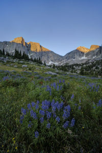
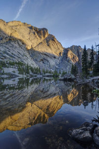
    My family and I recently backpacked to the Cirque of the Towers in the Wind River range of Wyoming. It is an amazing place where a lake is encircled by high peaks in a glacial basin. The Cirque had been on my radar as a place to visit for many years now so I’m glad I finally had a chance to get there. It was a rough hike but the effort was worth it. As an added bonus, I got to see the comet Neowise peaking out just above the horizon line one evening.

    The hike to the Cirque begins at the Big Sandy trailhead near the southern end of the range. The first section of the hike is a relatively easy jaunt to Big Sandy Lake, five miles from the trailhead. The trail begins by going through the forest before reaching a meadow around the .5 mile mark. From there, the trail begins to ascend up some switchbacks and then levels out around the two mile mark at another large meadow. Here, you begin to see views of the surrounding mountains. The trail again climbs gradually through the trees until arriving at the shores of Big Sandy Lake around mile 5. This is a good place to camp for the night or you can continue up the trail 1.5 to the incomparable Clear Lake.

    The trail skirts the left side of the lake, crosses a small stream, and reaches the junction with the Big Sandy trail to Jackass Pass at mile 5.5. The fun now begins. You gain 1700 feet in elevation in 3 miles but also lose 600 feet of elevation. For the junction, the trail immediately ascends via steep switchbacks to a beautiful meadow. It levels off for the half mile, reaching a small stream and pool. The trail crosses the creek and ascends via steep switchbacks. You climb 300 feet but then descend all 300 feet to the inlet of North Lake. Take a rest here because the trail now ascends up a steep slope through the rocks above Arrowhead Lake. It soon comes to a trail junction with the Arrowhead Lake climbing route. Go right and head up through the boulders above Arrowhead Lake. Here you begin to glimpse the amazing scenery of the area. Peaks soar around you. When you reach the high point, your heart sinks as you can now see the trail drops most of the way down to Arrowhead Lake before reascending to Jackass Pass. The trail splits in three after the descent, as the left branch descends the rest of the way to Arrowhead Lake, the central branch leads to the base of Cirque, and the right branch ascends the pass. Take the right fork and do one more steep climb before you finally reach the summit of the pass.

    At the pass, take in the view. The peaks of the Cirque of the Towers surround you and Lonesome Lake can be seen far below you. Peaks such as the Wolf’s Head, Shark Nose, and Pingora Peak cut a distinct profile. Follow the trail down toward the lake. You can proceed left to a large waterfall and the head of the basin or you can go right and camp past the lake and continue on the trail toward Papoose Lake. I camped in the area above the basin so I could visit the lake and waterfall. The lake contains many small cutthroat trout which are willing biters.

  • Willow Lake-Sangre de Cristo

    Willow Lake-Sangre de Cristo

    My boys and I backpacked to Willow Lake in the Sangre de Cristo mountain range near Crestone, CO last weekend. It is a challenging hike, but the beautiful lake at the end of the hike makes it a rewarding one. It is surrounded by mountains in a narrow bowl including Kit Carson and Challenger peaks, two fourteeners. The trail climbs 2900 feet in 5 miles and is not for the faint of heart.

    The hike begins by climbing steadily up switchbacks through aspen and coniferous forest. After a mile, the switchbacks steepen as the trail climbs to a meadow (this is the second hardest portion of the hike). Views of Kit Carson peak open up here. Catch your breath as the next half mile is the only easy section of trail. The trail descends near the meadow and then begins a steady climb upward. More switchbacks await as you climb through the forest. Around the 2.5 mile mark, you will pass a large campsite on the left. The trail continues up switchbacks until leveling off briefly at a stream crossing at mile 3.5. Rest here and take in the pretty waterfall because the next half mile is the steepest of the trail. The trail climbs up through rock scree as it scales a sheer rock face. This section was as steep as any mountain pass I’ve climbed.

    The demoralizing aspect of the trail hits you in the last section. You’d think you’d be done after the last ascent, but there is still another mile to go with yes more switchbacks. You finally arrive at a meadow below Willow Lake where camping is allowed. No camping is allowed at the lake itself. The meadow will be crowded as climbers hiking Kit Carson and Challenger use it as a base camp.

    Finally, if you want to visit Willow Lake climb past the meadow on a steep, rocky path. A social trail through downed timber skirts some of the shoreline. Great views await at the lake with a waterfall draining into the back of the lake as an added bonus. The reflections in the lake were amazing near sunset. The only drawback is that very little of the surrounding mountains are lit with sunlight as the bowl faces diagonally and not much direct sunlight hits the basin. Also, don’t expect to find many fish in the lake. I saw only one brook trout.

    Getting There

    To reach the trailhead for Willow Lake (or South Crestone Lake), take Highway 17 to Moffat (between ALamosa and Salida) and turn east onto County Road T. Follow the road to the town of Crestone and then follow the signs for the Willow trailhead. A rough two mile dirt road takes you to the trailhead. A small parking lot holds about 30 cars, so be prepared to park down the road during busy days.

  • Booth Falls

    Booth Falls

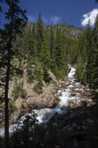
    Booth Falls is a strenuous hike to a 60 foot waterfall in the Gore Range in the Eagles Nest Wilderness near Vail, CO. The falls plunge down a steep crack at the top of a rocky canyon. Views of the cascades above the falls are easy but a steep drop over a small cliff restricts the views of the actual falls themselves.

    The hike to Booth Falls begins steeply as the trail switchbacks above the parking lot. After a half mile the trail eases a little as it follows Booth Creek. Around the 1.25 mile mark, the trail then climbs very steeply up to a rocky bench as ascends through an avalanche zone filled with raspberry and huckleberry bushes. The falls is located off the left side of the trail just past the 2.0 mark. Expect it take 1.5 hours to reach the falls. The trail continues above the falls, reaching Booth Lake in about 5 miles from the trailhead.

    To get to the trailhead, take I-70 to Exit 180 in East Vail. Turn right at the exit and then make a left on the frontage road. Drive for a mile and then turn right at the sign for the falls. If the main lot is full, overflow parking can be usually found at the Vail Mountain School just down the rod.

  • Caitlin and Zach Engagement Session

    Caitlin and Zach Engagement Session

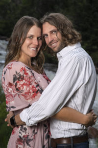
    I had the pleasure of photographing an engagement session for Caitlin and Zach at Eldorado Canyon State Park this week. They are a fun couple to work with and I always enjoy meeting another social studies teacher. Go Caitlin!

    Caitlin and Zach are getting married next summer at the Elizabeth Hotel in Old Town Fort Collins. They have a great story to tell. Like many couples, they met in 2013 through mutual friends. However, it wasn’t until 2016 that they officially started dating after Zach asked her to be his date to his brother’s wedding. Since then, they have been inseparable, traveling to Europe to see Ireland, Northern Ireland, Scotland, Croatia, Greece and Germany.

    After four years of dating, Zach proposed on their 4th anniversary. After a night out for dinner and drinks, Caitlin walked in the house to discover rose petals and candles everywhere. That’s when Zach got down on one knee and asked her to marry him! According to Caitlin, it was the easiest question she’s ever been asked!

    When not working or traveling, Caitlin and Zach are both fitness nuts. They’ve done 2 half ironmans together, as well as many other triathlons, tough mudders, 10ks and 5ks.

    Their wedding will take place on June 26, 2021 in Fort Collins, CO. Since they are both CSU grads, it seemed the perfect choice. Family will play a big role in their wedding as Caitlin’s brother will officiate and Zach’s brother will be his best man. Best wishes to a fun couple that was a lot of fun to work with.  

  • San Rafael Swell

    San Rafael Swell

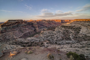
    The San Rafael Swell covers a large area of southern Utah. It runs from just north of Capitol Reef National Park northward along a narrow spine towards the town of Price. Along the way, myriad canyons and other weird features dot the landscape. I visited a few of the hallmarks of the area on a recent trip before my camera was stolen. Luckily, I have some images from my drone and backup camera to preserve the memories of a very interesting place.

    Wedge Overlook

    Now that the shelter in place restrictions have been eased somewhat for travel to Utah, I took advantage of the slow time on my calendar and visited a place I have been meaning to get to for the past five years. The Wedge Overlook looks out over the San Rafael River as it winds through Utah’s Little Grand Canyon. It offers a spectacular view of the river canyon below and it a great place to camp and watch a sunset. The Wedge is fairly unknown thanks to its somewhat remote location off off I-70. That said, there were still 30 or so people camped out on a Monday in May so you won’t be alone, either. It is about 30 miles north of I-70 and fifteen miles east of the town of Castledale. It can be reached either from the east or west, depending on how much dirt road you want to travel. Take I-70 to exit 99 and head north to Emery and then Castledale. Turn right onto a well-marked and smooth dirt road just north of Castledale (Green River Cutoff). After 13 miles, turn right on the road to the Wedge (you’ll pass a large picnic shelter and parking lot). Go six miles to the end of the road. Ten primitive camping sites are available along the road (plus other unofficial ones). Alternatively, you can take the Buckhorn Draw Road north to the Green River Cutoff. This road is located at exit 131 (previously marked exit 129). This is a much rougher and narrower dirt road so the 20 mile drive north will take longer. Whichever way you go, be sure to check out the Buckhorn Draw petroglyph panel. It is spectacular, located on the Buckhorn Draw Road, just a couple of miles south of the Green River Cutoff.

    Goblin Valley

    Goblin Valley State Park features some short hoodoos (weathered sandstone blobs) that make for some good photography subjects. Limited camping is available in the park but many primitive sites are available just outside the park on either Temple Mountain Road or Behind the Swell Road. The hoodoos can be reached via a short hike from the parking lot. Head toward the large green “mountain” straight out from the parking lot. The best collection of hoodoos can be seen from here.

    Crack Canyon

    Crack Canyon is an interesting slot canyon located just off Behind the Swell Road near Goblin Valley State Park. The Canyon does not feature the incredible narrows of other nearby canyons such as Little Wild Horse but it does have really interesting rock formations. It also has the namesake “crack” located about a mile from the trailhead. About 2.5 miles of the canyon can be easily hiked but then you have to slide down a rope down a 10 foot drop. It is easy to get up the rope but not so easy to get down, especially with a pack on. I turned around here but other hikers successfully slid down. Crack Canyon provides a nice alternative to the more well known Little Wild Horse slot. I ended up here because Little Wild Horse was closed due to a search and recovery action. Two girls died in a flash flood there the day before I came. So as always, be aware of the weather when entering any slot canyon. The danger of flash flooding is real.

    To reach Crack Canyon, take the Temple Mountain road and go north from Goblin Valley. After a couple of miles, go left on Behind the Swell Road. This is a fairly rough road, so 4×4 may be advised. Go four miles and the trailhead is on the left. The trail follows an old road at the start and then enters the wash of the canyon. Follow the wash down the canyon. There is one spot where you will have to go around a rock fall. Be cognizant of your surroundings so you can find your way back. There are some false trails I found myself unintentionally exploring.

    The rest of the Swell has countless interesting formations to check out along with several petroglyph panels and other rock art. The Buckhorn Draw Road featured some interesting rock formations and buttes. I flew my drone over a couple to get a closer view. There were also a number of wildflowers blooming in the open spaces. I took a quick detour to check out the Head of Sinbad petroglyphs. They were not that interesting. It featured only two small panels. If you want to see them, take Temple Mountain Road south from I-70 and then turn off toward the Head of Sinbad. A small side road goes under I-70 and back about a mile on the north side of the highway to access the side of the butte to view the rock art (4×4 is necessary to get through the sandy conditions).

    I drove the length of the Temple Mountain Road from I-70 and most of it is uninteresting. However, about 10 miles north of Goblin Valley the scenery gets more diverse and you are rewarded with some wide-open views of the area.

  • Epic Model Home Anthem Reserve

    Epic Model Home Anthem Reserve

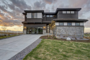
    I had the opportunity to photograph the Epic Homes Pinnacle model home at Anthem Reserve near my home in Broomfield, CO. Thanks to Epic Homes for letting me photograph their beautiful show home. I photographed each room and also put together a 360 virtual tour, composed of 22 panoramic photographs. The virtual tour is hosted on Kuula.co.

    The Pinnacle model is the largest of the homes Epic is building in Anthem Reserve located at the intersection of Lowell Blvd and Sheridan Parkway. It is 4,170 sq. ft with approximately an additional 1,500 sq. ft in the basement. It features a great room and an elegant master suite. The model is a garden level and looks out over the mountains. Anthem Reserve sits on one of the highest points in Broomfield, so it has stunning views of the Front Range. Lots are larger in the Reserve as well, ranging from 10,500-12,500 sq. ft.

    Epic Homes is an independent home builder based in Denver owned by Chris Presley. More information on their homes can be found at Epic’s website.

  • HDR vs Flash/Ambient Blend in Real Estate Photography

    HDR vs Flash/Ambient Blend in Real Estate Photography

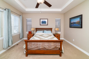
    Taking good photographs of real estate is challenging because of the high degree of dynamic range (the difference between lights and darks) in the scene. If the photographer exposes for the scene out the windows, the interior will likely be too dark. Conversely, if the photographer exposes for the interior, the windows will be blown out. Here is an example of what I mean. In the first photo, the window looks great but the interior is dark. In the second photo, the reverse is true.

    master bedroom, ambient exposure, real estate photography, residential, broomfield, colorado
    Master bedroom ambient light exposed for window
    master bedroom, ambient exposure, real estate photography, residential, broomfield, colorado
    Master bedroom, ambient light exposed for room

    Many real estate photographers offer HDR (high dynamic range) blending as a way to compensate for the issue of dynamic range. While it does make the resulting photo look more like our eye or our brain would envision the scene, it doesn’t fix all problems. Let’s look at the photo below. While it is certainly better than the above two examples, it is far from perfect. The color is off, and not all parts of the bedroom are evenly lit. Some are still in deep shadow.

    master bedroom, HDR, real estate photography, broomfield, colorado
    Master bedroom, HDR blend of 3 exposures

    This points to a second problem with lighting in most real estate scenes is–it is coming from multiple sources. Daylight or ambient light is often pouring in from the windows and mixing with artificial lighting inside. What you get is a something of a lighting Frankenstein. To fix this problem, a photographer can use flash to overpower the ambient and artificial light in the room and get a much more even color cast throughout the room. For this scene, I positioned two flashes a little behind and to either side of the camera. They are pointed up toward the ceiling and angled back a little. I put them about 3 feet below the ceiling to get the best bounce from the ceiling. Another benefit of using flash is that the window scene can be properly exposed for while still lighting the interior of the room. Sometimes, however, this can give a somewhat flat or fake look to the photos. Thus, the best solution is to blend the flash photo with a little bit of the ambient light from the HDR blend to get the best of both worlds. Now, the scene is evenly lit, the color is consistent, and some directionality of light can still be seen.

    flambient, HDR flash blend, master bedroom, Colorado, Broomfield, real estate photography
    Master bedroom, HDR/flash blended exposure
    HDR, flash, blended exposure, flambient, real estate photography, interior, master bedroom, broomfield, colorado
    master bedroom, HDR/flash blended exposure
    HDR, flash, blended exposure, flambient, real estate photography, interior, master bedroom, broomfield, colorado
    HDR/flash blended exposure

    While it takes a little more effort than simply bracketing exposures and using HDR processing, the results speak for themselves. You get a higher quality image to deliver to your client.

  • Wedding Styled Shoot The Chateaux at Fox Meadows

    I recently photographed a wedding styled shoot at The Chateaux at Fox Meadows in Broomfield, CO. A styled shoot is a photography session using models rather than real couples. It’s a great opportunity for a photographer to try new techniques and get to work with professional models. A big thank you goes to the Chateaux at Fox Meadows for hosting the event and Dani West Bridal in Erie for lending the wedding gown. Another big thank you goes to Caitlin Quisenberry of Nxt Model and Clay Lucas at Barbizon Modeling College in Denver. They did a fantastic job and made my job a lot easier. Finally, Williams Jewelers in Cherry Creek provided sample rings, and Lafayette Florist was able to provide a beautiful bouquet.

    I chose to photograph the session at the Chateaux because of the interesting architecture of the venue and the number of cool spaces to photograph in. What wedding photographer can resist a giant spiral staircase and large colonnades? I like to add elements of fashion photography to my portraits and this is the perfect venue to complement my style of photography. I love showing off the architecture to help tell the story of the wedding.

    The Chateaux features a number of cool locations to photograph, including the bridal suite complete with mirror and clocks, three balconies, an outdoor courtyard, and the aforementioned grand staircase.

    For the shoot, I used a Sony a7r mkiv camera coupled with an 85mm f 1.4 Sony lens. I also used two Bowens XMT 500 strobes with shoot through umbrella and a strip box.

    If you are in need of a wedding photographer in Colorado, contact me at 3030 478 7586.

  • 4A CHSAA Softball Finals 2019

    The Erie High School softball team got hot at the right time. Ranked as only a #14 seed entering the Colorado State High School softball tournament, Erie faced long odds to capture its 12th title. But after defeating defending champion Holy Family (#2 seed) and Golden (#1 seed), Erie earned every bit of its record 12th title. Using the long ball 4 times, Erie prevailed 13-9 in eight innings.

  • Colorado Fall Color 2019

    I spent 4 days in the Colorado high country last week. The aspen were at peak or just beginning to turn in some places. Grand Mesa and Boreas Pass were the best spots to catch fall color.

    Aspen

    Maroon Bells had some nice aspen but the area was not at peak yet. The water in Maroon Lake was unusually low so it made for bad reflection photos. I did get to see a beautiful sunrise at the start of the Capitol Peak trail.

    Grand Mesa

    I found a couple of nice spots to see fall color on the Grand Mesa near Grand Junction, CO. The best seemed to be around Lake.

    Boreas Pass

    The aspen were turning near peak color last weekend on Boreas Pass near Breckenridge.


    Flattops

    I took a drove through the flattops. While the aspen had not yet turned, the scrub oak were amazingly vibrant.

Plugin from the creators ofBrindes Personalizados :: More at PlulzWordpress Plugins