The San Rafael Swell covers a large area of southern Utah. It runs from just north of Capitol Reef National Park northward along a narrow spine towards the town of Price. Along the way, myriad canyons and other weird features dot the landscape. I visited a few of the hallmarks of the area on a recent trip before my camera was stolen. Luckily, I have some images from my drone and backup camera to preserve the memories of a very interesting place.
Wedge Overlook
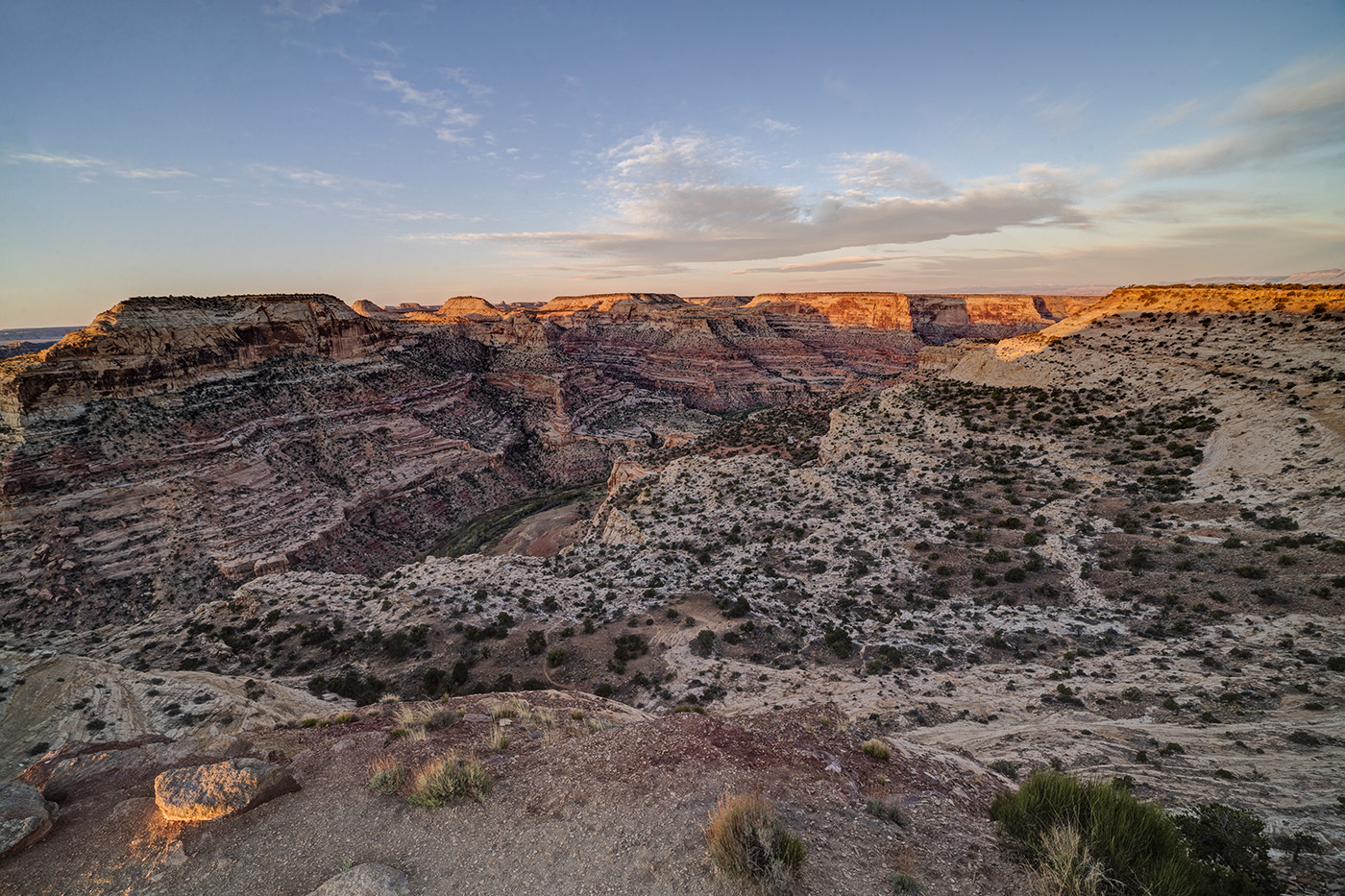
Now that the shelter in place restrictions have been eased somewhat for travel to Utah, I took advantage of the slow time on my calendar and visited a place I have been meaning to get to for the past five years. The Wedge Overlook looks out over the San Rafael River as it winds through Utah’s Little Grand Canyon. It offers a spectacular view of the river canyon below and it a great place to camp and watch a sunset. The Wedge is fairly unknown thanks to its somewhat remote location off off I-70. That said, there were still 30 or so people camped out on a Monday in May so you won’t be alone, either. It is about 30 miles north of I-70 and fifteen miles east of the town of Castledale. It can be reached either from the east or west, depending on how much dirt road you want to travel. Take I-70 to exit 99 and head north to Emery and then Castledale. Turn right onto a well-marked and smooth dirt road just north of Castledale (Green River Cutoff). After 13 miles, turn right on the road to the Wedge (you’ll pass a large picnic shelter and parking lot). Go six miles to the end of the road. Ten primitive camping sites are available along the road (plus other unofficial ones). Alternatively, you can take the Buckhorn Draw Road north to the Green River Cutoff. This road is located at exit 131 (previously marked exit 129). This is a much rougher and narrower dirt road so the 20 mile drive north will take longer. Whichever way you go, be sure to check out the Buckhorn Draw petroglyph panel. It is spectacular, located on the Buckhorn Draw Road, just a couple of miles south of the Green River Cutoff.

Wedge Overlook, Little Grand Canyon, San Rafael Swell, Utah,

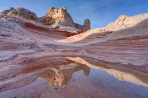
Wedge Overlook, San Rafael Swell, Emery County, UT

Wedge Overlook, San Rafael Swell, Emery County, UT

Wedge Overlook, San Rafael Swell, Emery County, UT

Wedge Overlook, San Rafael Swell, Emery County, UT

Wedge Overlook, Little Grand Canyon, San Rafael Swell, Utah
Goblin Valley
Goblin Valley State Park features some short hoodoos (weathered sandstone blobs) that make for some good photography subjects. Limited camping is available in the park but many primitive sites are available just outside the park on either Temple Mountain Road or Behind the Swell Road. The hoodoos can be reached via a short hike from the parking lot. Head toward the large green “mountain” straight out from the parking lot. The best collection of hoodoos can be seen from here.

Goblin Valley State Park, UT

Goblin Valley State Park, UT

Goblin Valley State Park, UT

Goblin Valley State Park, UT
Crack Canyon
Crack Canyon is an interesting slot canyon located just off Behind the Swell Road near Goblin Valley State Park. The Canyon does not feature the incredible narrows of other nearby canyons such as Little Wild Horse but it does have really interesting rock formations. It also has the namesake “crack” located about a mile from the trailhead. About 2.5 miles of the canyon can be easily hiked but then you have to slide down a rope down a 10 foot drop. It is easy to get up the rope but not so easy to get down, especially with a pack on. I turned around here but other hikers successfully slid down. Crack Canyon provides a nice alternative to the more well known Little Wild Horse slot. I ended up here because Little Wild Horse was closed due to a search and recovery action. Two girls died in a flash flood there the day before I came. So as always, be aware of the weather when entering any slot canyon. The danger of flash flooding is real.
To reach Crack Canyon, take the Temple Mountain road and go north from Goblin Valley. After a couple of miles, go left on Behind the Swell Road. This is a fairly rough road, so 4×4 may be advised. Go four miles and the trailhead is on the left. The trail follows an old road at the start and then enters the wash of the canyon. Follow the wash down the canyon. There is one spot where you will have to go around a rock fall. Be cognizant of your surroundings so you can find your way back. There are some false trails I found myself unintentionally exploring.

The Crack, Crack Canyon, San Rafael Swell, UT

The Crack, Crack Canyon, San Rafael Swell, UT

Crack Canyon, San Rafael Swell, UT

Crack Canyon, San Rafael Swell, UT

Crack Canyon, San Rafael Swell, UT

Crack Canyon, San Rafael Swell, UT

Crack Canyon, San Rafael Swell, UT

Crack Canyon, San Rafael Swell, UT

Crack Canyon, San Rafael Swell, UT

Crack Canyon, San Rafael Swell, UT

Crack Canyon, San Rafael Swell, UT

Crack Canyon, San Rafael Swell, UT

Crack Canyon, San Rafael Swell, UT
The rest of the Swell has countless interesting formations to check out along with several petroglyph panels and other rock art. The Buckhorn Draw Road featured some interesting rock formations and buttes. I flew my drone over a couple to get a closer view. There were also a number of wildflowers blooming in the open spaces. I took a quick detour to check out the Head of Sinbad petroglyphs. They were not that interesting. It featured only two small panels. If you want to see them, take Temple Mountain Road south from I-70 and then turn off toward the Head of Sinbad. A small side road goes under I-70 and back about a mile on the north side of the highway to access the side of the butte to view the rock art (4×4 is necessary to get through the sandy conditions).
I drove the length of the Temple Mountain Road from I-70 and most of it is uninteresting. However, about 10 miles north of Goblin Valley the scenery gets more diverse and you are rewarded with some wide-open views of the area.