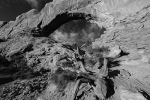
I took a trip out to Arches and Canyonlands National Parks recently. While I was there, I focused on subjects that might make for some interesting black and white compositions. I always look for dead trees, interesting lines, or areas of stark contrast. These often make great black and white images. I also like shooting black and whites outside the golden hours since the sky tends to turn a dark blue and will render as black. Arches National Park and the area surrounding Moab, UT is a great place to find such subjects.
The Windows area in Arches has plenty of good subject matter. Arches, dead trees, and other natural features abound. I also spent some time hiking the Corona Arch trail and the area around Aztec Butte in Canyonlands National Park.
Kane Creek, Moab, UT
Corona Arch trail, Moab, UT
Dead tree near Broken Arch, Arches National Park, UT
Dead Tree along the trail to Landscape Arch, Arches National Park, UT
Corona Arch, Moab, UT
View from Aztec Butte, Canyonlands National Park, UT
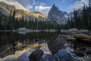
Gore Lake is one of the prettiest in the Gore Range near Vail, CO. It also boasts some of the biggest trout you’ll see in an alpine environment. Which of course makes it a destination for any serious hiker, fisherman, or photographer. I happen to be all three so of course I had to visit the lake.
The hike is 6.5 miles long and is steep in several sections. While arduous in spots, the nice thing about this trail it that it intersperses flat, level sections to allow you to catch your brief periodically. It begins at the Gore Creek trailhead off of the Big Horn Road near East Vail. The trail passes the junction with the Deluge Lake trail in about .25 mile and then climbs steeply up into the aspen forest. The aspen are dense for the first 1.5 miles and then give way to conifer forest. Around the 1.5 mile mark, the trail climbs a steep rocky section before crossing Deluge Creek over a bridge at the 2.5 mile mark. The trail passes through willow and several creeks cross the trail over the next mile. The trail now climbs steadily for the next half mile before flattening out on the approach to the trail junction at mile 5. Bear left to head to Gore Lake or stay straight if ascending the very steep Red Buffalo Pass.
Bearing left to the lake you will pass a grave marker for two Swedes who died in the early 1900s. The next .75 mile is a lung and quad burner. It seems to head straight up the mountain in stretches. When you reach a small waterfall on your right, there is one last sharp incline before the trail flattens out in a lower meadow below the lake. You wander about .5 mile through a boggy environment as partial views of the mountains begin to open around you. Finally, the trail has one last steep section in store as it climbs the last 300 feet or so to Gore Lake over the last .5 mile. The climb is worth it as views of the peaks around the lake open all around. Look for the 18″-22″ cutthroat trout cruising the shallows of the lake. Then enjoy the fields of wildflowers to the south of the lake. This area boasts many good camping spots as well. Be sure to look for mountain goats in the area. I saw at a dozen watering about while I was there.
Gore Lake, Eagles Nest Wilderness, Vail, CO
Purple Mountain aster wildflowers, Gore Lake, Eagles Nest Wilderness, Vail, CO
Wildflowers, Gore Lake, Eagles Nest Wilderness, Vail, CO
Gore Lake, Eagles Nest Wilderness, Vail, CO
cutthroat trout, Gore Lake, Eagles Nest Wilderness, CO
Mountain goats, Gore Lake, Eagles Nest Wilderness, CO
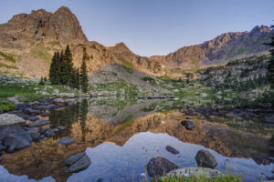
The views from Crater Lake and Mirror Lake in the Indian Peaks Wilderness are some of the most iconic views in the Colorado mountains. I was excited to finally get a chance to see them on a recent backpacking trip with my sons. The area didn’t disappoint. Several fine waterfalls can be viewed along the Cascade Creek trail en route to the lakes. Both lakes are beautiful in their own right but the view from Mirror Lake with Lone Eagle Peak soaring behind it makes for a stunning photograph.
The trail begins at the Monarch Lake trailhead at the back end of Granby Reservoir. It follows the north shoreline of Monarch Lake before entering the wilderness around mile 1.2. The trail reaches its first branch at mile 1.6 as the Arapaho Pass trail connects off to the right. Stay on the main trail and pass over Buchanan creek a bridge just over the 2 mile mark. The trail then begins to climb up switchbacks for a half mile or so before flattening out on its way to the junction with the Buchanan Pass trail. Bear right onto the Cascade Creek trail and cross over a bridge near the confluence of the two creeks. The trail climbs steeply to the first of many cascades. This one is notable for the narrow, rocky canyon it pours out from.
The trail climbs again and you come to another bridge at 4.4 miles. Shortly thereafter, you come to the first of four cascades which comprise Cascade Falls. The trail becomes steep and rocky at this point as it winds its way past each of the four falls. The last one is located in an open valley at mile 5.2. The trail now opens into a large meadow filled with wildflowers in July. Several columbine paintbrush, and larkspur dot the hillside. This is a great spot for a rest as the trail begins a steep climb toward the junction with the Pawnee Pass trail. You reach the junction at mile 6.4. Pawnee Pass is to the left. Bear right and head toward the lake basin. The trail becomes very rocky here and quickly enters what looks like an abandoned stream bed. Climb up the narrow canyon and you come out atop a large rock slab. The area is marked with cairns.
After a short jaunt through open forest, the trail again crosses Cascade Creek over a relatively new bridge at mile 7.4. You’re almost to Mirror Lake but you need to scale some switchbacks first. Finally, the epic view from the shore of Mirror Lake awaits around mile 7.8. Lone Eagle Peak’s pointed spire towers straight in front of you. If you’re spending the night, find an open campsite if you have the necessary reservation. There are 12 campsites in all between Mirror Lake and Crater Lake. Follow the trail to the left around the west side of the lake. It becomes very hard to follow in spots but just keep heading in this direction. Once you pass the far shore of the lake, you will come to a reflecting tarn with an amazing view of Lone Eagle Peak. Follow the trail around to the right and up over a large rock outcropping. Finally, you’ve reached the end of the trail at Crater Lake.
I found sunset to be the the best time to shoot Mirror Lake but an hour after sunrise is also good. Crater Lake is best at sunrise.
Cascade Creek, Indian Peaks Wilderness, CO
Mirror Lake, Indian Peaks Wilderness, CO
Mirror Lake and Lone Eagle Peak, Indian Peaks Wilderness, CO
Mirror Lake, Indian Peaks Wilderness, CO
Reflecting Tarn, sunset, near Crater Lake, Indian Peaks Wilderness, CO
Crater Lake, Indian Peaks Wilderness, CO
Reflecting tarn, Lone Eagle Peak, Indian Peaks Wilderness, CO
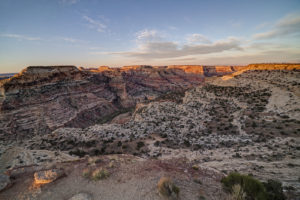
The San Rafael Swell covers a large area of southern Utah. It runs from just north of Capitol Reef National Park northward along a narrow spine towards the town of Price. Along the way, myriad canyons and other weird features dot the landscape. I visited a few of the hallmarks of the area on a recent trip before my camera was stolen. Luckily, I have some images from my drone and backup camera to preserve the memories of a very interesting place.
Wedge Overlook
Now that the shelter in place restrictions have been eased somewhat for travel to Utah, I took advantage of the slow time on my calendar and visited a place I have been meaning to get to for the past five years. The Wedge Overlook looks out over the San Rafael River as it winds through Utah’s Little Grand Canyon. It offers a spectacular view of the river canyon below and it a great place to camp and watch a sunset. The Wedge is fairly unknown thanks to its somewhat remote location off off I-70. That said, there were still 30 or so people camped out on a Monday in May so you won’t be alone, either. It is about 30 miles north of I-70 and fifteen miles east of the town of Castledale. It can be reached either from the east or west, depending on how much dirt road you want to travel. Take I-70 to exit 99 and head north to Emery and then Castledale. Turn right onto a well-marked and smooth dirt road just north of Castledale (Green River Cutoff). After 13 miles, turn right on the road to the Wedge (you’ll pass a large picnic shelter and parking lot). Go six miles to the end of the road. Ten primitive camping sites are available along the road (plus other unofficial ones). Alternatively, you can take the Buckhorn Draw Road north to the Green River Cutoff. This road is located at exit 131 (previously marked exit 129). This is a much rougher and narrower dirt road so the 20 mile drive north will take longer. Whichever way you go, be sure to check out the Buckhorn Draw petroglyph panel. It is spectacular, located on the Buckhorn Draw Road, just a couple of miles south of the Green River Cutoff.
Wedge Overlook, Little Grand Canyon, San Rafael Swell, Utah,
Wedge Overlook, San Rafael Swell, Emery County, UT
Wedge Overlook, Little Grand Canyon, San Rafael Swell, Utah
Goblin Valley
Goblin Valley State Park features some short hoodoos (weathered sandstone blobs) that make for some good photography subjects. Limited camping is available in the park but many primitive sites are available just outside the park on either Temple Mountain Road or Behind the Swell Road. The hoodoos can be reached via a short hike from the parking lot. Head toward the large green “mountain” straight out from the parking lot. The best collection of hoodoos can be seen from here.
Goblin Valley State Park, UT
Crack Canyon
Crack Canyon is an interesting slot canyon located just off Behind the Swell Road near Goblin Valley State Park. The Canyon does not feature the incredible narrows of other nearby canyons such as Little Wild Horse but it does have really interesting rock formations. It also has the namesake “crack” located about a mile from the trailhead. About 2.5 miles of the canyon can be easily hiked but then you have to slide down a rope down a 10 foot drop. It is easy to get up the rope but not so easy to get down, especially with a pack on. I turned around here but other hikers successfully slid down. Crack Canyon provides a nice alternative to the more well known Little Wild Horse slot. I ended up here because Little Wild Horse was closed due to a search and recovery action. Two girls died in a flash flood there the day before I came. So as always, be aware of the weather when entering any slot canyon. The danger of flash flooding is real.
To reach Crack Canyon, take the Temple Mountain road and go north from Goblin Valley. After a couple of miles, go left on Behind the Swell Road. This is a fairly rough road, so 4×4 may be advised. Go four miles and the trailhead is on the left. The trail follows an old road at the start and then enters the wash of the canyon. Follow the wash down the canyon. There is one spot where you will have to go around a rock fall. Be cognizant of your surroundings so you can find your way back. There are some false trails I found myself unintentionally exploring.
The Crack, Crack Canyon, San Rafael Swell, UT
Crack Canyon, San Rafael Swell, UT
The rest of the Swell has countless interesting formations to check out along with several petroglyph panels and other rock art. The Buckhorn Draw Road featured some interesting rock formations and buttes. I flew my drone over a couple to get a closer view. There were also a number of wildflowers blooming in the open spaces. I took a quick detour to check out the Head of Sinbad petroglyphs. They were not that interesting. It featured only two small panels. If you want to see them, take Temple Mountain Road south from I-70 and then turn off toward the Head of Sinbad. A small side road goes under I-70 and back about a mile on the north side of the highway to access the side of the butte to view the rock art (4×4 is necessary to get through the sandy conditions).
I drove the length of the Temple Mountain Road from I-70 and most of it is uninteresting. However, about 10 miles north of Goblin Valley the scenery gets more diverse and you are rewarded with some wide-open views of the area.
Boulder sets its all-time record for snowfall in a winter with this past storm. The spring snow storm dumped 15 inches on the city bringing the annual total to 151 inches. April has been a very snowy month so far. It was a beautiful morning to be outside despite the 5 degree temperatures. I am not a big fan of spring snow, but I know the snow is great for the plants. Can’t wait for the wildflowers to show up in June!
I backpacked to the Gap Lakes in the Snowy Range of Wyoming just before the eclipse. This is a pretty area with several small lakes and tarns just a short distance form the trailhead. I camped near South Gap Lake and explored some tarns around the area. There are many small ponds with beautiful reflections to photograph in this area. Lewis Lake at the trailhead is perhaps the prettiest of all the lakes. I will have to return to this area to do some fishing.
Getting There
The trailhead to the Gap Lakes is located at the Libby Lake and Lewis Lake picnic ground which is about a half a mile from the summit of the Snowy Range road. Proceed west out of Laramie, Wyoming for about 30 miles on the Snowy Range Road to reach this area. The trail itself climbs about two hundred feet in elevation from Lewis Lake and arrives at the Gap Lakes in less than a mile. You can explore the trial further to reach Deep Lake and other lakes in the region or take a different trail to reach Mirror Lake to the West.
South Gap Lake, Snowy Range, WY
Reflection of the Snowy Range South Gap Lake, WY
Reflection of the Snowy Range in a tarn near the Gap Lakes, WY