Tag: lakes

  • Pitkin Lake

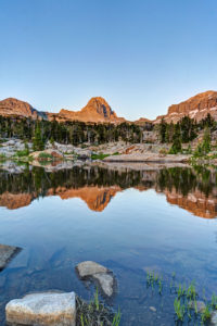
    It had been about 25 years since I had been up to Pitkin Lake in the Eagles Nest Wilderness near Vail so I decided to go back this past week. Pitkin Lake is a beautiful place. The hike features a couple of waterfalls, wildflower-filled meadows, and soaring peaks. What’s not to like? The steepness of the hike, for one. This is a challenging backpack. Although the trail is listed at 4.8 miles, the trek is far longer. It gains 3,000 vertical feet and takes about 4.5 hours and about 3.75 hours going down. My guess is this hike is closer to 5.7 miles each way, almost 2 miles longer roundtrip than advertised.

    The trail starts in East Vail by crossing Pitkin Creek almost immediately. Then the fun begins, It climbs steeply over the next .5 mile, gaining about 500 feet in elevation in the process. The trail mellows out a little but and then gets pretty flat as it wanders through aspen trees. At mile 1.9 (or 2.7 in actual distance), the trail provides an overlook of a large waterfall off to the right. From here, the trail ascends at a steep incline for the next 1.5 miles before it reaches a second waterfall, this time on the left. This stretch of trail left my quads burning and required a couple of breaks. It flattens out thankfully just before coming to a second waterfall at around mile 3.5 (4.3). Access is limited due to rocks and willows. I could not get a decent photo of it. Past the waterfall, the trail ascends steeply to the right of the waterfall and then alternates steep sections with flatter ones. The trail is quite marshy through this section and is quite mosquito-filled. Finally, the trial opens up into a beautiful meadow. The flowers were just beginning to pop in this section.

    Once you get to the lake, all is forgiven, however. It is a serene setting. Colorado cutthroat trout inhabit the lake and my son and I caught a couple. /we saw no none else camped in the basin which was amazing.

    Getting to the trialhead

    Parking is limited at this trail. There are about 20 spots but they are limited to three hours (not enouh time to do even half the trail). The best course is to park near the vail transit center and catch the free East Vail hiker express. The shuttle makes a few stops at the most popular trailheads. The one for this hike is Falls at Vail. The shuttle stop is about a .25 mile downhill from the trailhead. If you are backpacking and need overnight parking, the Redstone parking garage in West Vail is your best bet. It costs $15 for the night (as opposed to $30 in the lot by the transit center). You will need to walk an additional mile to get to this garage or catch the free shuttle from the transit center.

  • Alaska Basin

    Alaska Basin

    My wife and I just did a backpacking trip to Alaska Basin on the west side of the Tetons. The trip is not in Grand Teton National Park, but that makes it better in my opinion. There are no permits needed for the region and the scenery is just as iconic. The trail features several cascades, great wildflowers, and terrific mountain views. Alaska Basin contains several small ponds and lakes that make for some great photography.

    The trail starts at the South Teton Canyon Trailhead east of Driggs, Idaho. The first 2 miles meanders by the creek and is fairly flat. Then the fun starts. The trail climbs steadily through four or five meadows that filled with wildflowers. The views of the surrounding mountains are good as well here. At mile 2.7, the trail intersects with the trail to the Devil’s Stairs on the right. This side trail makes a loop with the main trail up at the basin if you so desire. We met several people doing the entire 16 miles in a day. The main trail continues steeply upward from this point. It climbs above the creek and enters a pine forest. Around mile 4.5, the trail ascends steep switchbacks and arroiuves at a meadow filled with columbine and cow parsnip. The trail levels off at this point and crosses the creek at mile 5.4. This crossing is a little tricky, especially on the way back. Watch for loose logs and rocks. There are two very nice cascades in this area as well.

    Starting at the 6 mile mark, the trail again ascends some rock stairs and arrives at a small meadow. Some nice views can be had here and there are nice fields of wildflowers in abundance. You can also see a large waterfall in the distance here. The trail then renters the forest and climbs up to the junctions with the Hurricane Pass trail at mile 7.7. This is where Alaska Basin lies. We day hiked this side trail but did not quite make it to the pass. This trail steeply climbs a rock bench to Sunset Lake with stunning views from above the lake. The route up to the pass is filled with wildflowers past the lake. Hurricane Pass provides panoramic views but I wimped out.

    Back in Alaska Basin, we camped near one of the small lakes. Mirror Lake is the biggest of the six or so lakes in the area and is the most photogenic in my opinion. It also gets the most campers. The trail divides .1 mile past the junction with the Hurricane Pass Trail. Rather confusingly, the trail for Mirror Lake is signed as the left branch, but Mirror Lake is actually more easily accessed by the right branch trail to Mt Meek Pass. No matter. Each of the lakes has a little different view and is worth exploring.

    One of the amazing features of this valley is that the sun has very little blocking it as it sets to the west. Thus, the mountains behind the lakes light up and turn amber and red in the evening light. It is quite a sight to behold. The back side of South Teton dominates the scene.

    Getting There

    Take Highway 22 west of Jackson, WY to Victor, Idaho. The road becomes Highway 33 in Idaho. Follow the road north to Driggs. Turn right on Ski Hill road and follow it about 5 miles. Turn right onto Teton Canyon Road. Follow the dirt road for about 4.6 miles until it dead ends at the South Teton Canon trailhead.

Plugin from the creators ofBrindes Personalizados :: More at PlulzWordpress Plugins