I hiked a loop from Bear Lake parking lot in Rocky Mountain National Park yesterday. I photographed the sunrise at Dream Lake and then ventured over the hill to Lake Hiyaha about 1 mile away. Although virtually at the same elevation, the two lakes are separated by a large hill that must be scaled. So the trail ascends and descends steeply form Dream Lake. Lake Hiyaha has a weird green mile color right now due to glacial sediment being disturbed. The lake itself is not very photogenic due to the presence of large boulders all along its shoreline. The tarn just in front of the lake was more photogenic in my mind. I then hiked the connector trail with the glacial gorge trail. About half a mile from the junction, there are two small tarns that are quite photogenic. I did get wet getting to the shore of one, however. It is quite the bog!
Tag: reflections
-

Alaska Basin
My wife and I just did a backpacking trip to Alaska Basin on the west side of the Tetons. The trip is not in Grand Teton National Park, but that makes it better in my opinion. There are no permits needed for the region and the scenery is just as iconic. The trail features several cascades, great wildflowers, and terrific mountain views. Alaska Basin contains several small ponds and lakes that make for some great photography.
The trail starts at the South Teton Canyon Trailhead east of Driggs, Idaho. The first 2 miles meanders by the creek and is fairly flat. Then the fun starts. The trail climbs steadily through four or five meadows that filled with wildflowers. The views of the surrounding mountains are good as well here. At mile 2.7, the trail intersects with the trail to the Devil’s Stairs on the right. This side trail makes a loop with the main trail up at the basin if you so desire. We met several people doing the entire 16 miles in a day. The main trail continues steeply upward from this point. It climbs above the creek and enters a pine forest. Around mile 4.5, the trail ascends steep switchbacks and arroiuves at a meadow filled with columbine and cow parsnip. The trail levels off at this point and crosses the creek at mile 5.4. This crossing is a little tricky, especially on the way back. Watch for loose logs and rocks. There are two very nice cascades in this area as well.
Starting at the 6 mile mark, the trail again ascends some rock stairs and arrives at a small meadow. Some nice views can be had here and there are nice fields of wildflowers in abundance. You can also see a large waterfall in the distance here. The trail then renters the forest and climbs up to the junctions with the Hurricane Pass trail at mile 7.7. This is where Alaska Basin lies. We day hiked this side trail but did not quite make it to the pass. This trail steeply climbs a rock bench to Sunset Lake with stunning views from above the lake. The route up to the pass is filled with wildflowers past the lake. Hurricane Pass provides panoramic views but I wimped out.
Back in Alaska Basin, we camped near one of the small lakes. Mirror Lake is the biggest of the six or so lakes in the area and is the most photogenic in my opinion. It also gets the most campers. The trail divides .1 mile past the junction with the Hurricane Pass Trail. Rather confusingly, the trail for Mirror Lake is signed as the left branch, but Mirror Lake is actually more easily accessed by the right branch trail to Mt Meek Pass. No matter. Each of the lakes has a little different view and is worth exploring.
One of the amazing features of this valley is that the sun has very little blocking it as it sets to the west. Thus, the mountains behind the lakes light up and turn amber and red in the evening light. It is quite a sight to behold. The back side of South Teton dominates the scene.
Getting There
Take Highway 22 west of Jackson, WY to Victor, Idaho. The road becomes Highway 33 in Idaho. Follow the road north to Driggs. Turn right on Ski Hill road and follow it about 5 miles. Turn right onto Teton Canyon Road. Follow the dirt road for about 4.6 miles until it dead ends at the South Teton Canon trailhead.
-
Gap Lakes
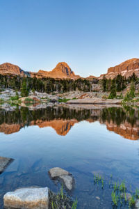
I backpacked to the Gap Lakes in the Snowy Range of Wyoming just before the eclipse. This is a pretty area with several small lakes and tarns just a short distance form the trailhead. I camped near South Gap Lake and explored some tarns around the area. There are many small ponds with beautiful reflections to photograph in this area. Lewis Lake at the trailhead is perhaps the prettiest of all the lakes. I will have to return to this area to do some fishing.
Getting There
The trailhead to the Gap Lakes is located at the Libby Lake and Lewis Lake picnic ground which is about a half a mile from the summit of the Snowy Range road. Proceed west out of Laramie, Wyoming for about 30 miles on the Snowy Range Road to reach this area. The trail itself climbs about two hundred feet in elevation from Lewis Lake and arrives at the Gap Lakes in less than a mile. You can explore the trial further to reach Deep Lake and other lakes in the region or take a different trail to reach Mirror Lake to the West.
-
Missouri Lakes
I backpacked into Missouri Lakes basin in the Holy Cross Wilderness in Colorado. I intended to complete the loop with Fancy Pass but too much snow at the top of the pass. I got hailed on twice but it was worth the effort. I saw an amazing sunset and the alpenglow on the mountains was stunning this morning. The basin has three large lakes and a number of small tarns that make for great reflection photography. I even caught a couple of brook trout out of the middle Missouri Lake. En route to the lakes, a number of cascades and waterfalls make the hard hike an enjoyable one.
Trail Description
The trail starts at the Missouri Lakes trailhead after an 11 mile drive on Forest Service roads. It begins gently as the trail parallels the creek. After a half a mile it begins to ascend more steeply. At around one mile, you are treated to a beautiful double waterfall. Unofruntately, there is no way to get close to the falls as the area is surrounded by dense undergrowth. Just ahead, a little pond is a good place to stop and grab a snack. From here, the trail begins ascending steeply and the trail becomes rocky. Cascade after cascade can be seen along the creek. At one point, the trail crosses the creek. Here, a the creek cascades through a granite gorge. The trail levels out monetarily as it crosses a boggy meadow. The trees start to thin as you approach Missouri Lakes basin. The first lake soon comes into view around mile 3. A number of small tarns can be found off trail just before the lake. A number of good camping sites can be found in this area. After passing the first lake, the trail makes a hard right turn up the hillside and the second lake can be found about 200 feet higher. The trail passes the second lake and the third lake comes into view on the left. For those wanting to take in the view, the trail climbs very steeply up to the pass. Snow will remain here into August this year it looks like.