Author: Derek Regensburger

  • Best of 2020 Wedding Photography

    Best of 2020 Wedding Photography

    I thought it might be a fun way to finish off 2020 by posting a best of my wedding and engagement photography for the year. Admittedly 2020 was a tough year with the spread of COVID-19 and cancellation of scores of weddings and events, but I put the extra time to good use and learned several new techniques. I am particularly intrigued by the high key lighting used for the bouquet and bridal flowers. I hope 2021 is a great year for weddings and events.

    Remember although I am located in Broomfield, I will travel across the state of Colorado for your wedding! If you questions about my packages and availability, please call Derek Regensburger at 303 478 7586 to inquire more about my services.

  • Canada Geese, Stearns Lake 2020

    Canada Geese, Stearns Lake 2020

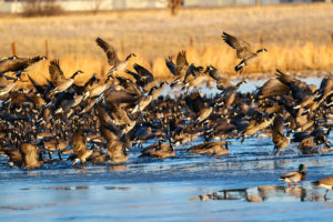
    One afternoon I found a couple thousand Canada geese on Stearns Lake in Lafayette, CO, so I decided to go back and photograph them the next morning. A brilliant sunrise and greeted me with purple and red colors when I arrived around 6:50 am. I photographed a few ducks flying through the clouds and then focused on the geese. After focusing on a large clump for about 10 minutes, the flock took off in unison into the lake. I wondered what had caused that reaction? My answer soon came flying over the lake–a bad eagle. I promptly snapped a dozen or so frames of the eagle which was an added bonus to an already gorgeous morning.

    I stayed for another half hour ro so taking in the scene and then watch wave after wave of geese take off. The Front Range mountains provided a beautiful backdrop. Thank goodness for the local farms and large estates preventing houses from coming right up to the lake so it certainly feels wild and remote, even though it is only 15 minutes from either Broomfield or Boulder. I will definitely go back to check out this very cool place.

  • Colorado Utah Football 2020

    I photographed the NCAA football game between Colorado and Utah today. I had to shoot from the stands due to COVID-19 restrictions and that was certainly a new experience. It gave a whole new perspective and it made following the action somewhat easier since I go all along the yard lines. I missed out on the shots from behind the end zone but I was still able to capture some cool shots. I have to admit it was odd having no fans, students, cheerleaders, or marching bands.

    Unfortunately, CU lost the game 38-21 after jumping out to a 21-10 lead at the start of the second half. Utah is the Buffaloes’ kryptonite I guess now having lost 4 straight to the Utes.

  • 2020 Colorado 4A Softball Final

    2020 Colorado 4A Softball Final

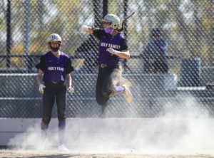
    It was a beautiful fall day for the Colorado 4A softball finals at Aurora Sports Park. Holy Family took home the crown, defeating Mead 9-6 in the final. The road to the title was a tough one for Holy Family as it had to overcome a 6-1 deficit in the semifinal matchup with D’Evelyn. Holy Family used the long ball to power its offense on the day. A first inning grand slam set the tone against Mead, putting the Tigers ahead 4-0.

  • Senior Portraits Ouray, CO

    Senior Portraits Ouray, CO

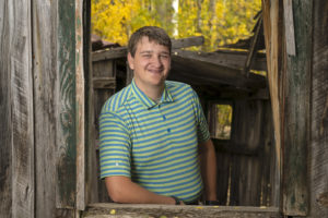
    I had a unique opportunity to shoot some senior portraits near Ouray, CO this past weekend. The fall colors were just about peak so the backdrop was gorgeous. I shot some in the old mining town of Ironton which made for some fun backdrops using the abandoned buildings in the area. I also used some aspen groves as a backdrop as well. The weather was just about perfect as the light overcast sky helped reduce contrast.

    My subject is an Eagle Scout and wanted an outdoor backdrop to show off his love of the outdoors.

    I lit the portraits using a Bowens XMT 500 strobe with a beauty dish. The combination worked great for a one light set up.

  • Eccles Pass

    Eccles Pass

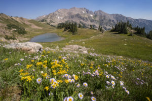
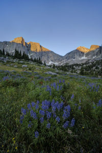
    Eccles Pass offers some panoramic views of the Eagles Nest Wilderness near Frisco, CO. I hiked up yesterday to catch the last of the wildflower show for 2020. Despite the haze from 4 wildfires burning in Colorado, it was a beautiful day and the wildflowers did not disappoint.

    To reach the summit of Eccles Pass requires just over a 5 mile hike. The Meadow Creek trail just outside of Frisco provides the primary access to the pass. The trail climbs through stands of aspen for the first mile as it works it way into the wilderness. The trail junction for the short trail to Lily Pad lake appears just after the .5 mile mark. Continue straight and follow the main trail as it quickly ascends through lodgepole pine. Around the 2 mile mark, the trail crosses Meadow Creek over a small bridge and then begins an arduous ascent along a rocky trail for the next 1.25 mile. The trail levels off at this point, and the forest transitions to spruce and fir. Around the 3.5 mile mark, the trail crosses the creek over some logs and limited views through the forest appear. At just over 4 miles, you reach a small beaver pond with dead pines along its shore. A good reflection of the mountains that ring the basin can be seen here. Continue on for about .5 mile and the views begin to open up around you. Shortly, you will come to a trail junction with the Gore Range trail. The faint trail to the left proceeds down to 10 Mile Creek. Go right to ascend the pass.

    This area used to contain a couple of large reflecting pools, but they are now unfortunately filled with grass. The last time I was up here, I photographed some beautiful reflections in the pools. Too bad they’re now history. The surrounding meadows are filled with wildflowers so there’s still beauty to take in, thankfully.

    After the steep climb to the summit of Eccles Pass, the trail drops into the valley below. There are a few small tarns and ponds as well as plenty of wildflowers to attract your eye. At this point, hikers have two options. Return the way you came or camp out in this lovely basin. Shuttle hikers can keep going over Red Buffalo Pass and will come out in East Vail. A side trip to the lovely Gore Lake is highly recommended for those doing this route.

  • Gore Lake

    Gore Lake

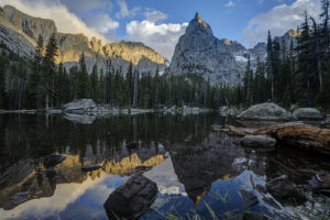
    Gore Lake is one of the prettiest in the Gore Range near Vail, CO. It also boasts some of the biggest trout you’ll see in an alpine environment. Which of course makes it a destination for any serious hiker, fisherman, or photographer. I happen to be all three so of course I had to visit the lake.

    The hike is 6.5 miles long and is steep in several sections. While arduous in spots, the nice thing about this trail it that it intersperses flat, level sections to allow you to catch your brief periodically. It begins at the Gore Creek trailhead off of the Big Horn Road near East Vail. The trail passes the junction with the Deluge Lake trail in about .25 mile and then climbs steeply up into the aspen forest. The aspen are dense for the first 1.5 miles and then give way to conifer forest. Around the 1.5 mile mark, the trail climbs a steep rocky section before crossing Deluge Creek over a bridge at the 2.5 mile mark. The trail passes through willow and several creeks cross the trail over the next mile. The trail now climbs steadily for the next half mile before flattening out on the approach to the trail junction at mile 5. Bear left to head to Gore Lake or stay straight if ascending the very steep Red Buffalo Pass.

    Bearing left to the lake you will pass a grave marker for two Swedes who died in the early 1900s. The next .75 mile is a lung and quad burner. It seems to head straight up the mountain in stretches. When you reach a small waterfall on your right, there is one last sharp incline before the trail flattens out in a lower meadow below the lake. You wander about .5 mile through a boggy environment as partial views of the mountains begin to open around you. Finally, the trail has one last steep section in store as it climbs the last 300 feet or so to Gore Lake over the last .5 mile. The climb is worth it as views of the peaks around the lake open all around. Look for the 18″-22″ cutthroat trout cruising the shallows of the lake. Then enjoy the fields of wildflowers to the south of the lake. This area boasts many good camping spots as well. Be sure to look for mountain goats in the area. I saw at a dozen watering about while I was there.

  • Crater Lake-Indian Peaks Wilderness

    Crater Lake-Indian Peaks Wilderness

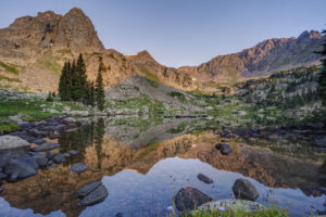
    The views from Crater Lake and Mirror Lake in the Indian Peaks Wilderness are some of the most iconic views in the Colorado mountains. I was excited to finally get a chance to see them on a recent backpacking trip with my sons. The area didn’t disappoint. Several fine waterfalls can be viewed along the Cascade Creek trail en route to the lakes. Both lakes are beautiful in their own right but the view from Mirror Lake with Lone Eagle Peak soaring behind it makes for a stunning photograph.

    The trail begins at the Monarch Lake trailhead at the back end of Granby Reservoir. It follows the north shoreline of Monarch Lake before entering the wilderness around mile 1.2. The trail reaches its first branch at mile 1.6 as the Arapaho Pass trail connects off to the right. Stay on the main trail and pass over Buchanan creek a bridge just over the 2 mile mark. The trail then begins to climb up switchbacks for a half mile or so before flattening out on its way to the junction with the Buchanan Pass trail. Bear right onto the Cascade Creek trail and cross over a bridge near the confluence of the two creeks. The trail climbs steeply to the first of many cascades. This one is notable for the narrow, rocky canyon it pours out from.

    The trail climbs again and you come to another bridge at 4.4 miles. Shortly thereafter, you come to the first of four cascades which comprise Cascade Falls. The trail becomes steep and rocky at this point as it winds its way past each of the four falls. The last one is located in an open valley at mile 5.2. The trail now opens into a large meadow filled with wildflowers in July. Several columbine paintbrush, and larkspur dot the hillside. This is a great spot for a rest as the trail begins a steep climb toward the junction with the Pawnee Pass trail. You reach the junction at mile 6.4. Pawnee Pass is to the left. Bear right and head toward the lake basin. The trail becomes very rocky here and quickly enters what looks like an abandoned stream bed. Climb up the narrow canyon and you come out atop a large rock slab. The area is marked with cairns.

    After a short jaunt through open forest, the trail again crosses Cascade Creek over a relatively new bridge at mile 7.4. You’re almost to Mirror Lake but you need to scale some switchbacks first. Finally, the epic view from the shore of Mirror Lake awaits around mile 7.8. Lone Eagle Peak’s pointed spire towers straight in front of you. If you’re spending the night, find an open campsite if you have the necessary reservation. There are 12 campsites in all between Mirror Lake and Crater Lake. Follow the trail to the left around the west side of the lake. It becomes very hard to follow in spots but just keep heading in this direction. Once you pass the far shore of the lake, you will come to a reflecting tarn with an amazing view of Lone Eagle Peak. Follow the trail around to the right and up over a large rock outcropping. Finally, you’ve reached the end of the trail at Crater Lake.

    I found sunset to be the the best time to shoot Mirror Lake but an hour after sunrise is also good. Crater Lake is best at sunrise.

  • Clear Lake-Wind Rivers

    Clear Lake-Wind Rivers

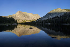
    Clear Lake in the Big Sandy Lake area of the Wind River range is one of the prettiest alpine lakes I’ve visited. It is set in a large bowl with large prominent mountain peaks surrounding it. Its large size adds to the drama of the setting. Wildflowers dot the meadows surrounding the north side of the lake as well.

    To reach the lake, hike the Big Sandy trail to Big Sandy Lake at the southern end of the wilderness. Then skirt the left side of the lake, pass the junction with the Big Sandy trail to Jackass Pass, and continue around the lake until you reach a crossing of the Big Sandy river. Several logs have been placed across the stream to aid in the crossing. Just before the crossing, you will see the only sign for Clear Lake–it points to Black Joe Lake and Clear Lake to the right. However, once the trail splits after the crossing, no signs tells you which way to go. I made the mistake of going left toward Black Joe lake. You can still reach Clear Lake from here but you needlessly ascend 300 more feet than necessary. So save yourself the trouble and go right at the junction. The trail finishes its circle of Big Sandy Lake and then ascends some gentle switchbacks up to Clear Lake. The lake is about 1 mile past Big Sandy Lake.

    The lake itself is ringed by trees but feels very open. The trail leads around the north side of the lake and continues up to Deep Lake about 1.5 miles up the trail. Clear Lake is a great spot to watch sunrise and sunset, particularly if the winds are calm. The lake can produce some stunning reflections.

  • Cirque of the Towers

    Cirque of the Towers

    My family and I recently backpacked to the Cirque of the Towers in the Wind River range of Wyoming. It is an amazing place where a lake is encircled by high peaks in a glacial basin. The Cirque had been on my radar as a place to visit for many years now so I’m glad I finally had a chance to get there. It was a rough hike but the effort was worth it. As an added bonus, I got to see the comet Neowise peaking out just above the horizon line one evening.

    The hike to the Cirque begins at the Big Sandy trailhead near the southern end of the range. The first section of the hike is a relatively easy jaunt to Big Sandy Lake, five miles from the trailhead. The trail begins by going through the forest before reaching a meadow around the .5 mile mark. From there, the trail begins to ascend up some switchbacks and then levels out around the two mile mark at another large meadow. Here, you begin to see views of the surrounding mountains. The trail again climbs gradually through the trees until arriving at the shores of Big Sandy Lake around mile 5. This is a good place to camp for the night or you can continue up the trail 1.5 to the incomparable Clear Lake.

    The trail skirts the left side of the lake, crosses a small stream, and reaches the junction with the Big Sandy trail to Jackass Pass at mile 5.5. The fun now begins. You gain 1700 feet in elevation in 3 miles but also lose 600 feet of elevation. For the junction, the trail immediately ascends via steep switchbacks to a beautiful meadow. It levels off for the half mile, reaching a small stream and pool. The trail crosses the creek and ascends via steep switchbacks. You climb 300 feet but then descend all 300 feet to the inlet of North Lake. Take a rest here because the trail now ascends up a steep slope through the rocks above Arrowhead Lake. It soon comes to a trail junction with the Arrowhead Lake climbing route. Go right and head up through the boulders above Arrowhead Lake. Here you begin to glimpse the amazing scenery of the area. Peaks soar around you. When you reach the high point, your heart sinks as you can now see the trail drops most of the way down to Arrowhead Lake before reascending to Jackass Pass. The trail splits in three after the descent, as the left branch descends the rest of the way to Arrowhead Lake, the central branch leads to the base of Cirque, and the right branch ascends the pass. Take the right fork and do one more steep climb before you finally reach the summit of the pass.

    At the pass, take in the view. The peaks of the Cirque of the Towers surround you and Lonesome Lake can be seen far below you. Peaks such as the Wolf’s Head, Shark Nose, and Pingora Peak cut a distinct profile. Follow the trail down toward the lake. You can proceed left to a large waterfall and the head of the basin or you can go right and camp past the lake and continue on the trail toward Papoose Lake. I camped in the area above the basin so I could visit the lake and waterfall. The lake contains many small cutthroat trout which are willing biters.

Plugin from the creators ofBrindes Personalizados :: More at PlulzWordpress Plugins