Tag: waterfalls

  • Alaska Basin

    Alaska Basin

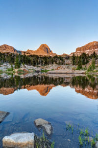
    My wife and I just did a backpacking trip to Alaska Basin on the west side of the Tetons. The trip is not in Grand Teton National Park, but that makes it better in my opinion. There are no permits needed for the region and the scenery is just as iconic. The trail features several cascades, great wildflowers, and terrific mountain views. Alaska Basin contains several small ponds and lakes that make for some great photography.

    The trail starts at the South Teton Canyon Trailhead east of Driggs, Idaho. The first 2 miles meanders by the creek and is fairly flat. Then the fun starts. The trail climbs steadily through four or five meadows that filled with wildflowers. The views of the surrounding mountains are good as well here. At mile 2.7, the trail intersects with the trail to the Devil’s Stairs on the right. This side trail makes a loop with the main trail up at the basin if you so desire. We met several people doing the entire 16 miles in a day. The main trail continues steeply upward from this point. It climbs above the creek and enters a pine forest. Around mile 4.5, the trail ascends steep switchbacks and arroiuves at a meadow filled with columbine and cow parsnip. The trail levels off at this point and crosses the creek at mile 5.4. This crossing is a little tricky, especially on the way back. Watch for loose logs and rocks. There are two very nice cascades in this area as well.

    Starting at the 6 mile mark, the trail again ascends some rock stairs and arrives at a small meadow. Some nice views can be had here and there are nice fields of wildflowers in abundance. You can also see a large waterfall in the distance here. The trail then renters the forest and climbs up to the junctions with the Hurricane Pass trail at mile 7.7. This is where Alaska Basin lies. We day hiked this side trail but did not quite make it to the pass. This trail steeply climbs a rock bench to Sunset Lake with stunning views from above the lake. The route up to the pass is filled with wildflowers past the lake. Hurricane Pass provides panoramic views but I wimped out.

    Back in Alaska Basin, we camped near one of the small lakes. Mirror Lake is the biggest of the six or so lakes in the area and is the most photogenic in my opinion. It also gets the most campers. The trail divides .1 mile past the junction with the Hurricane Pass Trail. Rather confusingly, the trail for Mirror Lake is signed as the left branch, but Mirror Lake is actually more easily accessed by the right branch trail to Mt Meek Pass. No matter. Each of the lakes has a little different view and is worth exploring.

    One of the amazing features of this valley is that the sun has very little blocking it as it sets to the west. Thus, the mountains behind the lakes light up and turn amber and red in the evening light. It is quite a sight to behold. The back side of South Teton dominates the scene.

    Getting There

    Take Highway 22 west of Jackson, WY to Victor, Idaho. The road becomes Highway 33 in Idaho. Follow the road north to Driggs. Turn right on Ski Hill road and follow it about 5 miles. Turn right onto Teton Canyon Road. Follow the dirt road for about 4.6 miles until it dead ends at the South Teton Canon trailhead.

  • East Inlet Trail Rocky Mountain National Park

    East Inlet Trail Rocky Mountain National Park

    I finally got a reservation to backpack the East Inlet Trail of Rocky Mountain National Park. Highlights include Adams Falls and a chain of five lakes. I made it to four of the lakes. My favorite was Spirit Lake. I also caught multiple brook trout in Lake Verna and Spirit Lake.

    Trail Description

    The trail starts out very easy. Adams Falls is accessed after about 1/3 mile on a short spur trail. It is a large cascade type waterfall. The trail continues east as it skirts the north side of a large meadow for about 2 miles. The trail here is nice and level but don’t be deceived. A steep trek awaits. About the 2.5 mile mark, you will pass the Lower East Inlet backcountry campsite. From here the trail begins to ascend steeply. Over the next mile you will learn to dread rock stairs because there are a ton of them. At the 3 mile mark, you will reach a large rock outcropping with a commanding view of Grand Lake to the west.

    The trail descends about 200 feet to join up with East Inlet Creek. The trail then mellows out for the next .5 mile or so until reaching Cat’s Lair campsite. Once again the trail climbs steeply through the forest and some fine cascades can be seen along the trail. At the 5.5 mile mark, you will reach Lone Pine Lake–the first in a chain of the five lakes. If you are not a strong backpacker, it is recommended to try and reserve one of the sites near this lake for the first night on the trail.

    After passing the lake, the trail once again ascends steeply through the granite slick rock face above the lake. There is a pretty waterfall shortly after passing the lake. The trail then ascends the steep cliff face on a long bench. This half mile is very steep. At the top of this stretch, you are rewarded with a commanding view of Lone Pine Lake, now about 500 feet below. The trail now follows the creek along a relatively flat street as it makes it way to Lake Verna. You will pass a small lake first that has been formed from a large rock fall damming the creek. At the 7 mile mark, you will reach Lake Verna. Here the maintained trail ends and you will have to follow the social trail to the next three lakes.

    Getting up the trail is challenging as many pines have been blown over and require constant scrambling and route finding. It is best to stay along the shore of lakes and by East Inlet Creek. Spirit Lake is next up and is located about .5 mile form the east shoreline of Lake Verna. Be sure to take in the afternoon sun on the nice beach on the east short of Verna first. The views begin to open up even more as you reach Spirit Lake. This is indeed a crown jewel of this chain. I hiked up to Fourth Lake but frankly it wasn’t;t worth the effort. It is a small marshy lake that is not as interesting. If you intend to reach Fifth Lake, you have to hike through more downed timber for the next 1/2 mile before reaching the open valley where Fifth Lake is located. It looked amazing up there but I was too tired by this point to head up.

    Trailhead Parking

    To access the East Inlet Trail, follow the main road into

  • Booth Falls

    Booth Falls

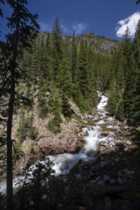
    Booth Falls is a strenuous hike to a 60 foot waterfall in the Gore Range in the Eagles Nest Wilderness near Vail, CO. The falls plunge down a steep crack at the top of a rocky canyon. Views of the cascades above the falls are easy but a steep drop over a small cliff restricts the views of the actual falls themselves.

    The hike to Booth Falls begins steeply as the trail switchbacks above the parking lot. After a half mile the trail eases a little as it follows Booth Creek. Around the 1.25 mile mark, the trail then climbs very steeply up to a rocky bench as ascends through an avalanche zone filled with raspberry and huckleberry bushes. The falls is located off the left side of the trail just past the 2.0 mark. Expect it take 1.5 hours to reach the falls. The trail continues above the falls, reaching Booth Lake in about 5 miles from the trailhead.

    To get to the trailhead, take I-70 to Exit 180 in East Vail. Turn right at the exit and then make a left on the frontage road. Drive for a mile and then turn right at the sign for the falls. If the main lot is full, overflow parking can be usually found at the Vail Mountain School just down the rod.

  • Snake River Waterfalls

    While on a trip to Idaho, I stopped to photograph some of the prettiest waterfalls along the Snake River.  The first was Fall Creek Falls near Idaho Falls. The falls is formed by Fall Creek flowing into the Snake River.  It creates a terraced waterfall with green moss and grass around the edges. Then, after a trek through the Sawtooth Wilderness, I stopped in Twin Falls to photograph two of the more dramatic waterfalls in the state–the famous Shoshone Falls and its smaller cousin, Perrine Coulee Falls. Shoshone Falls is a massive fall over a dam in the Snake River Canyon. It tumbles over a 200 foot drop in the river creating a powerful waterfall that rivals Niagara Falls. An overlook at the edge of a small park allows visitors to take in the falls and get an up-close view of its power. The spray form the falls is an awesome sight to behold. Further down the Snake River just past the Perrine bridge, Perrine Coulee Falls pours into the Snake River.  Although much smaller than Shoshone Falls, this is a wonderful waterfall to visit because you can walk behind it.  

    Getting There

    Shoshone Falls is located off of Falls avenue about 4 miles east of Highway 93. Cross the Snake River bridge on your way into town on Highway 93 and turn left onto Falls Avenue. Take Falls Avenue east for 4 miles and turn left following the signs for Shoshone Falls park. It is about a 1 mile to reach the park where the road dead ends. There are two overlooks to view the falls from at the park and and a path that leads along the river. There is a high railing that encircles the observation deck so you can either brace your camera on it or bring a tall tripod. The falls faces west so it best photographed before sunrise, in the late afternoon, or ideally at sunset. I arrived near sunset and all the shadows and contrast issues were eliminated due to the late hour.  There is normally a $3.00 fee to park when the entrance gate is manned.

    Perrin Coulee Falls is harder to locate.  Many locals don’t even know of its existence as I had trouble getting directions. The best way to get there is to take Highway 93 north toward the Snake River bridge.  Then turn left at Canyon Springs Rd, just past the mall.  Take the road halfway down.  You will then see a pullout on the right.  Park here and cross the road.  There is a small entrance down some rocks around a large bush.  You will see a path leading behind the waterfall.  You can also access the falls from the bottom.  There is a steep path that leads up to it. I found the best view was from the back or the left side in the morning. 

  • Coyote Gulch

    I backpacked into Coyote Gulch in the Grand Staircase-Escalante National Monument in southern Utah this past week.  I had been wanting to do this trip for the past ten years or so.  I failed once trying to squeeze my pack through the crack-in-the-wall route so this time I simply hiked in through Hurricane Wash.  I walked 25 miles in two days but it was worth the effort.  Coyote Gulch is an amazing place.  It features several waterfalls, a large arch, and towering canyon walls. It is also a very peaceful walk through a verdant canyon in the middle of a desert.  Below is the trail description.

    Hurricane Wash

    The guidebooks warn that this hike is rather dull to start and I think that is a little unfair.  While the first couple miles are rather unremarkable, parts of Hurricane Wash are actually pretty scenic.  The wash itself is 5.5 miles long to the confluence with Coyote Gulch.  The wash is sandy for the first four miles.  Luckily, an overland trail avoids the wash for the first couple of miles, meaning you’re walking in sand for only about 2 miles of the trip.  The canyon walls pop up after about two miles and this is where the hike starts to get interesting.  The trail passes the Glen Canyon boundary at mile 3.0.  Shortly thereafter, the canyon enters a short narrows section which is quite pretty.  At mile 4.0, the landscape changes.  Tamarisk and reeds dominate and a trickle of water becomes evident.  You pass by a large rock in thee stream bed that looks like it has been blasted from the hillside and then a fenced gate at around mile 5.0.  Finally, you come to the confluence.  This area features a much wider stream and and several canyon faces greet you downstream to the right. On the way back, I found out how the wash got its name.  The wind rips through it when a front is approaching.   

    Coyote Gulch

    The wading in the stream now begins in earnest.  The trail criss-crosses the stream multiple times throughout your journey through the gulch.  You’ll need wading shoes unless you want to get your boots wet.  I opted to hike in tennis shoes and neoprene socks.  You pass a couple of very large rock alcoves which have a nice orange color to them.  At around mile 7.0, you come to the first main feature of Coyote Gulch–Jacob Hamblin Arch.  The Arch towers above you to the left.  The arch is a good photo around two hours before sunset or at an hour after sunrise on the reverse side (but alas I went through it around 1pm).  There are multiple campsites on either side of the arch and one directly below it.  This is a good spot for a star shot, but I didn’t bring my Canon on the trip due to weight.  I continued downstream from here and soon came to the Swiss Cheese falls.  This is an area in the stream with some great fluted rock that the stream flows through.  I camped here under another large alcove.  Watch for falling rock here.  The rubble pile is impressive!  

    The next main feature in the canyon is Coyote Natural Bridge another mile or so downstream.  This is another large arch (bridge since it is over the stream).  This is more of a midday shot since the light doesn’t reach down into this part of the canyon except for that time.  At this point, my recommendation is to turn around and go back to camp unless you are up for a very long walk.  If I had to do it over agin, I would have stopped here and turned around and done the waterfall section as a day hike from Crack in the Wall.  Why? To be blunt, the next section of canyon is very dull and a long walk through reeds and tamarisk, and reeds and tamarisk, and reeds and tamarisk.  There is nothing to see for 2.0 miles.  Finally, you come to the first of the waterfalls past Cliff Arch.  To reach this place requires hiking around a boulder field to the left and then crossing the stream and scrambling above the boulder field to the right.  It is a pretty waterfall to be sure.  Some trees frame it and the canyon provides an amazing backdrop.  The trail then continues for about .75 miles to the next falls.  To reach this one, you need to descend the boulders to the right.  I then walked to another waterfall a short distance from this one.  I stopped here.  The route down below this falls looked difficult and I had hiked almost 12 miles to this point and had a 4.0 mile walk back to camp.  I will have to do the rest of the 2.0 miles of the gulch next time.  

    Driving Directions

    To reach Hurricane Wash, take the Hole in the Rock Road 5.0 miles east of Escalante or 18.0 miles south of Boulder.  Drive 33 miles down the worst washboarded road you’ve ever seen until coming to the parking area for Hurricane Wash.  Follow the trail down the wash and have fun! You don’t need 4×4 for the road, but a tougher vehicle may be nice for the bumps.  

  • Waterfalls of Northeastern Pennsylvania

    I just got back from a trip to Pennsylvania.  While I was there, I hiked to a number of waterfalls in northeastern Pennsylvania.  I visited Ricketts Glen State Park and several falls in the Delaware Water Gap.  While the falls are not huge, they are very ornate and pretty.  Many have incredible rock ledges or steps over which the water flows. I came away with a number of interesting compositions on the trip.  

    Ricketts Glen State Park

    The Ganoga Glen of Ricketts Glen State Park has ten waterfalls that appear one after another in a short 1 mile stretch of creek.  Then as you loop back up Glen Leigh, more waterfalls await.  I think I counted sixteen waterfalls in the span off a 4.5 mile round-trip hike.  This quickly became one of my favorite spots to see waterfalls in the U.S.  The trail descends steeply from a parking area and you reach Mohawk Falls after a short hike.  From there, waterfalls keep coming as you descend rock stair after rock stair. The tallest falls is just under 100 feet–Ganoga Falls.  But even a small ten-foot drop makes for a good photograph in this beautiful park.  I found Delaware Falls particularly photogenic with its tree-strewn cascades.  Mohican Falls is also very photogenic because of a large tree that has fallen along side of it.  The falls also reflects in the calm pool in front of it–a double bonus.  After Tuscarora Falls, the waters of the two creeks converge and you cross a bridge to head up Glen Leigh.  More waterfalls greet you as you climb back up to the parking lot.  The nice feature about Ricketts Glen is that the falls are often shaded by trees so you can get good photographs even on a sunny day as I had for the hike.  

    Delaware Water Gap

    The Delaware Water Gap National Recreation area contains several waterfalls along its many creeks that feed into the Delaware River. I visited three areas: Hornsbeck Creek, Dingman’s Falls, and Raymondskill Falls.  All are located just off Highway 209 in ascending order as you head north.  

    Hornsbeck Creek

    I think the most interesting waterfall to photograph was along Hornsbeck Creek.  The creek is located about 2 miles north of the Pocono Environmental Education Center off Emery Road.  The trail follows the north side of the creek as it descends below the road.  You come to the falls after about a half mile hike.  A short but steep faint trail leads down to the base of the waterfall.  It was a cool place to see but hard to photograph on a sunny day.  Lots of contrast!  

    Dingman’s Falls 

    The parking lot and trail to Dingman’s Falls is located just a little farther north on 209.  The trail first stops by the extremely thin but beautiful Silverthread Falls.  It is long and narrow and somewhat hard to photograph but still worth a stop.  The trail then winds around fro another half mile before reaching Dingman’s Falls.  This falls is much bigger.  A moderate wide angle or short telephoto would be ideal to photograph this waterfall as you can’t get right up to it.  

    Raymondskill Falls

    Raymondskill Falls is the last of the trio of waterfalls along 209.  It is allegedly the tallest falls in Pennsylvania but this is misleading.  It has several different drops and the main falls is not that large in and of itself.  It is still worth a stop and takes only a short hike along a loop trail to see the main falls.  


  • Missouri Lakes

    I backpacked into Missouri Lakes basin in the Holy Cross Wilderness in Colorado.  I intended to complete the loop with Fancy Pass but too much snow at the top of the pass.  I got hailed on twice but it was worth the effort.  I saw an amazing sunset and the alpenglow on the mountains was stunning this morning.  The basin has three large lakes and a number of small tarns that make for great reflection photography.  I even caught a couple of brook trout out of the middle Missouri Lake.  En route to the lakes, a number of cascades and waterfalls make the hard hike an enjoyable one.  

    Trail Description

    The trail starts at the Missouri Lakes trailhead after an 11 mile drive on Forest Service roads.  It begins gently as the trail parallels the creek.  After a half a mile it begins to ascend more steeply.  At around one mile, you are treated to a beautiful double waterfall.  Unofruntately, there is no way to get close to the falls as the area is surrounded by dense undergrowth.  Just ahead, a little pond is a good place to stop and grab a snack.  From here, the trail begins ascending steeply and the trail becomes rocky.  Cascade after cascade can be seen along the creek.  At one point, the trail crosses the creek.  Here, a the creek cascades through a granite gorge. The trail levels out monetarily as it crosses a boggy meadow.  The trees start to thin as you approach Missouri Lakes basin.  The first lake soon comes into view around mile 3.  A number of small tarns can be found off trail just before the lake.  A number of good camping sites can be found in this area.  After passing the first lake, the trail makes a hard right turn up the hillside and the second lake can be found about 200 feet higher.  The trail passes the second lake and the third lake comes into view on the left.  For those wanting to take in the view, the trail climbs very steeply up to the pass.  Snow will remain here into August this year it looks like.  


  • King Lake

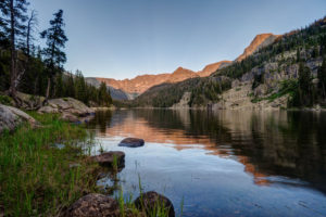
    The long hike to King Lake in the Indian Peaks Wilderness is worth the effort.  Near the end, you are rewarded with great views, rushing water, and abundant wildflowers.  Getting there requires a 6.5 mile hike from the Hessie Trailhead near Nederland, CO.  The trail begins steeply as it climbs over a rocky slope before reaching a trail divide after 1.5 miles.  Veer left (the right branch goes toward Jasper Lake). The trail crosses the creek and climbs past a beautiful waterfall.  You reach a trail divide again at mile marker 2.5.  Keep straight.  Then the trail enters the forest and climbs only gradually for the next three miles.  Not many views are found during this portion of the hike. Finally, the trail joins up with the creek again at around mile 5.5.  The next mile is steep as it switch backs up to a meeting with the Betty and Bob Lakes trail.  Just past the junction you have to cross the creek to reach King Lake.  In high water, the creek can be crossed easier to the right and then skirting back to the trail through some large boulders.  Finally, after a long hike, you reach the pretty shores of King Lake.  


  • Black Lake

    Black Lake in Rocky Mountain National Park is a long but rewarding hike in the Glacier Gorge area of the park.  The hike features a couple of beautiful lakes (including its namesake) and several waterfalls, including the elegant Ribbon Falls.  Ribbon Falls is a thin slip of a waterfall that descends a wide section of granite just below Black Lake.  Along the way, hikers are treated to several other cascades along Glacier Creek.  

    Trail Description

    The hike to Black Lake starts at the Glacier Gorge trailhead.  The trail climbs steadily to Alberta Falls, about a mile up the trail.  The falls thunders over the rocks.  Although it’s only a 25 foot drop, the falls is quite a sight.  This is the end of the road for many a hiker.  But the fun is just beginning.  Another small waterfall can be found just a few switchbacks up the trail.  The falls is tucked into a little hidden alcove.  Continuing up the trail, you reach a trail junction at mile 1.7 and bear right.  The left branch heads to the boulder field atop Long’s Peak.  Here, the trail cuts across a flat section of trail and approaches the canyon where lakes are located.  At mile 2.2, the trail divides again–the left branch heads toward Mills and Black Lakes, the right toward the Loch.  The trail climbs a series of steps and crosses the creek just before reaching Mills Lake.  Mills Lake is a calm respite and provides a good spot to grab a snack near the half-way point of the hike.  Try and spot a trout in its calm, shallow waters.

    The trail then goes along the left side of the lake and parallels the creek for the next mile.  This section of trail ascends gradually and makes its way through an area of tree blowdown.   At mile 4, the trail begins to ascend more steeply.  The thunderous sound of Ribbon Falls greets you at mile 4.5.  This is a hard waterfall to photograph given its unique structure.  Going wide here will help.  You can walk off trail and reach the bottom of Ribbon Falls.  The next sight is the outlet of Black Lake.  The mountains in the background frame the falls beautifully.  Amending the steps above the outlet, you finally reach Black Lake.  


  • Calf Creek Falls

    I decided to hike to Calf Creek Falls in the Escalante National Monument near Escalante, Utah this past weekend. Cloudy weather had put a damper on my plans to do some hiking along the Hole-in-the-Rock Road, so I stopped at the trailhead for the falls.  Calf Creek  Falls is a beautiful reward after a somewhat easy 3-mile hike through a pretty, riparian canyon.  The trail follows Calf Creek as it meanders through a deep canyon.  Along the way, many species of trees and birds can be spotted.  A number of Claret Cup cacti were blooming with their scarlet flowers as well.  The only drawback to the hike is that is features walking though deep sand the land mile or so.  The falls is tucked away at the end of the canyon.  

    The trailhead for Calf Creek Falls is located about 15 miles form Escalante or 13 miles south of Boulder Town along Highway 12.     

Plugin from the creators ofBrindes Personalizados :: More at PlulzWordpress Plugins