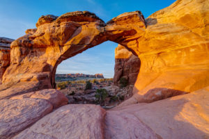
I traveled to southern Utah near Zion National Park. My two big stops were the Subway hike in Zion and White Pocket in the Paria/Vermillion Cliffs Wilderness.
The Subway
I had made one prior attempt to hike the Subway in Zion but never made it past the waterfall you have to hike over. This time I came prepared with water shoes. The hike starts off the Kolob Reservoir Road about 13 miles from the visitor center. I picked up my permit and headed to the trailhead. The first part of the hike meanders through junipers and then descends steeply (400 ft.) to the canyon floor around the 1.5 mile mark. The trail then skirts the creek for the next couple of miles, crossing it several times. There are a few areas where the trial climbs over boulders and trees. In April, the water wasn’t too high so this was not much of an issue. At mile 3, I reached a large, stepped waterfall with huge boulders in the creek. The only way to keep going is to walk through the water up the waterfall. The stair steps are relatively easy to climb so this was not much of an issue. But watershoes are helpful here since the water can be six inches deep in places. In about a half mile, I came to another stepped cascade. This one is a beautiful spot for some photography. This falls can be negotiated by walking around to the right of it. Just above this fall, is the famous crack where water flows through like a train track. It makes for some cool photos but the rock is incredibly slippery here so beware. The Subway is just a couple hundred yards around the bend from this area. The Subway itself has some amazing sculpted pools and the curved rock that forms the Subway. I was lucky enough to have a couple of large tree branches sticking out of the pools to create some cool looks. The trail continues up some small riffles (very slick) to where it reaches hip deep pools. Just beyond is a little waterfall that I did not see. Little too cold in April to trudge through the pools. The famous tree log is one level higher, but I would have needed a 15 ft rope to ascend the falls to get there.


Left Fork of North Creek, Zion National Park, UT

Left Fork of North Creek, Zion National Park, UT

Left Fork of North Creek, Zion National Park, UT

Left Fork of North Creek, Zion National Park, UT

Left Fork of North Creek, Zion National Park, UT

The Subway, Zion National Park, UT

The Subway, Zion National Park, UT

The Subway, Zion National Park, UT

The Subway, Zion National Park, UT
White Pocket
The next stop I made was at White Pocket. It is located just south of Big Water, UT but to reach the area requires about 1.5 hours of backroad travel on 4-wheel roads. I went with an outfitter to avoid getting stuck in the sand along the way. I camped out to try and take advantage of the golden hour and overnight but clouds ruined my plan. Sunset and overnight were a bust. I did get some nice light in the morning so here are a few photographs of the very bizarre White Pocket area. The area gets its name from the holes or “pockets” in the rock that trap rain water. There was a little water in some of them so I was able to capture a couple of reflections. I also hiked to some of the more remote formations that torus don’t stop at. One was reminiscent of South Coyote Buttes with lots of sandstone fins. Very cool.

White pocket, paria vermillion cliffs national monument, UT

Reflection, White pocket, paria vermillion cliffs national monument, UT

White pocket, paria vermillion cliffs national monument, UT

White pocket, paria vermillion cliffs national monument, UT

White pocket, paria vermillion cliffs national monument, UT

White pocket, paria vermillion cliffs national monument, UT

White pocket, paria vermillion cliffs national monument, UT

White pocket, paria vermillion cliffs national monument, UT

White pocket, paria vermillion cliffs national monument, UT

White pocket, paria vermillion cliffs national monument, UT

White pocket, paria vermillion cliffs national monument, UT

White pocket, paria vermillion cliffs national monument, UT

White pocket, paria vermillion cliffs national monument, UT

White pocket, paria vermillion cliffs national monument, UT

White pocket, paria vermillion cliffs national monument, UT

White pocket, paria vermillion cliffs national monument, UT

White pocket, paria vermillion cliffs national monument, UT

White pocket, paria vermillion cliffs national monument, UT

White pocket, paria vermillion cliffs national monument, UT